Cygnus, Thoth, XPI, and the Brodgar Complex

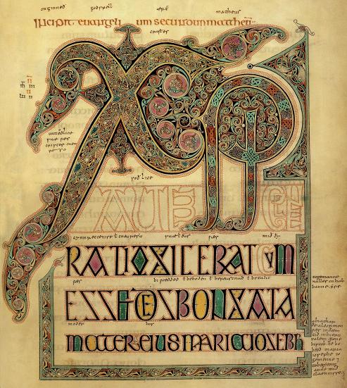
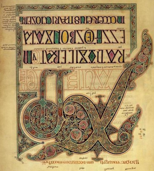
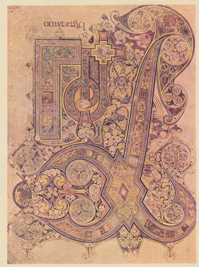
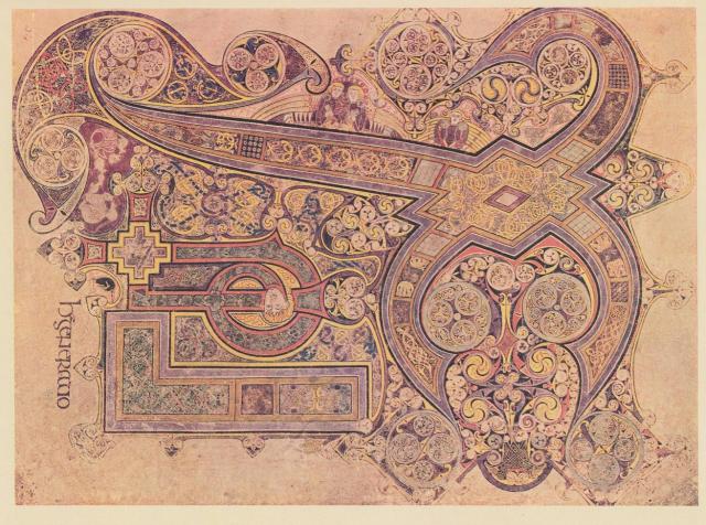
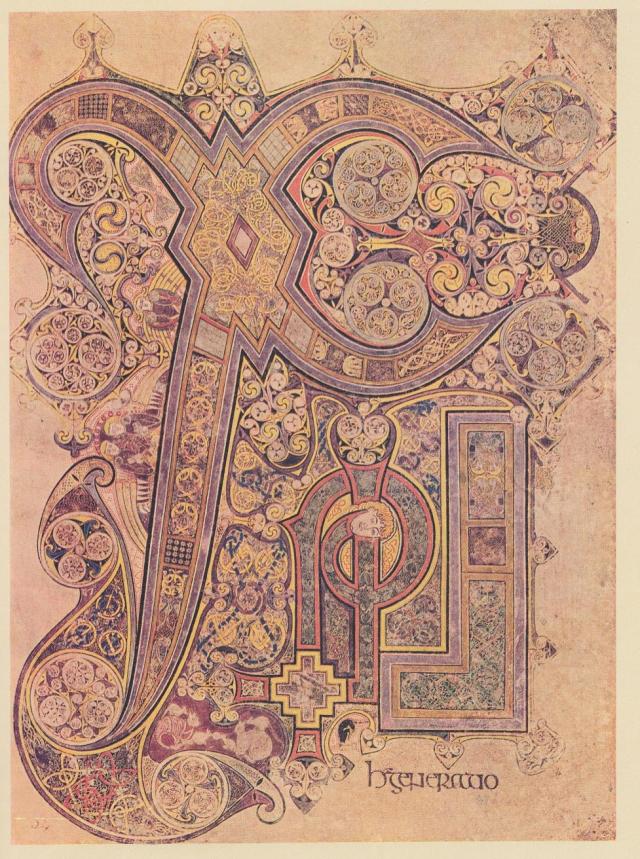
The story about the two XPI pages from the Book of Kells and the Lindisfarne Gospels, has become somewhat more complicated, but much more enlightening, since it explains why these two pages used the same theme. At these two places. The Book of Kells was made on the Island of Iona, which is on the west side of northern Scotland. The Lindisfarne Gospels were made at Holy Island, off the north east coast of England. Iona was the mother house to Lindisfarne.

The big X on both pages, which is a bird, the Swan, is laying an egg with his wing tip upon something with the head of an Ibis. There’s the head of a man, who seems to be wearing some sort of turban. They both have the straight staff and the one with the curl in it, which are the bird’s legs. They both have many other things made up of triskels, which make up little pictures, and both have birds entwined. The Book of Kells also has serpents  and ‘beard pullers’ entwined. These two pages belong to the story, ” Thoth, as the Ibis, laid an egg on the Mound of Creation, which is Hathor as the Milky Way. From the egg, Ra, the Sun god was born”. Even though both these pages say XPI for Christos, which is the Greek version of the name. The early Christian manuscripts were written in Greek, Latin didn’t come to the UK and Ireland for a few centuries after Christianity arrived.  Both books do use Latin in the script, but in special cases, Greek still shows up, particularly in the Book of Kells. As in the word Christos, since the monk who created the page in the Book of Kells, actually spelled out the word on the page. He also used Ogham to give symbolic messaging, craftily hidden in plain sight. That is, if you can recognize it.

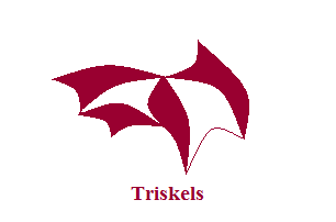
Triskels are basically shapes with three corners, which according to the experts represent the Trinity, but they came into existence long before Christianity, so a different sort of Trinity at one time. Past, Present and Future, the three Planes of Existence. The picture below  shows the sorts of shapes they could become, but the sky’s the limit when it comes to the different shapes, as long as they had three corners. Beard pullers are men with one lock of hair and their beards knotted up with each other or some other object.

Sometimes when I want to write about a topic, I seem to hold back. It’s not prevarication, rather it feels like waiting. Waiting for what? Waiting, because I feel that there is something missing about that particular topic. Something which will be important, something which might explain the subject. I take notice of this feeling, because I have found other things when this has happened before. I generally search the web for artefacts and articles, or I read some of my books, not really knowing what I’m looking for, but knowing I’ll find what ever it is I’m supposed to find. Quite often, the find is a coincidence, like someone posting an address on another blog, which just happens to give me one of my answers. This did in fact happen this time, but along with that, I also found something else. The two together are quite interesting.

The first thing I came across, were some papers written by Derek Cunningham, in which he theorizes that there was once a world map created, which was based on Cygnus. He actually started out trying to disprove the theories of Andrew Collins in the Cygnus Mystery. Andrew Collins and Rodney Hales showed how the layout for the Great pyramid and its companions match the formation of Cygnus better than Orion, which is logical, since Thoth was supposed to have been the architect of the Great pyramid. Thoth being Cygnus, usually shown as the Ibis. Instead, Derek Cunningham found that this theory is correct, and that it connects to a whole world map based on Cygnus, the Swan or Northern Cross, which seems to have been used by ancient mariners. Just can’t get away from those astronomer/navigators. His theories, maps, and pictures do suggest that he is correct about the world map.

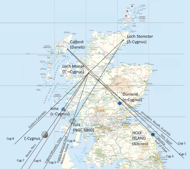
His map of Cygnus on the landscape of Scotland was based on geoglyphs that he found. They include large Xs, parallel lines, a triangle with lines leading in all directions coming off it, and some strangely shaped lakes. He also took into account the ancient Christian places of Iona, Dunkeld and Holy Island because they were supposed to have been built on land which was sacred long before Christianity came along.  Close to Dunkeld there is a nest of lines, parallel, triangular, etc. The map below is part of the result. This is a mirror image of what appeared in the sky when  this mapping system began, which Derek Cunningham dates to between 10,000-12,000 BCE. So right after the Big Ice had mostly melted away. As can be seen, these lines run to other important places in the world, and one from Calbost runs all the way to Giza in Egypt and beyond. It could take you to Australia, particularly if there was a canal in ancient times where the Suez canal is now. I have read about such a canal more than once in my lifetime. The line running to Jerusalem is likely Mount Carmel which figures in the St. Michael-Apollo Line.

However, Scotland didn’t look quite like this at the time, since this is before the Storrega Slide, and the incredibly bad tsunami it created, wiping out a great deal of Doggerland, and parts of Scotland. The Hebrides and the Orkneys were then part of a solid piece of land as shown below. These Islands must have been high points of land for them to have survived the flooding.  This is likely why so many islands, all the way back to Cyprus, were considered holy islands. They survived all the flooding which took place after the Ice Age ended. This is probably why so many ancient constructions were placed on high ground, they might survive if there was ever anymore flooding. This likely accounts for megalithic building, even though most of it happened much later.

The three red dots on Derek’s map, are ones I added. These are three wing stars which are part of Cygnus, which he didn’t take into account, but I did, knowing what is up there. Many Christian, Roman and Norman sites were built over much older sites, which were part of the original geodesy. It is possible that the very early Church had people who still understood this. At least it would seem so with the two XPI pages.

These three dots are very important to this story. I first put in the dots, and then went to look at a close up map of the locations. One is on Mainland Orkney, where there are two major roads which cross in a  big X formation. One dot falls on water, possibly land when this was created. The third dot is on Papa Westray, where an ancient tomb named the Holm of Papa Westray, and the Knap of Howar can be found. Up until a few years ago, the Knap of Howar was the oldest farm in Europe, it dates c3700 BCE. Since then, another farm has been discovered on the east side of Scotland, which has been dated c4000 BCE. The people there kept cattle, sheep and pigs, and grew several types of grain crops. The island of Wyre has also produced a settlement which so far dates c3300 BCE. Jura had people settled there in the Mesolithic. Scotland is becoming a regular hotbed of ancient constructions, and archaeologists are now realizing that the Orkneys do seem to have been the centre of some very important goings on. There’s the Barnhouse settlement close to the Stones of Stennes, and possibly two close to the Ring of Brodgar. One settlement has been found north of Brodgar by magnetometry scans, a whole new settlement which was unknown up until now.

It is the view of the archaeologists that the whole peninsula of Brodgar could well hold a great deal more. A circular enclosure has been spotted from the air close to Maeshowe, although it isn’t known at present what this might be. What has been uncovered so far at Brodgar, suggests that there were alignments to the Equinoxes and the Solstices, so all Solar.

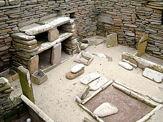
These buildings at Ness Brodgar are quite substantial, particularly Structure Ten. It measures 25 metres (82 feet) long and 20 metres (65 feet) wide in outside dimensions. The walls are five metres thick. It has a paved walkway all around, which may also have been covered by the roof.  Inside have been found a central hearth and four ‘dressers’, although these are now being viewed as ‘altars’. These were free-standing rather than placed against the wall as at Skara Brae. Far enough away from the wall so that you could walk around it.  They were made of yellow and red sandstone, their origin is not known at the moment, but this sandstone was brought from elsewhere.

                                                                            A  typical ‘dresser’ at Skara Brae

Structure Ten at Brodgar has now been jokingly called the ‘Cathedral’. Structure Eight at the Barnhouse settlement, close to the Stones of Stennes, shows evidence of having had a slate roof, many slates were found inside, all nicely even in thickness and cut squarely. Some have also been found in structure Ten. Neither hearth in Ten or Eight seems to have been used for cooking, all cooking at Eight seems to have taken place in an adjacent paved area outside. At Skara Brae, all the cooking seems to have been done in a building separate from the rest. Very monastic-like.

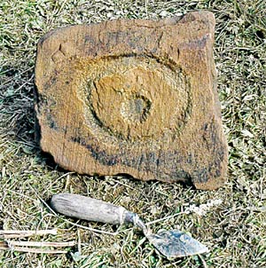
The outside stonework of Structure Ten was very well made and quite beautiful, but the inside stonework was rather “scrappy”, says Nick Card, archaeologist at the site, as if the building was meant to impress from the outside, but few people may have actually used the inside. The building is aligned east/west, with an entrance in the east, an Equinox alignment. Near the altar/dresser, which faces the east entrance, was found a stone now known as the Brodgar Eye. It is thought to have been part of this altar/dresser, and that the Equinox Sunrise would have shone right on it. Nick Card wondered if this was a Sun symbol. Yes indeed, it is a very ancient Sun symbol, and in Egypt it was a symbol for light. The monk who created the XPI page from Lindisfarne, used it on that page. The Druid’s beard is flowing toward it.

My own thought about this building, is that this was the headquarters and workplace of the astronomer/navigators. The altar/dressers were desks, a work surface to create maps on, likely made on hides. The tops themselves may have star maps on them, since they have pecking and cup marks and ‘decoration’ on them. The shelves below were for these rolled up hide maps, their ink cakes and pens made of reeds or quills. Swan’s quills? The Equinox Sunrise alignment makes perfect sense, the best long distance sailing time occurs between the Spring and Fall Equinox, particularly in a time with no motors, radio, radar, GPS, and all the other modern gear we have today. Even with all that, the Atlantic is no picnic in December.

It is starting to look as if all the Orkney Islands were inhabited in the Neolithic and Bronze Age, and that they were inhabited for at least a thousand years.  But the excavations are nowhere near finished, and the archaeologists think that there could still be whole layers of other constructions further down at Brodgar, which could show that it was inhabited for a much longer time. At the Links of Notland, on Westray, another settlement is being excavated. This is where the Orkney Venus was found. It has the same eyebrow/eye motif which was found at the Holm of Papa Westray, a chambered cairn.

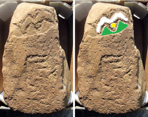
These carvings are reminiscent of the Folkton Drums which also have the eyebrow/eye motif on them.  The motif on the Folkton Drums is part of the Akhet, the Sun between two mountains. The Winter Solstice Sunset, as seen from Maeshowe and other places belonging to the Brodgar Complex, happens between two mountains, where it sets into the Island of Hoy. There are special sightings of Venus about those same mountains. The eyebrows on the Folkton Drums is a large winged bird, Cygnus. Another carving has been found on Westray, part of the wall of what is considered an important building, also with fine stonework and larger than the rest so far excavated. Here we have the Akhet again, and that story, “Thoth, as the Ibis, laid an egg on the Mound of Creation, which was Hathor as the Milky Way. From the egg, Ra, the Sun god was born”.

That big winged bird was of prime importance to the world map, which Derek Cunningham discovered. He drew lines running from the various sites in Scotland on a world map in the following picture. Notice how there are three lines running from Scotland through the area of the Suez Canal? They could take you right to Australia, if there had been a canal there in ancient times.

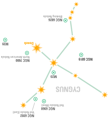
Certainly looks as if Scotland was the place for ancient astronomer/navigators. And what do the two XPI pages have to do with this? Turn the pages upside down, and now consider the Cygnus over Scotland map, and the Mound of Creation with its Ibis head, now becomes the Orkney Islands. Holy Island is Albireo, the head of the Cygnus Constellation. The Druid’s head on the Lindisfarne page has his beard flowing toward the south west, the direction of Sunset of the Winter Solstice. The head on the Kells page is facing west, the direction of Sunset on the Equinoxes. Seems those monks who made these pages, must have been aware of this lovely piece of geodesy, and they left us a record of those times, which occurred thousands of years before they were born. St. Columba, of Druid heritage, was at Iona, and seems to have built a very early church at Dunkeld. The later medieval Cathedral there was dedicated to St. Columba. With his background, he may have known about this geodesy. Iona was a Druid mystics’ retreat long before Christianity.

Were the people at Brodgar Druids? At the moment it isn’t known, but it is believed that there was an elite priesthood there. One which was certainly concerned with astronomy. Much artwork has been found there, although I have only seen the Brodgar Eye. One building had a stone with eight rows of lozenges, another had a cist in the floor covered by a triangular stone. It was situated in such a way, that you would have to walk over it. There are also other markings there, which by the description could be Ogham. Perhaps I can get some pictures, that is if I can get any answers from the archaeologists. One can only hope at the moment, but the Brodgar Eye and the Akhet, do point to Egyptian connections, even the monks made the head of the Mound of Creation, the head of an Ibis. As far as I know, there is only one connection to an Ibis, and that’s Thoth in Egypt.

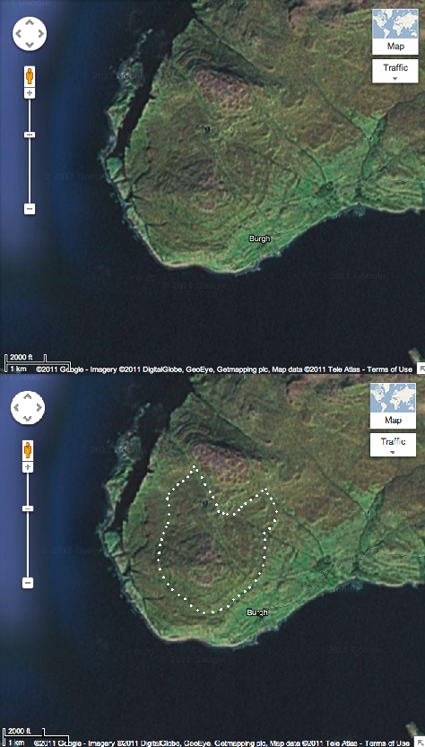
Derek Cunningham made many interesting discoveries, but one in particular caught my eye. A spiral hill on Iona, I outlined what I could see there. Hmmm………The Horned Man? Or does this actually mean something else?

Among the contents of a Hittite sign list, I found a symbol for, propheta. This word is in Luwian, a language connected to Wilusa, which is where the city of Troy was. Propheta is self-explanatory, prophet, in other words. But a prophet in ancient times, probably started out as an astronomer/astrologer. They made prophesies using the Sun, Moon, planets, constellations and other stars. What he has on his head is a sort of turban with long tails, which explains the head-gear being worn by the men on the two XPI pages, and likely this head on the landscape of Iona. As I said, Iona was a Druid mystics’ retreat long ago. Mystics are often prophets. If this head is as old as many of the other geoglyphs, then the people at Brodgar likely were Druids. They were at Silbury Hill c2500 BCE.

References

Midnight Science Journal, papers by Derek Cunningham

Orkneyjar, postings by Sigurd Towrie

Dunkeld, Wikipedia

Pictures

XPI pages from the Book of Kells, the Lindisfarne Gospels and the Doggerland map, Wikipedia.

Map of Cygnus over Scotland, World line map, and the spiral hill on Iona, Midnight Science Journal, papers by Derek Cunningham. Cygnus over Scotland on an Ordinance survey map. World map from Mapquest. Iona spiral hill from Google-Imagery

Propheta from Hittite Sign List pdf. author Gunter Anders

Cygnus map, starrynighteducation.com, Oaklands Astronomy Club

Orkney Venus, carvings at Holm of Papa Westray, the Brodgar Eye, picture of excavation at Brodgar, picture of the Akhet stone, the stone dresser at Skara Brae, and the magnetometry scan from Orkneyjar, posted by Sigurd Towrie

Folkton Drums, Ancient Celtic New Zealand.
The Mold Gold Cape

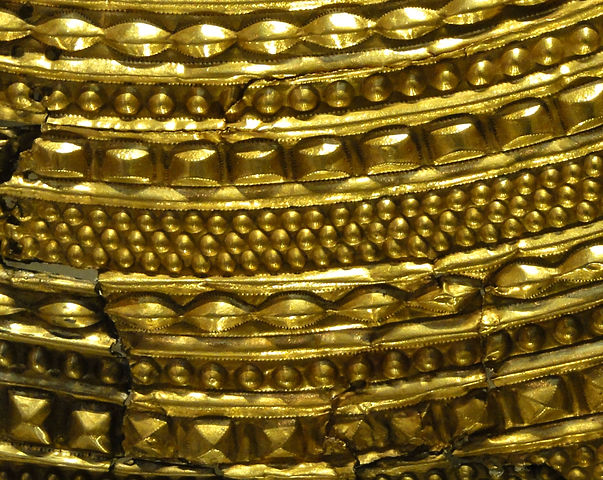
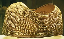
The beautiful Mold Gold Cape is certainly worth having another look at. This wonderful article was found in 1833 by workmen quarrying for stone when they came upon a stone cist. They had been digging in a burial mound named Bryn yr Ellylon, the Ghost or Goblins’ Hill near Mold, Wales. The person in the cist was wearing the cape. Unfortunately the skeletal remains were fragmentary and the cape crushed and broken into several pieces. Many pieces were removed by various people, and it took many years to gather as much as possible.

At first it was thought to have been a corselet or breast plate which passed beneath the arms, but by 1904 the British Museum was presenting it as a chest ornament for a pony. By 1950, it was finally suggested that it could be a cape. Another fifty two years went by before all the pieces had been put together, which proved that it was a cape. A cape which would only have fitted a slight person, thought to have been a woman. No weapons, axe, mace, ‘wrist guards’ or other male accoutrements were found with this person.

                                                                             The Amazing Detail

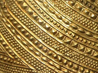
The cape was made out of a single ingot of gold, which was then decorated with rows and rows of different shapes. It looks rather like strands of beads between folds of cloth. The motifs have both Continental and indigenous roots. Some similar designs have been found in France, which are believed to have drawn on designs from central Europe. The lenticular bosses have been found on bronze spacer plates for a necklace  in Migdale, Scotland, and on a bronze armlet from Melfort, Scotland. This motif, surrounded by fine dots outlining the shape, seems to have been used in Scotland for some time, and appears to be part of the indigenous repertoire. This cape is unlike anything found from that time period, or any other period. The craftsman was an exceptional goldsmith, with an impressive artistic flair. It must have made a huge impression on all those who saw this object. At that time, 1900-1600 BCE, it is estimated that there may have only been fifty bronze daggers in all of the UK and Ireland. So most folks were still using stone tools, while this person was walking about with a gold cape.
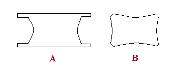
I think of these shapes as houses (large domes); seeds (small domes); lenticular shapes (beans); pyramid shapes ( temples?); rectangular shapes (metal ingots). However, the most standard shape of ingots in ancient times is shown in fig. A. A hieroglyph from Urartu, an Iron Age kingdom around Lake Van and Lake Urmia, looks more like fig. B. So perhaps these shapes are meant to be ingots of metal.

It is believed that this very wealthy person may have had connections to the Great Orme copper mine, which was the biggest copper mine in Europe at that time. Who and what was this person? Queen? Priestess? The Oracle? “Oracles are best in the defence”, says the side of the Queen Stone which points in the direction of  North Wales. The Neolithic house below, named Cul a Bhail, was found on Jura, an island off the west coast  of Scotland. It is very much like a tholos, although they were more dome shaped. But different materials sometimes make for a slightly different shape. The tholoi on Cyprus had stone foundations and mud brick domes, and in Mesopotamia they were made from mud brick. The mud brick was plastered over with adobe, while this house was made of stone, wood and thatch but the basic idea is the same.
                                                                            Cul a Bhail, Jura

There were bronze straps, other flat pieces of gold work, and 200 to 300 amber beads found with the cape. The bronze straps are thought to have given the cape extra support. The other gold pieces are a puzzle, no one seems to know what they may have been. It is thought that the cape was lined with leather, and decorated with the amber beads at the neckline and at the bottom. This could have been done all in one step. The amber beads would have covered the holes in the gold around the edges. This article has no designs the same as those found on the treasures from Bush Barrow, Golden Barrow, or Clandon Barrow. Although it has been dated 1900-1600 BCE just like Bush Barrow and the others, it isn’t known whether the same person made this cape.

I did find a similar design element on a Vinca bowl, which is quite a bit older than the cape. Possibly older by 2000 years. However, this is quite interesting due to the fact that Ogham has many of the same symbols which are found among Vinca or Old European script.                                                                            Vinca bowl

 Vinca or Old European script with Ogham symbols underlined with red.  The people of the Vinca culture are the oldest metallurgists to date. Their culture seems to have come to an end around 3200 BCE, more or less pushed out by other Indo-Europeans migrating in, at which time many of these people migrated to other places. Vinca territory included Serbia, and parts of Romania, Bulgaria, Bosnia, Montenegro, Macedonia and Greece. The Varna culture, also in that area and closer to the Black Sea, was not far from Vinca territory, and they were making gold ornaments in 5000 BCE. There were so many ornaments that archaeologists came to the conclusion that these were very common, everyday decorations, since they were found all over the settlements, and not just in graves. This whole area eventually became Thrace. The Thracians were well known for their beautiful metal work. The following map shows the dispersal pattern of the Vinca in green. Their artefacts have been found as far away as France. And perhaps Wales?

There are several reasons for this theory. The biggest copper mine in Europe was at the Great Orme in Wales at the time when the cape was made. Ogham uses many Vinca symbols. The Vinca spoke a Proto-Indo-European language, wherein W and Y were used both as vowels and consonants. This is also why the Welsh language seems full of consonants, but W is pronounced oo or eu in Welsh, and Y is usually pronounced as I. This makes a word such as Llwyd seem so impossible to say. Ll also has its own pronunciation which is impossible to describe on paper. The last piece of this theory has to do with Y haplogroup E1b1b1, it is one of the unusual varieties in the British Isles, and is said to have spread from the Balkans, which is where the Vinca culture was. In the North Wales town of Abergele, 33% of the men tested, carried this DNA.

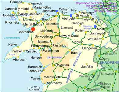
The three blue squares are at Mold, Abergele and the Great Orme. Abergele is closer to the copper mine than Mold is. Did some of the Vinca make it to Wales, take up mining copper, and become wealthy enough to have the gold cape made?

The picture above shows a painted Vinca vase, the date is not given, but would be before 3200 BCE, and possibly a thousand years older. It has a design made like an M, but it is actually two separate pieces which make up this M. It’s more like a 7 and a backward 7. This sign can be found several times in the script, used several different ways. In this case there is a face above the V. It looks like the Akhet again. The Sun between two mountain peaks. Looks very much like the Akhet on the Folkton Drums. The Balkans are named Old Europe, it had settlements of 2500 people and more, a thousand years before such things show up in Mesopotamia, unless the dates for that area are incorrect. This was a well organized society with orderly villages, farming, fishing, gathering and hunting. There seems to have been enough surplus food so that people had extra time for pottery, weaving, mining and metallurgy. Their religion was based on the Mother Goddess, the Earth and her attendant the Bull/Sun God. That isn’t all that different from Celtic religion with its Triple Goddess, the Earth, and Cernunnos, her stag/man/Sun consort. The bull has been an important symbol since very ancient times. Some of the oldest ‘cult’ figures were small stone bulls made at Mureybet. It figures heavily in Celtic art. The Vinca culture was already a well developed society by 5000 BCE, and may be at the root of all later higher civilizations, such as Sumer, Egypt and Crete. Then again, we haven’t seen everything which will be excavated at Gobekli Tepe as yet. Their stone carving was very advanced for 9000 BCE.

Archaeology is full of puzzles and amazing finds, which are changing our view of the people in ancient times. Thanks to modern technology, anyone can scan the earth for geoglyphs, odd formations, see the different colours in fields, indicating buildings, tumuli, roads, etc. Or they can look at the ocean floor, and spot ancient flooded settlements, old coastlines, ancient lakes and rivers, and sometimes find things which look like roads. It’s a fascinating world, I just wish we knew more about it.

References and Pictures

Gold Mold Cape; The British Museum, Wrexham Museum, Wikipedia

Old Europe by Philip Coppens

Vinca Culture; Projekat Rastko: and Professor Nenad Tasic about Vinca and world archaeology, from examiner.com

Vinca footed bowl and article, Internet Library of Serbian Culture: Archaeology.

Vinca vase from Oracle ThinkQuest

Vinca Culture, Wikipedia

Vinca symbols, Wikipedia

Old Europe (archaeology) Wikipedia

Map of Neolithic expansion, Wikipedia

Genetic History of the British Isles, Wikipedia

Proto-Indo-European-Language, Wikipedia

House on Jura, theisleofjura.co.uk

Map of North Wales, touristnet.uk.com

A Disease?

                                                                         Ancestor

History, even ancient history, brings us stories about disease. Since recorded history we have been able to look back at many outbreaks of various virulent diseases. The records of such things in really ancient history are much scarcer. In fact, the field is narrowed considerably by the time we reach c2000 BCE. Most of these stories come from religious texts, where we can read about all sorts of afflictions which hit various people at different times. These events are generally put down to, God’s wrath.

Some of them have been looked at carefully by experts. One army seems to have been decimated through their contact with mice. The experts think that the place they were camped at was over run by mice, and that the soldiers picked up a deadly disease because of it. But this incidence was interpreted in the religious text as God’s wrath. Obviously no one knew just exactly what happened, other than the enemy’s army was practically wiped out. Must have been God’s wrath, said the recorders of this event. We can forgive their ignorance since the answer was quite technical and needed a microscope among other things. But it could always be argued that the mice were God’s wrath.

There’s a story in the Irish mythologies which also tells of one group of people who died “all in the space of one day”. No doubt a bit of an exaggeration, but the point being that the people became ill and died soon after. All of them, which is likely also an exaggeration, but obviously took a large percentage of the population. After all, if they all died, who would be left to tell the tale? This story comes to us through Fintan, the Ancient White One. He recounts the history of the different groups of people who went to Ireland in ancient times. One whole group of people became ill and died. God’s wrath didn’t come into it at all, not even the monks added that. In fact, no reason for their illness is given at all. There was no moralizing about their life style, nor anything negative connected to the story of these people. This is also about the only time that you read about such a thing happening in the Irish mythologies. Obviously a large event which made a lasting impression.

The question is, would rulers of city states in ancient times have allowed their scribes to record such events, or did they just stick to recording religious rites, trade, battles, treaties, marriages, deaths, etc.? It wouldn’t be good for trade if you let on there was a problem. No ruler was going to admit publicly, that he was out of favour with God or the gods. The population would make up its own mind about that. For instance, did the Egyptians record the various things which befell them during the time of Moses? It would seem not, since the experts still don’t know whether Moses really existed , never mind which Pharaoh was ruler at that supposed time. So far there has been nothing found in Egyptian records about these events.

Most ancient societies seem to have been heavily influenced by their belief in God or the gods. Any city-state or country to suffer a great loss of life through disease would have been believed to have been cursed by God or the gods. It’s not likely that the rulers of such places would record such a thing. Anyone among the educated and craftsmen would have abandoned the place if they could. No one would want to live in a place that was cursed. No one would want to live in a place where people were dying wholesale of a disease. The peasants and poor would have been left behind and likely died. This is what has always happened throughout history. It was always the educated, affluent and talented that were  the most mobile, the poor generally stayed in place.

It isn’t likely that the people leaving would tell their sorry tale when they got to wherever they were going. If they settled in a new community, it isn’t likely that they would tell people that they had come from a place that was cursed. Nor would they have mentioned disease and people dying of that disease. They would have been shunned by the people in their new chosen community. If this new group of people had found out what had happened, and anything bad happened in their territory, the new comers would have been blamed. It wouldn’t matter if the disease was different or if it was the sheep that were ill and dying, the newcomers would still have been blamed. It isn’t that long ago that there were actual witch hunts. Sometimes over nothing more than a bad crop or a sick cow.

After reading a great deal of history, it became  obvious that something quite out of the ordinary happened c3200 BCE. Something which seems to have changed a great many things. It has been estimated that Mesopotamia lost about sixty thousand of its citizens. Uruk was the only city to gain in population, but all the other big cities like Ur and Eridu, as well as the countryside, seem to have lost people. Some have attributed this sudden decline in population to the dispersal after the Tower of Babel incident. No famine, weather or war details seem to account for this. Suddenly, all sorts of new constructions in many different places took place. Civilizations, fully functional, with every sort of craft, astronomers, priests, kings, scribes, smiths, architects, farmers, etc. pops up in places which saw nothing but hunter- gatherers and homestead farmers before that. All of them under unexplained circumstances, leaving us wondering, why then? What caused this sudden explosion of seeming knowledge of building, etc.? Why does there seem to have been mass movements of people? Apart from the Tower of Babel, disease could be the answer.

The Feudal System came to a crashing halt after the plague took hold of Europe. If there is little recorded history of those times in five thousand years, will archaeologists be left scratching their heads then also? What will they make of the remains in the plague pits were people were buried by the hundreds? Will they think disease or massacre? Such mass graves exist also. Or will they come across a few records mentioning this disease, and then think the masses of dead were victims of human sacrifice? Knowing what we know makes this sound illogical, but if you had nothing to go by but a few scraps of paper here and  there, if any survived, and then you found one of those plague pits…………………? One of the current ideas is that Stonehenge was a Temple of death, will archaeologists think that of Westminster Abbey or St. Paul’s Cathedral? After all, there are a great many people buried within them.

We can only see through a glass darkly in the field of ancient history. Our knowledge of them is miniscule compared to the vibrant life such city states must have embodied.   All that is left are fragments of cities, bones, weapons, pottery and some spectacular treasures, by which these places have been dated. Experts debate about the meaning of carvings, wall paintings, sculpture,  ancient religions, etc. There are more opinions out there than there are artefacts. Opinions also change, some of what was believed in the 1800s is now considered archaic.

The Mold Gold Cape is one of the most outstanding sheet gold artefacts which has been found. It is unique, in a class of its own, and nothing like it has been found anywhere else in the world. It was hammered out of one ingot of gold. Found broken and in fragments at Bryn yr Ellylon near Mold, Flintshire, Wales in 1830, it was first thought to have been a corselet or breast-plate which passed under the arms. In 1904 the British Museum was presenting it as a chest ornament for a pony. It wasn’t until 1950 that its form suggested that it was a cape, and it wasn’t until 2002 that all the missing pieces were put together, proving that it was a cape. It is dated 1900-1600 BCE, and it is not known whether this was buried with a man or a woman. However, since it is only 18 inches wide, it is thought to have been a woman. Some 200 to 300 hundred amber beads were also found, presumably part of the decoration of the cape. Only one bead remains in the British Museum.

Although we can admire the amazing artistry which went into creating this cape, it tells us next to nothing about the society this person lived in, except that there was a certain amount of wealth, and that it was likely connected to the Great Orme copper mine. It tells us nothing about the person who wore this cape, only that she must have been important. How then can we try to interpret these people’s motives for doing certain things? Like seemingly abandoning one area of the globe, after which ‘civilization’ comes fully formed in other parts, when there is no concrete evidence to show us why this occurred.

Ancestor by Susan Seddon Boulet

The Mold Gold Cape, The British Museum

The Golden Barrow Treasures

The Golden Barrow or Upton Lovell G2e was near the River Wylye, slightly South West of Stonehenge. Since its excavation in 1803, it has been destroyed. This barrow contained as  many costly and interesting treasures as the Bush Barrow. There was more than one cremation found in this barrow, but the treasures only seem to have been with one person. It isn’t known whether this was a man or a woman, since necklaces may have been worn by anyone. On the other hand, the Wessex lord in the Bush Barrow had no necklaces with him, nor did the Amesbury Archer, nor his family member, who may have been his son. He also had gold ‘hair tresses’. Perhaps this particular person was a woman.

William Cunnington had the following to say about this barrow.

“TUMULUS XX (AW 98) Copy of a letter to H. P. Wyndham Esq July 28th 1803

Sir I have this day opened a barrow in Upton Lovell it is situated in the meads a few yards north of the river Wylye. As the discoveries in this barrow are more important in their nature than any other ever yet made I hasten to inform you the particulars. This Barrow of a pyramidal form or rather like the common houses, pointing East to West, is in the base 52 by 32 feet, the slope 22 feet, the length on top 22 feet. The North side of the barrow is extremely ? the south side is much mutilated. On making a section lengthways of the barrow, at about two feet deep we found in a very shallow cist human burnt bones piled in a little heap, and at a foots distance a considerable quantity of ashes, which also contained small fragments of human bones, upon which and at two feet distant from the bones were found the following articles of pure gold, which are neatly wrought and highly polished, viz about ten gold beads* made in the form of a drum ? two ends to ……off and perforated in the sides…see Plate XI fig 5…….. a thin plate of the same metal…….nearly 9 inches by 6 inches long, this is very neatly ornamented as you will see by plate XI fig ?………by a beautiful Bulla of conical form, see figure 3 in the same plate- and inside this is a solid cone of wood, the gold which completely covered it is very thin, at the base are two holes for a thread or wire by which it was suspended see fig 4. near the above were found of four gold articles viz.. two of which that appeared once to have covered the ends of staffs (some of my friends say they are small boxes. see plate XI fig 1 and 2. Among the gold ornaments lay several flat pieces of amber, about the eighth of an inch in thickness, and about an inch wide, -they were all perforated lengthways but were sadly broken in getting out. ( see plate two fig 2 when joined they were the exact form of those found in Deverell Barrow only bigger). What is very extraordinary there were also nearly one thousand  amber beads of different sizes see Plat X fig 2. – Close to the pile of ashes we found a very small urn see Plate X fig 1. Also a lance head of brass and a pin of the same metal-see the same plate. The urn is of very extraordinary form, appearing as though it had been studded all over with small black grapes. In this barrow, contrary to the usual custom of interment on the Downs, which is generally on, or in the native soil we found the cist nearly on top of the barrow and this deviation was probably occasioned by the wetness of the soil, the barrow being near the river. We find in other respects a similar method of internment to what we find in many other barrows, the small urn, lance head of brass, brass pin etc are common. From the profusion of valuable ornaments, for valuable they must have been at the period of their internment, we might naturally conclude this barrow to have been the sepulchre of a great chief of the Belgic + Britons. +Mr. Coxe objects to the word Belgic, suppose we say British chief near the time of Caesars invasion.” (1)

Shale and amber beads, and the shale core of the gold covered  button

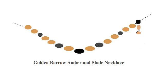
William Cunnington was a wee bit off with his dates, since it is now thought that the cremation dates 1900-1600 BCE, but like Bush Barrow, it could be older.  The gold artefacts from both barrows do look as if the same person made them. At the Wiltshire Heritage Museum, the bronze lance head is listed as a knife dagger, and the bronze pin is listed as an awl. The above amber and shale beads are believed to have been a necklace.

The gold beads, which were drum shaped, approximately 1/2 an inch long, had ends which could be screwed off, they were small containers, and could be opened even while being worn, perhaps as part of a bracelet, with the gold button used as a fastener. The button would have been on the outside of the arm. This fancy button is gold  foil over shale, named a Bulla by William Cunnington, and has holes drilled in a shallow V shape in the bottom. The measurements given for the gold cover are 47 mm in diameter and 43 mm in height.

Gold beads from the Golden Barrow

Gold Button showing top and undersideHow the bracelet may have looked and the method of tying it together.

Once the ends of the cord went through the button, it wouldn’t have to be removed again. It would be untied and loosened when removing it from your arm, but the end of the cord would stay through both holes. These ends may have been decorated with long hair from a cow’s tail, feathers or perhaps some of the amber beads which were found. Bracelets of this general form were commonly seen on the carvings of rulers from Sumer, Babylon, and Assyria. The ones from the area of the Fertile Crescent, usually had a flower on them. The button has the same triangle or zigzag decoration as was found on the large gold lozenge from the Bush Barrow. But the button has an extra surprise. On the bottom the design is the same as the central part of the Clandon Barrow lozenge, which was another device connected to mathematical coding as shown by Martin Doutré. This lozenge must also have been made by the same person.

The Clandon Barrow lozenge construction as drawn by Anthony Johnson

These mathematical codes were quite complicated, and were connected to astronomy, surveying, navigation, calendar keeping, weights, measures and volumes. The various articles which were inscribed with these codes, would have been used as memory devices. A question from a fellow blogger, made me investigate the Rillaton and Ringlemere cups a little closer. These were found at two different places and not with the Golden Barrow treasure.

The Rillaton cup (left) is 9 cm high, and the Ringlemere cup (right) is 11 cm high. One of my measuring cups looks to be about the same size as the Rillaton cup, only a little taller. 9 cm up the side of my cup gives me one pint. These cups may not have been for drinking beverages, instead they may have been measuring cups for some other purpose. The Ringlemere cup may have a pint capacity at the top of the corrugations, and perhaps another measurement when full. It may have held three cups when full. The corrugations likely indicated different measures, both dry and liquid.

A pint is an interesting measure since it can be found in both dry and liquid Imperial measure. Liquid measure: 4 gills = 1 pint; 2 pints = 1 quart; 4 quarts = 1 gallon; 1 gallon = 231 cubic inches. Dry measure: 2 pints = 1 quart; 8 quarts = 1 peck; 4 pecks = 1 bushel; 10 pecks or 2 1/2 bushels = 1 barrel; 1 bushel = 2150.42 cubic inches. Thinking of the other mathematical codes found in the other gold objects, makes me wonder what measurements could be found in each groove of the corrugations. I don’t suppose the British Museum would allow me to conduct an investigation, unfortunately.

The handles on these cups are held to the body by lozenge-shaped rivets. The way they are attached makes them look like small Squares of Enlightenment. These lozenges, zigzags, and triangles are all little signatures of a highly evolved system of weights and measures. All these systems stem from astronomy, and do seem to have been around for thousands of years before we see the proof of such things in the UK and Ireland. However, these people may have used wood, stone, pottery or some other material for their original measuring devices. A piece of simple cord could have had knots tied in it at the appropriate places. It would be small, light and easy to carry around, but such things in the UK and Ireland would have decayed long ago. It’s obvious that whoever made these gold artefacts, had some sort of measuring device, and knew all the mathematical coding. The people using them would also have understood the coding, which means that we are looking at some very well educated people. The mathematics involved are really quite astounding.

Because these artefacts do all seem to be connected to measures of all sorts, based originally on the circumference of the Earth, it is quite possible that the cups, the Clandon Barrow treasure, the Bush Barrow Treasure, and the Golden Barrow treasure were all made by the same craftsman. I don’t imagine there were that many goldsmiths running about in those days who would have all this knowledge. In ancient times smiths were considered holy because they used the four ancient elements of Earth, Air, Fire and Water to make their artistic creations. In Egypt they were a priesthood, they were the magicians who could turn a solid substance into a liquid, and then reshape the hardened metal into whatever shape they wanted. The biggest percentage of the population would still have been using stone tools, so these ‘ornaments’ must have been mind-boggling for anyone who saw them. The Amesbury Archer being the foremost candidate as craftsman, since he had the gold ‘hair tresses’, the metal working kit, and the ‘wrist guards’ which were actually measuring devices. Perhaps the hair tresses were a sign of their profession.

Getting back to these interesting gold beads, they had me wondering what was kept in the containers. What were they for? What use did they have? They were strung together through two holes in the sides rather than two holes through the ends, which would have made it possible to separate one from its companions to be able to undo one of the lids, but why? I had several thoughts about this. Perhaps special powders were kept in them for creating green smoke, red smoke or sparkles when applied to a fire. Done on the sly of course, the peasants wouldn’t have known that there were special powders hiding in the bracelet. Such things were generally done after dark, so the only light may have been the fire.

But then I thought perhaps this person was keeping track of different women’s pregnancies. One container per person, and after each month went by, you would add a grain seed or perhaps a small piece of gravel. Questions would have been asked to determine which phase of the Moon, and how long ago this person thought they became pregnant. However, it is also possible that they were keeping track of different weights belonging to various systems. Wheat seeds were once at the root of weight measures. This is why we still have, grains, as a weight measure. Among the Hebrew desert weight (light) measures  can be found 131.25 grains. Having some wheat seed on hand, I did a little experiment. Each one of these gold containers could hold 12 wheat seeds, making a total of 132 if all the containers held 12 each. This bracelet now becomes a great deal more than just jewellery. The button likely had measures in its size and decorations. Drawing a triangle with base 47 cm and height 43 cm, pretty much gives you an equilateral triangle. The central mathematical codes of the Clandon Barrow lozenge are also on the bottom of the button. Considering what else has been discovered, coloured smoke seems rather lame. But who knows? These people were into dual purpose things.


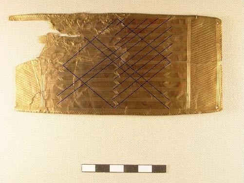
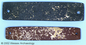
The next piece is a gold plaque 144 mm by 68 mm, according to the Wiltshire Heritage Museum. It once had a wood back as did the two large gold lozenges. I’ve been stringing lines on it out of curiosity. The large lozenge has angles of 80° and 100°, these are the same as the large gold lozenge from the Bush Barrow. This area may have been connected to Solar/Lunar measurements. The tiny lozenges in the net at each end of the plaque have angles of 60° and 120°, which is what the small gold lozenge from the Bush Barrow had. This net is reminiscent of the lozenges I strung across England, which had to do with surveying. As a final bonus it has cording around the edge, the measuring cord. If the museum’s measurements are correct, then the circumference of the plaque would be 424 mm or 42.4 cm. 10 cm = 4 inches. So the circumference would be 16.96 inches. Dividing 16.96 by the magic number of hidden secrets, 4, I get 4.24 inches, which is a reflection and progression of 424 mm and 42.4 cm. This is the magic of metrology, all numbers in all systems are interconnected, having stemmed from one source, the Great Pyramid, which many consider to be much older than Khufu, who is supposed to have had it built.

Although I am not a mathematician, I’d say this gold plaque is likely full of mathematical coding, just like the gold lozenges. Seems these gold artefacts were more than mere jewellery, they were memory devices covering a wide range of measurements of all types. Being made of gold, they wouldn’t rot, their hidden knowledge has been there all the time, but few people have recognized their significance, thinking of them just as ornaments instead. Considering their function, they may be much older than Bush Barrow or Golden Barrow. They could well have been heirlooms when they were finally buried, possibly dating back to before 2300 BCE.  These articles may have been the ‘gold standard’, literally, of measurements in England at that time. They may have been used by the elite to keep an eye on the merchants’ measures, to make sure they were not short-changing the common folk. The Bell Beakers may have become so popular because they may have held a certain capacity or capacities, and became a common man’s measuring device all over Europe.

Two conical bosses and two flat pommels were found also. These were first interpreted by Sir Richard Colt-Hoare as small boxes, but William Cunnington found them several inches apart, suggesting they were the ends of two wooden sceptres. Unfortunately it doesn’t tell us how long these sceptres may have been. They may have been measuring rods, rather than just sceptres. This would be in keeping with the other measuring devices.

This last piece is quite fascinating. It is thought to have been an incense burner. Although several incense burners have been found in various barrows, this one is unique. There are 108 small knobs, which seem to have been applied to the pottery one by one. There were holes drilled into the pottery between these nodules. It’s rather made like a net.

All in all, these treasures are quite amazing, particularly all the mathematical coding found in these pieces. They must have been incredibly costly at that stage in history. Such gold instruments would be extremely costly now, even the lunula shaped amber necklace would cost a fortune today. Who were the people who owned these items? Have we stumbled upon the people named the Tuatha Danann? Were they the people of the goddess Anu, D’Anu, or should that be the god Anu, or his wife Antu? The Abantu of South Africa are Ab Antu, the children of Antu. D’Anu in Sumerian would mean, of Anu. This puts us back with Anu’s White Temple and Inanna’s Temple in Uruk. The artefacts from England that we have been looking at had the same design elements as the cone mosaics at Inanna’s Temple.  It’s all those names, Danann, Manannan, Inanna. The earliest form of Bran the Blessed’s name was Uran, which became Vran, and then Bran. Uran from Ur or Uruk? I am not through investigating these gold artefacts, and am making further enquiries regarding these. I will post my findings at a later date……….I hope.

References and pictures

For anyone interested in the mathematics which has been found at Stonehenge and on the Bush Barrow and Clandon Barrow lozenges, see Martin Doutré’s work at Ancient Celtic New Zealand, and D. P. Gregg’s, The Stonehenge Codes, which is in PDF form, so you can download it and read it at your leisure, it will take a while. For other measurements of various landmarks, megaliths, and ancient constructions in many countries, see Ancient-wisdom.co.uk. This is an excellent site with clear concise facts and plenty of detail and great pictures.

(1) William Cunnington, Manuscript Letters, Vol., p.35-6

Wiltshire Heritage Museum, articles and pictures of the Golden Barrow treasures, listed as Upton Lovell G2e.

British Museum, the Rillaton and Ringlemere cups

Drawing of the Clandon Barrow lozenge construction method, Anthony Johnson, at Wikipedia entitled Clandon Barrow.

Drawings of the amber and shale necklace, and the gold bracelet, J. Rankin

The Bush Barrow Treasures

The history of the Neolithic-Early Bronze Ages in Great Britain and Ireland are akin to a blank piece of paper, with here and there a dot, a dash, a thumb print, some mud streaks and even some jam. But all these things tell us almost nothing about the people, their society, their way of life, their religious beliefs, or their ancient history. If it wasn’t for the fact that they left megalithic constructions, pottery, and barrow cemeteries, we’d know almost nothing about them at all. But even those only give us a tiny glimpse of their lives. How did they view these things, what all took place at stone circles, henges, long barrows and places like Newgrange and Maes Howe? What traditions, histories and knowledge did they bring, and from how many diverse places? What gods and goddesses did they follow, and did they create a whole new religion in the Isles, one which incorporated many of their shared ideas?

The DNA of both the hunter gatherers and the farmers, comes from the Continent. Before c6200 BCE, people could wander, from what is now the Continent, right into England. Not only was Doggerland still there, but the channels of water between the Continent and England, and Ireland and England were much narrower then. If you wanted to sail across, it wouldn’t have been as far as it is today. All coastal areas around the world have lost ground, are still losing ground. Settlements have been found off the coast of Spain, Iraq, India, in the Dardanelles, and in the Black Sea. There are theories which state that the Mediterranean may have been mostly dry during the last Ice Age, and that the Black Sea was once a fresh water lake. This would have made wandering from one area to another much easier.


The map on the left shows what Europe may have looked like before Doggerland disappeared. The black line is the St. Michael’s Ley. The map on the right shows the distribution of Beaker pottery.

In the Isles we find a mix of ancient DNA from the Iberian Peninsula, Greece, North Africa, the Fertile Crescent, the Caucasus, the Eastern Mediterranean, and the Balkans. The oldest matrilineal DNA comes from the area of Delphi, Greece, which entered England and Ireland c7300 BCE with the hunter gatherers. In Ireland this DNA is fairly evenly distributed. Jasmine and Tara hailed from the Fertile Crescent and the Caucasus. These are the two matrilineal lines connected to herding and crop growing, and some of them may have come with the Cardium pottery people, since they are also connected to the spread of farming. Their earliest pottery c6500 BCE was found on Corfu, which was connected to mythologies about Poseidon, god of the Sea.

Corfu is also on the Apollo-St. Michael Line, which runs from Mount Carmel to Skellig Michel in Ireland.  Cardium pottery and Jasmine’s descendents were found on Mount Carmel, the end of the line, or the beginning. This line was important for several thousand years. Christian pilgrims still follow this line from Mont St. Michel, France, to the Holy Land. In ancient times it was used going in both directions, not only for trade, but also to obtain fibrolite and jadeite from the Ligurian Alps, to make polished axes. These do seem to have been ritual objects, since they usually show no sign of having been used as a tool. There are several mountain passes in Northern Italy which lead into France and Switzerland. The San Bernardo Pass is on the line, and has a stone circle right on the pass, which today is halved by a road going through the centre one way, and the border between France and Italy splits it in two the other way.


As can be seen on the above map, early megalithic culture seems to have been spread by sailing.

By the time the Windmill Hill people entered the UK and Ireland, they already had several backgrounds among them. Until recently, it was thought that all the megalithic building was done by the Beaker people, but now it seems that much of it was already built before Beaker pottery came along, including most of Stonehenge. The Beaker people left many question marks. Were they a distinct culture, or did their pottery just become very popular? With them comes an assemblage, consisting of Beaker pottery, stone ‘wrist guards’, metal working, and round barrows. Their knives were similar in style to Egyptian ones. The exact root of these people is still being debated. The Iberian Peninsula or the Rhineland? Or were they a people at all? Or did this assemblage just become part of new innovations? Some of the movement was by land, and some was by sea.


                                                                 Amesbury Archer’s wrist guards

Although there is no sign of a full-scale migration of Beaker Folk, there does seem to have been a new lot of people who came to England c2400 BCE. The Amesbury Archer being an example, he grew up in the area of the Swiss Alps. He’s been dated c2350 BCE. His younger family member had spent his youth in either Wales or Scotland. They were found with gold ‘hair tresses’, these being the oldest gold articles in England to date. He’s been called an archer because he had two stone ‘wrist guards’ and many arrow heads buried with him. But he also had a metal working kit with him. Whether these stone objects were in fact wrist guards is debatable. About a hundred of these have been found in the UK and Ireland. Most have some holes drilled in them, which would allow you to tie it to your wrist, but for archery these would be useless, since the bow-string would catch on either the stone or the fastener. One theory put forward by Martin Doutré, is that they were a measuring device. This seems more logical, since there is one with all the holes filled with gold foil. They also have some edges which are tapered, and I wondered if they were for resting your hand on when writing. There was such a thing as writing by 2400 BCE.


The above symbols were found around the Black Sea area and belong to the Vinca Culture, they date c4000 BCE. What struck me is that the top ones resemble Ogham, which was also written in different ways. The most common is the straight lines, but it was also written as dots on a line, resembling beads of a necklace. I’ve also seen the comb shapes used. Usually the top line and the two outside ones became the frame, the lines in between were the letters, which is slightly different from this version. Since this already existed in 4000 BCE, it wouldn’t be impossible for another version of this to show up in the UK and Ireland by the time the first part of Stonehenge was built, since some of the ancient DNA did have connections to that area.

I’ve read about several of the burials connected to wrist guards, for the most part these men were said to be tall. The Wessex lord in the Bush Barrow was also a tall man, over six feet, making the archaeologist remark that he would have been much taller than his contemporaries. Although he had no wrist guard, his treasures are among the most important from that time period. Bryan Sykes names the Windmill Hill people, the little dark people. This was certainly still true of my grandfather who could have fit in anywhere in the Middle East. His grandmother’s matrilineal DNA came from Jasmine. This great great grandmother  was a small dark-haired woman from Llanrwst, North Wales. I’m surrounded by Celts of both Irish and Scottish descent, most of the Scots came from the Highlands and Islands, and the little dark people are still alive and well among both groups today.

The next oldest gold objects in Britain are the Rillaton and Ringlemere cups. They’ve been dated c2300 BCE, according to the burials they were found with. At first archaeologists thought that they may have been votive offerings and dated them c1650-1400 BCE because of a much plainer cup found in Mycenae which came from one of the grave shafts. Only five other such cups have been found on the Continent, all have been dated c1700-1500 BCE.


The Rillaton cup and a computer reconstruction of the Ringlemere cup which was damaged by a plough when found.


                                                     Mycenaean Treasure including the corrugated cup.

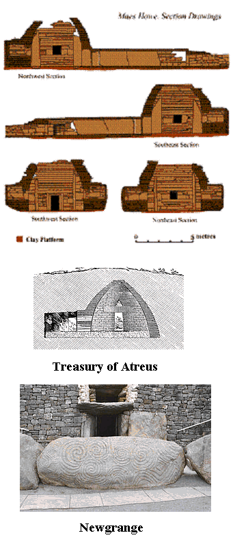
At one point it was taken for granted that all similar objects found in Mycenae and England, were the originals in Mycenae and copies in England. After having a good dig around, I found that most are older in England rather than in Mycenae. The Treasury of Atreus, with its curved lintel over the doorway, wasn’t built until c1250 BCE. The Sarsen Circle at Stonehenge had already been in existence for 1250 years by then. A cross-section of the Treasury of Atreus looks much the same as one of Newgrange, c3150 BCE, or Maes Howe, c2800 BCE, except that the passage  of the Treasury was on the outside rather than on the inside as at the other much older constructions. The Treasury was a tholos, and also had an opening above the doorway reminiscent of the roof boxes at Newgrange and Maes Howe, although archaeologists say that there had been a triangular stone in the opening of the Treasury. Tholoi were already quite old by the time the Treasury was built. The oldest are at Khirakitia, Cyprus, dating to the 6th millennium. These were all houses. The oldest tholoi to be used as tombs were in Oman, and unless the Mycenaean cup was an heirloom when it was buried, the cups in England are older by about six hundred years.


 Cross section of Maes Howe and the Treasury of Atreus, and the roof box at Newgrange

There was contact between Mycenae and England. A typically Mycenaean knife is carved on one of the Sarsen uprights at Stonehenge, along with many representations of bronze axe heads, the same sort that the Wessex lord had with him. The first shipment of amber to arrive in Mycenae was in c1750 BCE. It’s believed to have come from England because the spacer plates were the same as those found in England. The necklace below shows the spacer plates, it came from the Golden Barrow or Upton Lovell G2e.  Bronze double-headed axes from Mycenae appeared in Cornwall and Wessex c1300 BCE. The Boy with the Amber Necklace, who is buried close to Stonehenge, is said to have been from somewhere on the Mediterranean, he’s dated c1350 BCE. Did he come from Mycenae, along with the axes?


The Golden Barrow is contemporary with the Bush Barrow said to be c1900-1600 BCE, although I have seen Bush Barrow pushed back to c2000 BCE. The person in the Golden Barrow was cremated, while the Wessex lord in the Bush Barrow was buried, but the gold artefacts found in both barrows do seem to have been made by the same person. The same design elements were used on both collections.


Gold covered shale button from the Golden Barrow and the large gold lozenge from the Bush Barrow

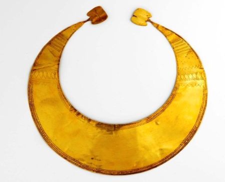
The next gold artefacts to come along are the Lunulae, these gold collars date c22o0-2000 BCE. Most have been found in Ireland, but others have been found in England, Scotland, Wales, France, Belgium, Germany, Zealand and Funen. There is one from Harlyn, Cornwall, two from St. Potan, France and three from Kerivoa, Brittany which were all made by the same person. His tool kit was found, and matched to these artefacts. There was also a partly finish lunula with the tools.


                                                                 Gold Lunula from Ireland

On the Doggerland map, the black line is an approximation of the St. Michael’s Ley, it ends at a long V-shaped channel, where many rivers converged. Good trading place. This could be the area from which the amber in England came from, and Zealand and Funen may be two of the places left from the area with the deep V-shaped channel. Perhaps they traded gold lunulae for amber. Someone in England made the amber necklace which actually looks like a lunula.  Unfortunately, we have no concrete date for either Bush Barrow or the Golden Barrow. Excavating Bush Barrow and getting a sample of the Wessex lord could certainly help to date him. The gold could also be tested, this could give some interesting results. The gold lunula from Tara has been shown to be a calendar device, as was the Wessex lord’s large gold lozenge, among other things.


                                                                         The Tara Lunula

I know that there are those who do not want the burials at Stonehenge to be excavated, but this is keeping back the knowledge which could be gained. These people’s remains and the artefacts which are buried with them, are now the only clues we have to some of this history which has been lost for so long. By the time Bush Barrow and Golden Barrow were created, there were people there referred to as the Wessex Culture. Archaeologists are not sure whether this culture consists of the elite buried in the barrows, or whether this was a combination of all the different cultural groups which had made their way into that area. A new elite seems to have sprung up, or perhaps only a new amount of wealth appears with the burials. Burial practices had moved from cremation in the Aubrey holes c3000 BCE, to inhumation for the Wessex lord c2000 BCE, back to cremation in the Golden Barrow. Only the elite seem to have been buried in the barrows, whether long or round, archaeologists are not sure what became of the common people’s remains.


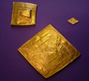
                          The two gold lozenges and gold belt hook from the Bush Barrow.

Can the articles found with these people tell us anything about them or their society? The artefacts that have been found in the Bush Barrow have been called, Britain’s First Crown Jewels, and the gent buried there, The King of Stonehenge. However, this term is now also used for the Amesbury Archer, but he had no crown jewels, only a metal working kit. Perhaps he made the artefacts found in the area of Stonehenge. With the Wessex lord were found two sheet gold lozenges, a sheet gold belt hook, a long lance head, a bronze axe, three bronze daggers, a stone mace head, bronze mounts and zigzag bone rings for the mace handle, and a number of bronze rivets and other pieces of bronze and wood.

The angles of the small lozenge connected it to the surveying angles. Where the St. Michael’s Ley and the Apollo-St. Michael Line cross, they give angles of 60° and 120°. The belt hook is a quadrangle, which may have been representative of the Station Stone quadrangle at Stonehenge. The large gold lozenge could be used as a calendar device as shown by J. Giesen’s Sun and Moon Lozenge Applet, but Martin Doutré found that there were many mathematical codes built into this piece, it wasn’t just an ornament, it had important functions. 

Sun Moon Lozenge Applet

I found the inside lozenge in the surveying of the Aubrey holes (1), which gave the same geometry. It even included the two parallel lines crossing two parallel lines, the Ogham symbol for the hidden secret. This surveying formation was created at Stonehenge c3200-3100 BCE, and I call it the Stonehenge Logo. The symbol for the hidden secret is very fitting on the large lozenge, since there are such important functions connected to it. Such a well-kept secret, that it has taken over four thousand years for people to discover anything important about it. Still, many will say it was nothing more than a piece of jewelry. Yes, well………………………we’ve just been underestimating these ancestors. Their knowledge was much greater than we have given them credit for.


 Head of the bronze dagger showing the rows of tiny pins, and a drawing of what it may have looked like.

One of the daggers is believed to have come from Brittany. Its handle was decorated with a zigzag made up of thousands of tiny gold pins, mounted one by one. The top of the handle was also covered with tiny pins. It is estimated that some 140,000  pins were used. I wondered why the maker hadn’t used a piece of sheet gold to create the zigzag, but realized that each small pin would have reflected light independently, similar to the way sequins do. The zigzag would look as if it were sparkling. Live lightning at his waist. One can only admire the patience and dedication to make such a piece, a princely item for sure. A dagger decorated with pins or studs was also found in one of the royal tombs of Ur, the oldest date c2500 BCE.  The pins in this piece are not as small as the ones in the dagger from Bush Barrow. The triangular piece looks like a pointy hat, I wonder what may have been mounted in the handle just above the point. A piece of lapis lazuli, a ruby, turquoise bead?The blade looks as if it could be opened into a set of…….dividers or a compass. But of course, the channel down the middle of the blade is for the blood. I can still see it opening up into the dividers or a compass though.

Something which ties in with some of the things from Bush Barrow, are the pottery cone mosaics found at Ur, Uruk, and Eridu. These long thin pottery cones were placed in adobe to create mosaics. The following picture shows three pillars which were in Inanna’s temple in Uruk. All these designs can be found on the Bush Barrow treasures. The gold pins were applied to the wood handle of the dagger in the same way as the cones were placed in the adobe. The lozenges inside lozenges are there. The smallest inside lozenge is made up of nine cones, a square three by three, Bab Ilu, the Gate of God, and considering this was at Uruk, that would seem to be correct, since Anu’s White Temple is there also. The small triangles  on one of the pillars can be found on the large gold lozenge, and the button from the Golden Barrow. The zigzag can be found on the dagger handle, and is also present in the bone zigzag rings on the mace handle. The Treasury of Atreus is said to have had two half pillars with zigzag bands around them beside the entrance. They didn’t have to go to England for that inspiration. The cone mosaics date c3300-3100 BCE, right about the time someone surveyed for the Aubrey hole circle.


Apparently such mounts and zigzag rings have been found in France and Mycenae. I have not seen a picture of these, but the ones in France are said to be gold. Here again, we find something which is the same in England as in Mycenae. However, I would say that the ones in England are the oldest, and that there was something significant about the bone rings. The Wessex lord could surely have afforded gold ones if he wanted them. The small gold lozenge is believed to have been attached to the handle of the mace. This piece may have been an heirloom when buried, and had some significance in that condition which we don’t understand.

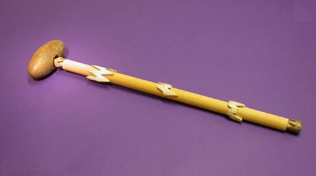
The mace head itself is highly unusual, as it is made of a piece of fossil stromatoporoid from Devon, given a beautiful oval shape, and drilled through the centre. The following comes from William Cunnington, one of the excavators of the Bush Barrow.

We next discovered, on the right side of the skeleton, a very curious perforated stone, some wrought articles of bone, many small rings of the same material, and another article of gold PLATE XXVII, No. 3, 4, 5. The stone is made out of a fossil mass of tubularia, and polished; rather of an egg form, or as a farmer who was present, observed, resembling the top of a large gimlet. It had a wooden handle, which was fixed into the perforation in the centre, and encircled by a neat ornament of brass, part of which still adheres to the stone. As this stone bears no marks of wear or attrition, I can hardly consider it to have been used as a domestic implement, and from the circumstance of its being composed of a mass of sea worms, or little serpents, I think we may not be too fanciful in considering it an article of consequence. We know, by history, that much importance was attached by the ancients to the serpent, and I have before had occasion to mention the veneration with which the glain nadroeth was esteemed by the Britons; and my classical readers will recollect the fanciful story related by Pliny on this subject, who says, that the Druid’s egg was formed by the scum of a vast multitude of serpents twisted and conjured  up together. This stone, therefore, which contains a mass of serpularia, or little serpents, might have been held in veneration by the Britons, and considered of sufficient importance to merit a place among the many rich and valuable relicks deposited in this tumulus with the body of the deceased”  William Cunnington, Manuscript Letters, Vol. 10, p. 9-13

“Stromatoporoidea is a class of aquatic invertebrates common in the fossil record from the Ordovician through the Cretaceous. They were especially abundant in the Sularian and Devonian. These invertebrates were important reef-formers throughout the Paeozoic and late Mesozoic. This group was previously thought to be related to corals and placed in Phylum Cnidaria. They are now classified as sponges (Phylum Porifera), specifically the scelosponges.  There are numerous fossil forms with spherical branching or encrusting skeletons of laminated calcite with vertical pillars between the lamina.” (2)

Pliny’s description isn’t too bad considering the mace had been in a grave for two thousand years by his time. Although William Cunnington connects this to the Glain Nadroeth, or Druid’s Egg, he doesn’t seem to have realized that this object is in fact the Glain Nadroeth of folklore. An artefact which has not been recognized for what it is. Our Wessex lord was the Arch Druid.

Celts are not thought of as coming to England until the Iron Age, supposedly from the Continent, having spread out from the La Tène and Hallstatt areas, but there is no proof of DNA or otherwise to show a mass migration into England and Ireland coming from those areas or from Europe at all at that time, mainly because the Celts were already in the UK and Ireland long before that. Both Bryan Sykes and Stephen Oppenheimer feel that both the hunter gatherers and the Windmill Hill people constitute the earliest Celts in the UK and Ireland. They may have brought the first Celtic languages with them. There are elements in the Welsh language which relate to Berber, Egyptian and Sumerian.  With Celts, came Druids, their priestly class, and Julius Caesar did say they started in England, and then went to Gaul. Since he wasn’t maligning them by saying this, this is likely a true fact. However, this priestly class likely existed long before that. Each group that entered the Isles probably had its own priestly class. Did they pool their belief systems and create a whole new religion, which they took back to the Continent where it spread over a huge area?

One of the other things found with the Wessex lord was at one time considered to be rivets from a shield and then a dagger, but Professor John North comments, “Fragments of wood that the excavators had thought were the remains of a shield were now described as the remains of an alidade (sighting rule) and a wooden drawing board or plane table”(see Stonehenge, Neolithic Man and the Cosmos, page 508) (3)

“An alidade (archaic forms include alhidade, alhidad, alidad) or turning board is a device that allows one to sight a distant object and use the line of sight to perform a task. This task can be, for example, to draw a line on a plane table in the direction of the object or to measure an angle of an object from some reference point. Angles measured can be horizontal, vertical or in any chosen plane. The alidade’s primary use is for creating maps in the horizontal plane.” (4)

It would seem our Wessex lord was the Arch Druid and an astronomer/surveyor. His large gold lozenge may not have been a breast plaque, rather it may have adorned his turban as seen in the Book of Kells. A forerunner of the diadem in Mycenae and the Gold Hats in Ireland, Spain, France and Germany.  My mother would say, the first man had a small lozenge on his head, the next one wanted something bigger, and the next one…………………..until we come up with the 90 cm. cone-shaped hat from Ezelsdorf, near Nuremberg a thousand years or so later. One of these gold hats was also found to be a calendar device, and it is possible that all of them may have had this function.

This is a most interesting picture, the Druid’s beard has been divided and turned into knotwork, using the same design as can be found on the Wessex lord’s large gold lozenge. I think in this case he is meant to be Manannan, he has the red M on his forehead. In fact, as you turn the page around, this becomes MEW3, which is shorthand for the four directions, and the four major divisions of the year. The monk who created this page understood Ogham, and has used it in the same way as the creator of the Sator Square. There are interesting pages in the Book of Kells which I will write about in the future. However, getting back to the gent with the lozenge on his head, I think he is carved at Newgrange also.


I think this particular stone must have stood upright at one time. The triple spiral now becomes a smiling face. He has rather fancy headgear with a lozenge on it. Newgrange dates c3150 BCE, about the same time that the first part of Stonehenge was created. The Aubrey hole circle was in existence before 3154 BCE, I figured their first calendar keeping day there was June 21, 3154. (5) Newgrange has another triple spiral just like this one inside. The Sunrise at Winter Solstice lights up this interior carving. If this is another astronomer/surveyor, what is he doing at Newgrange? Perhaps Newgrange was used for astronomy before people were buried there, or perhaps still used for that after they were buried there. Perhaps it was originally built for sky watching. The stars move by approximately one degree each night. If you sat inside Newgrange every night, you would be able to create a star map of that narrow band which would be visible. An observatory with a telescope, one which was stationary, unlike modern ones. If that seems like an odd idea, there have been passage ‘graves’ found which never had any burials in them, which puzzles archaeologists no end. One in France has the passageway on a slope, so you would be looking up at the sky at an angle which would be quite different from Newgrange.

If I seem to be hooked on astronomer/surveyors and calendars in ancient times, it’s because that is what I have been finding. Once I started to keep those things in mind, ancient artefacts and constructions took on a whole new meaning. Try it, you may be surprised by what you find. Just keep in mind that there were some very well educated people around at that time. People who were well versed in higher mathematics, astronomy, surveying, and navigation.

References

Ancient Celtic New Zealand

Ancient-wisdom.co.uk

Bryan Sykes, Blood of the Isles

Bryan Sykes, The Seven Daughters of Eve

Manuscript notes of William Cunnington

Stephen Oppenheimer, The Origin of the British

The British Museum

(1) Following the White Trail to Stonehenge Part I

(2) Stromatoporoidae, Wikipedia

(3) Ancient Celtic New Zealand, Martin Doutré

(4) Alidade, Wikipedia

(5) Following the White Trail to Stonehenge Part II

My upstairs files (my brain) which contain many snippets of historical knowledge which have no foot notes.

Pictures

Maps from Wikipedia under Doggerland, The Beaker People, Megalithic Culture

Wrist guards, Wiltshire Heritage Museum

Vinca Script, kachina2012.wordpress.com

Rillaton Cup, British Museum

Ringlemere Cup, computer reconstruction, British Museum

Mycenaean Treasure, photo by Ruth van Meirlo at Wikipedia, Mycenae

Cross section of Maes Howe, the Treasury of Atreus and the entrance of Newgrange, Wikipedia

Amber necklace from Upton Lovell G2e, Wiltshire Heritage Museum

Gold covered shale button and large gold lozenge, Wiltshire Heritage Museum

Sun and Moon Lozenge Applet, J. Giesen

Gold Lunula, British Museum

Lunula calendar, Celtic Sprite, article by Eliseo Mauas Pinto

Two gold lozenges and belt hook, Wiltshire Heritage Museum

Head of the bronze dagger, Wiltshire Heritage Museum, drawing by Philip Crocker

Gold dagger from Ur, Penn State University

Cone Mosaics from Uruk, Pergamon Museum

Bush Barrow Mace and mace head, Wiltshire Heritage Museum

The bronze alidade and rivets, Wiltshire Heritage Museum

The Chi Rho or XPI page, The Book of Kells, Wikipedia