The Amazing Book of Kells

The Book of Kells is considered the pinnacle of Insular illumination. Insular art, referring to the fact that the type of artwork found within the Book of Kells, the Lindisfarne Gospels, and other such manuscripts, was only found in the UK and Ireland. Perhaps it should be Insular Celtic art, that is at the root of the decorations. These include spirals, triskels, and the most complicated interlacing made up of vegetal, animal and human elements. The Book of Kells has the most ornate decoration which can be found in manuscripts dating c600-900 CE.  There is still a great deal of debate about its creators, and the place it was created at. It is called the Book of Kells because it resided at the Abbey of Kells in Ireland for many centuries. However, the tradition which names Iona as its place of origin may be correct, since the Chi Rho or XPI page does tie it to the one from Lindisfarne, and the Cygnus formation Derek Cunningham found on the landscape of Scotland. This star map includes Iona, Dunkeld and Holy Island, which is also known as Lindisfarne. St. Columba started his career at Kells, was sent to Iona to found a church there, and was also said to have built a church at Dunkeld. Iona was the mother house of Lindisfarne.

There are traditions which credit St. Columba with some of the artwork, but the experts think it dates c800 CE, later than St. Columba, who died in 597 CE. Their opinion is based on palaeographic and stylistic grounds. Since I’m not an expert, I won’t argue with that, but the Book of Kells includes much older, Celtic pagan symbolism, and at least one person creating the artwork understood Ogham.  I discovered the pagan symbolism after studying many examples of Celtic art, which very often include double heads. Sometimes it is presented as one head, but if you turn it upside down, it looks like a different head. Sometimes it is two heads or two men, symbolic of the Summer lord and the Winter lord.  There are also examples of a man’s head becoming a woman’s head when turned upside down. This is usually the goddess and her consort. I wondered if this had continued on in the monasteries, and found it did in the Book of Kells, at least on some pages.

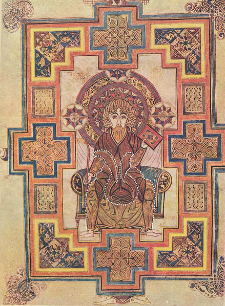
Since I’ve only just written about the propheta head-gear, I thought I’d write about the portrait of St. John first. This page has always been a bit of a mystery, since St. John seems to have hands for feet. The monk did know how to draw feet, there’s a pair of them below the frame of the picture. Incredibly, some of the artwork in this book was considered rather childish at one time. I have not read any of the latest books devoted to the Book of Kells, so I don’t know if someone else may have recognized some of the things which I have found there. However, in “The Book of Kells”,  as described by Sir Edward Sullivan, which also includes a historical analysis of Celtic illuminated manuscripts by Johan Adolf Bruun, there is no mention of the things I have discovered. Only the obvious is mentioned, but the things I find just as obvious are not mentioned. Perhaps the critics of the early 1900s didn’t recognize the old Celtic pagan and astronomical messaging.

Once I had recognized the propheta head-gear, I realized that it is a person kneeling in front of St. John, that’s why he has his hands on the floor. St. John wrote Revelations and became a prophet by doing so.  The way it has been designed, makes it look as if it is part of St. John, but may hold more meaning. If this propheta head-gear was part of the druid tradition, then it is showing the old propheta kneeling and bowing his head to the younger one. Christianity taking over from the old ways. This monk created some of the most outstanding pages in the book, that I have seen. Even if it was c800 CE, this monk was still hanging on to the old ways, and like a true Celtic artist, he left messaging in his work. The sort of messaging which many people have totally missed, because much of the symbolism is very old. The Hittite hieroglyph for ‘propheta’ dates between at least 1700-1200 BCE. Even if it was 1200 BCE, it would still be a 2000 year old symbol this monk was using.

The clue to this page is on the book St. John is holding. There we have a lozenge or diamond divided in four. The lozenge or diamond, and the number four both symbolize the ‘hidden secret’. No lozenge or triangular shape in or on ancient artefacts in the UK and Ireland should be disregarded. They all belong to the knowledge of the astronomer, surveyor, navigators. It’s a signature they left behind. The first thing I noticed on this page was the haloed head, then the beard and down the arm, which is positioned in the wrong place. No doubt on purpose. This is the one holding the book, which told me there was a hidden secret on this page. The secret being the kneeling prophet.

I think two different people worked on this page. The original monk created the layout, the central figure, the four corner decorations, and the decorations around the frame.  He has the two faces on the outside of the four corners. These look more animal than human, but they are still the Summer lord and Winter lord. The four equal armed crosses and the rectangles on the border were filled in by someone else.  Someone not quite as talented as the original artist.

The corner detail is quite wonderful, its been bordered in yellow with a step formation suggestive of lightning. Inside of this is the Square of Enlightenment, the square with its corners turned to the cardinal points, which contains two white dogs entwined with eight horned serpents. Likely the dogs’ ears were red. Many Sun gods were accompanied by white hounds with red ears. The dogs in this picture are the two halves of the year. The eight serpents represent the eight divisions of the year. Their bodies form twelve triangles, the twelve months of the year.

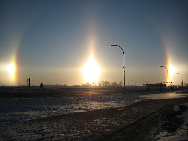
There are a great many stories about the white hounds with red ears, which made me wonder what that was all about. Looking at it astronomically, I discovered that these likely started out being Sundogs or parhelia. Parhelia comes from the Greek word, parelion, meaning ‘beside the Sun’. These are an atmospheric phenomenon that creates bright spots of light, often seen on a halo as shown below. They are often coloured, with red closest to the halo, and white and then blue further out. They appear to the left and right of the Sun, 22° distant and at the same level as the Sun.

Sundogs can appear anywhere on Earth at any time, but are best seen at dawn or Sun down, and since atmospheric ice crystals create this interesting effect, they are seen more often at cold times of the year. There are also Moon dogs which people seldom see, since it’s at night. Like eclipses, they were feared in ancient, and not so ancient times. They were generally viewed as bad omens. Hence the stories of Hell hounds, which were white with red ears. Since it appears like three Suns, I have to wonder if this is why Lugh/Lugus was sometimes shown with three faces or heads. The Sun in the centre is referred to as the ‘pillar’. Oddly enough it has a triangular head, similar to the Lugh’s head I hung at Stonehenge.

References

The Book of Kells, described by Sir Edward Sullivan, with commentary by Johan Adolf Bruun

The Book of Kells, Wikipedia

The Book of Kells, about.com, Medieval History

The Weather Doctor, Sundogs

Wikipedia, Sundog.

Picture of Sundogs at Fargo, North Dakota, taken on 18 February, 2009 by Gopherboy6956, found at Wikipedia.

Portrait of St. John from the Book of Kells found at about.com, Medieval History

Cygnus, Thoth, XPI, and the Brodgar Complex

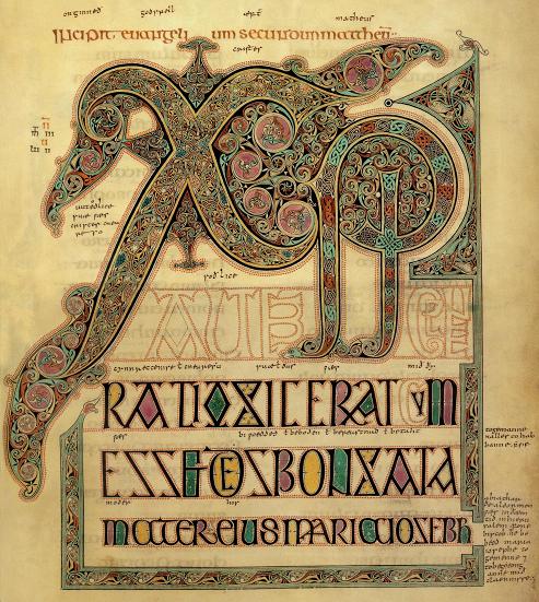
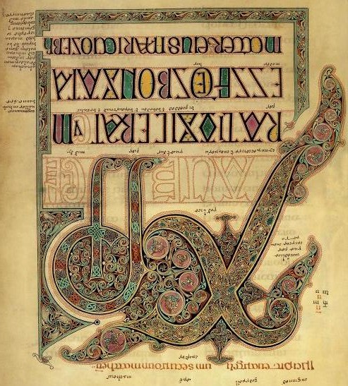
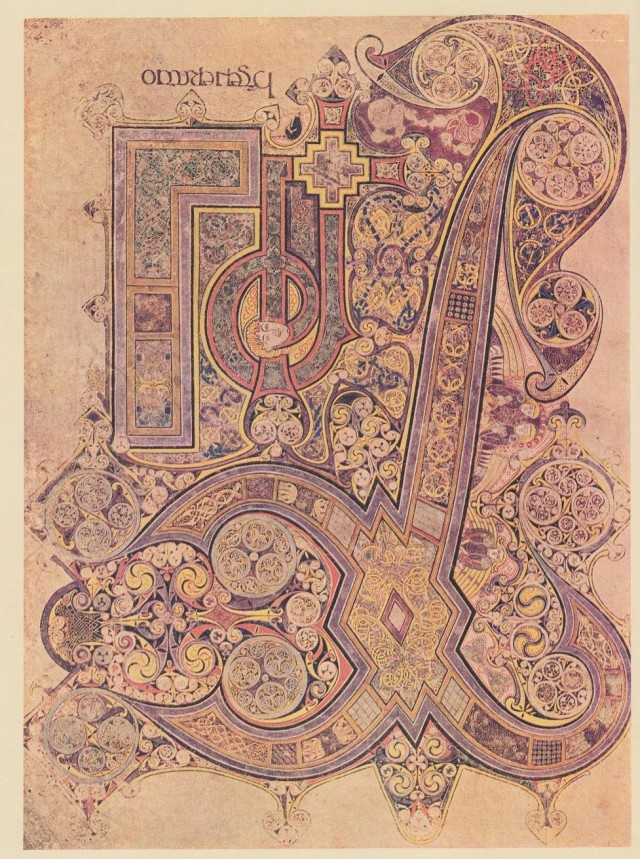
The story about the two XPI pages from the Book of Kells and the Lindisfarne Gospels, has become somewhat more complicated, but much more enlightening, since it explains why these two pages used the same theme. At these two places. The Book of Kells was made on the Island of Iona, which is on the west side of northern Scotland. The Lindisfarne Gospels were made at Holy Island, off the north east coast of England. Iona was the mother house to Lindisfarne.
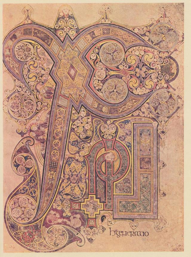
The big X on both pages, which is a bird, the Swan, is laying an egg with his wing tip upon something with the head of an Ibis. There’s the head of a man, who seems to be wearing some sort of turban. They both have the straight staff and the one with the curl in it, which are the bird’s legs. They both have many other things made up of triskels, which make up little pictures, and both have birds entwined. The Book of Kells also has serpents  and ‘beard pullers’ entwined. These two pages belong to the story, ” Thoth, as the Ibis, laid an egg on the Mound of Creation, which is Hathor as the Milky Way. From the egg, Ra, the Sun god was born”. Even though both these pages say XPI for Christos, which is the Greek version of the name. The early Christian manuscripts were written in Greek, Latin didn’t come to the UK and Ireland for a few centuries after Christianity arrived.  Both books do use Latin in the script, but in special cases, Greek still shows up, particularly in the Book of Kells. As in the word Christos, since the monk who created the page in the Book of Kells, actually spelled out the word on the page. He also used Ogham to give symbolic messaging, craftily hidden in plain sight. That is, if you can recognize it.
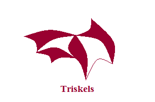
Triskels are basically shapes with three corners, which according to the experts represent the Trinity, but they came into existence long before Christianity, so a different sort of Trinity at one time. Past, Present and Future, the three Planes of Existence. The picture below  shows the sorts of shapes they could become, but the sky’s the limit when it comes to the different shapes, as long as they had three corners. Beard pullers are men with one lock of hair and their beards knotted up with each other or some other object.
Sometimes when I want to write about a topic, I seem to hold back. It’s not prevarication, rather it feels like waiting. Waiting for what? Waiting, because I feel that there is something missing about that particular topic. Something which will be important, something which might explain the subject. I take notice of this feeling, because I have found other things when this has happened before. I generally search the web for artefacts and articles, or I read some of my books, not really knowing what I’m looking for, but knowing I’ll find what ever it is I’m supposed to find. Quite often, the find is a coincidence, like someone posting an address on another blog, which just happens to give me one of my answers. This did in fact happen this time, but along with that, I also found something else. The two together are quite interesting.

The first thing I came across, were some papers written by Derek Cunningham, in which he theorizes that there was once a world map created, which was based on Cygnus. He actually started out trying to disprove the theories of Andrew Collins in the Cygnus Mystery. Andrew Collins and Rodney Hales showed how the layout for the Great pyramid and its companions match the formation of Cygnus better than Orion, which is logical, since Thoth was supposed to have been the architect of the Great pyramid. Thoth being Cygnus, usually shown as the Ibis. Instead, Derek Cunningham found that this theory is correct, and that it connects to a whole world map based on Cygnus, the Swan or Northern Cross, which seems to have been used by ancient mariners. Just can’t get away from those astronomer/navigators. His theories, maps, and pictures do suggest that he is correct about the world map.

His map of Cygnus on the landscape of Scotland was based on geoglyphs that he found. They include large Xs, parallel lines, a triangle with lines leading in all directions coming off it, and some strangely shaped lakes. He also took into account the ancient Christian places of Iona, Dunkeld and Holy Island because they were supposed to have been built on land which was sacred long before Christianity came along.  Close to Dunkeld there is a nest of lines, parallel, triangular, etc. The map below is part of the result. This is a mirror image of what appeared in the sky when  this mapping system began, which Derek Cunningham dates to between 10,000-12,000 BCE. So right after the Big Ice had mostly melted away. As can be seen, these lines run to other important places in the world, and one from Calbost runs all the way to Giza in Egypt and beyond. It could take you to Australia, particularly if there was a canal in ancient times where the Suez canal is now. I have read about such a canal more than once in my lifetime. The line running to Jerusalem is likely Mount Carmel which figures in the St. Michael-Apollo Line.
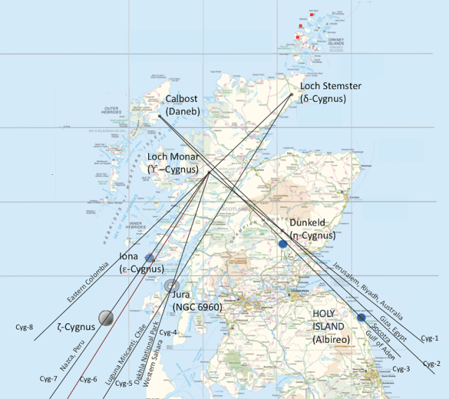
However, Scotland didn’t look quite like this at the time, since this is before the Storrega Slide, and the incredibly bad tsunami it created, wiping out a great deal of Doggerland, and parts of Scotland. The Hebrides and the Orkneys were then part of a solid piece of land as shown below. These Islands must have been high points of land for them to have survived the flooding.  This is likely why so many islands, all the way back to Cyprus, were considered holy islands. They survived all the flooding which took place after the Ice Age ended. This is probably why so many ancient constructions were placed on high ground, they might survive if there was ever anymore flooding. This likely accounts for megalithic building, even though most of it happened much later.

The three red dots on Derek’s map, are ones I added. These are three wing stars which are part of Cygnus, which he didn’t take into account, but I did, knowing what is up there. Many Christian, Roman and Norman sites were built over much older sites, which were part of the original geodesy. It is possible that the very early Church had people who still understood this. At least it would seem so with the two XPI pages.
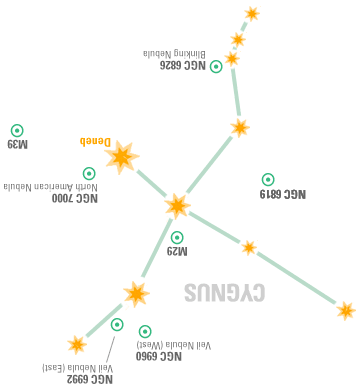
These three dots are very important to this story. I first put in the dots, and then went to look at a close up map of the locations. One is on Mainland Orkney, where there are two major roads which cross in a  big X formation. One dot falls on water, possibly land when this was created. The third dot is on Papa Westray, where an ancient tomb named the Holm of Papa Westray, and the Knap of Howar can be found. Up until a few years ago, the Knap of Howar was the oldest farm in Europe, it dates c3700 BCE. Since then, another farm has been discovered on the east side of Scotland, which has been dated c4000 BCE. The people there kept cattle, sheep and pigs, and grew several types of grain crops. The island of Wyre has also produced a settlement which so far dates c3300 BCE. Jura had people settled there in the Mesolithic. Scotland is becoming a regular hotbed of ancient constructions, and archaeologists are now realizing that the Orkneys do seem to have been the centre of some very important goings on. There’s the Barnhouse settlement close to the Stones of Stennes, and possibly two close to the Ring of Brodgar. One settlement has been found north of Brodgar by magnetometry scans, a whole new settlement which was unknown up until now.

It is the view of the archaeologists that the whole peninsula of Brodgar could well hold a great deal more. A circular enclosure has been spotted from the air close to Maeshowe, although it isn’t known at present what this might be. What has been uncovered so far at Brodgar, suggests that there were alignments to the Equinoxes and the Solstices, so all Solar.

These buildings at Ness Brodgar are quite substantial, particularly Structure Ten. It measures 25 metres (82 feet) long and 20 metres (65 feet) wide in outside dimensions. The walls are five metres thick. It has a paved walkway all around, which may also have been covered by the roof.  Inside have been found a central hearth and four ‘dressers’, although these are now being viewed as ‘altars’. These were free-standing rather than placed against the wall as at Skara Brae. Far enough away from the wall so that you could walk around it.  They were made of yellow and red sandstone, their origin is not known at the moment, but this sandstone was brought from elsewhere.
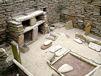
                                                                            A  typical ‘dresser’ at Skara Brae

Structure Ten at Brodgar has now been jokingly called the ‘Cathedral’. Structure Eight at the Barnhouse settlement, close to the Stones of Stennes, shows evidence of having had a slate roof, many slates were found inside, all nicely even in thickness and cut squarely. Some have also been found in structure Ten. Neither hearth in Ten or Eight seems to have been used for cooking, all cooking at Eight seems to have taken place in an adjacent paved area outside. At Skara Brae, all the cooking seems to have been done in a building separate from the rest. Very monastic-like.

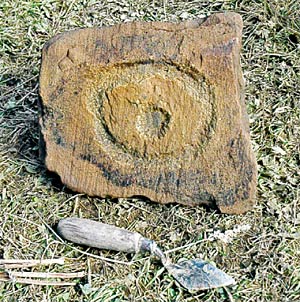
The outside stonework of Structure Ten was very well made and quite beautiful, but the inside stonework was rather “scrappy”, says Nick Card, archaeologist at the site, as if the building was meant to impress from the outside, but few people may have actually used the inside. The building is aligned east/west, with an entrance in the east, an Equinox alignment. Near the altar/dresser, which faces the east entrance, was found a stone now known as the Brodgar Eye. It is thought to have been part of this altar/dresser, and that the Equinox Sunrise would have shone right on it. Nick Card wondered if this was a Sun symbol. Yes indeed, it is a very ancient Sun symbol, and in Egypt it was a symbol for light. The monk who created the XPI page from Lindisfarne, used it on that page. The Druid’s beard is flowing toward it.
My own thought about this building, is that this was the headquarters and workplace of the astronomer/navigators. The altar/dressers were desks, a work surface to create maps on, likely made on hides. The tops themselves may have star maps on them, since they have pecking and cup marks and ‘decoration’ on them. The shelves below were for these rolled up hide maps, their ink cakes and pens made of reeds or quills. Swan’s quills? The Equinox Sunrise alignment makes perfect sense, the best long distance sailing time occurs between the Spring and Fall Equinox, particularly in a time with no motors, radio, radar, GPS, and all the other modern gear we have today. Even with all that, the Atlantic is no picnic in December.

It is starting to look as if all the Orkney Islands were inhabited in the Neolithic and Bronze Age, and that they were inhabited for at least a thousand years.  But the excavations are nowhere near finished, and the archaeologists think that there could still be whole layers of other constructions further down at Brodgar, which could show that it was inhabited for a much longer time. At the Links of Notland, on Westray, another settlement is being excavated. This is where the Orkney Venus was found. It has the same eyebrow/eye motif which was found at the Holm of Papa Westray, a chambered cairn.

These carvings are reminiscent of the Folkton Drums which also have the eyebrow/eye motif on them.  The motif on the Folkton Drums is part of the Akhet, the Sun between two mountains. The Winter Solstice Sunset, as seen from Maeshowe and other places belonging to the Brodgar Complex, happens between two mountains, where it sets into the Island of Hoy. There are special sightings of Venus about those same mountains. The eyebrows on the Folkton Drums is a large winged bird, Cygnus. Another carving has been found on Westray, part of the wall of what is considered an important building, also with fine stonework and larger than the rest so far excavated. Here we have the Akhet again, and that story, “Thoth, as the Ibis, laid an egg on the Mound of Creation, which was Hathor as the Milky Way. From the egg, Ra, the Sun god was born”.

That big winged bird was of prime importance to the world map, which Derek Cunningham discovered. He drew lines running from the various sites in Scotland on a world map in the following picture. Notice how there are three lines running from Scotland through the area of the Suez Canal? They could take you right to Australia, if there had been a canal there in ancient times.
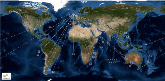
Certainly looks as if Scotland was the place for ancient astronomer/navigators. And what do the two XPI pages have to do with this? Turn the pages upside down, and now consider the Cygnus over Scotland map, and the Mound of Creation with its Ibis head, now becomes the Orkney Islands. Holy Island is Albireo, the head of the Cygnus Constellation. The Druid’s head on the Lindisfarne page has his beard flowing toward the south west, the direction of Sunset of the Winter Solstice. The head on the Kells page is facing west, the direction of Sunset on the Equinoxes. Seems those monks who made these pages, must have been aware of this lovely piece of geodesy, and they left us a record of those times, which occurred thousands of years before they were born. St. Columba, of Druid heritage, was at Iona, and seems to have built a very early church at Dunkeld. The later medieval Cathedral there was dedicated to St. Columba. With his background, he may have known about this geodesy. Iona was a Druid mystics’ retreat long before Christianity.
Were the people at Brodgar Druids? At the moment it isn’t known, but it is believed that there was an elite priesthood there. One which was certainly concerned with astronomy. Much artwork has been found there, although I have only seen the Brodgar Eye. One building had a stone with eight rows of lozenges, another had a cist in the floor covered by a triangular stone. It was situated in such a way, that you would have to walk over it. There are also other markings there, which by the description could be Ogham. Perhaps I can get some pictures, that is if I can get any answers from the archaeologists. One can only hope at the moment, but the Brodgar Eye and the Akhet, do point to Egyptian connections, even the monks made the head of the Mound of Creation, the head of an Ibis. As far as I know, there is only one connection to an Ibis, and that’s Thoth in Egypt.
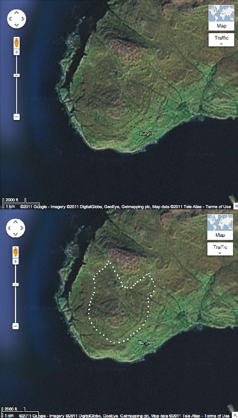
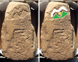
Derek Cunningham made many interesting discoveries, but one in particular caught my eye. A spiral hill on Iona, I outlined what I could see there. Hmmm………The Horned Man? Or does this actually mean something else?

Among the contents of a Hittite sign list, I found a symbol for, propheta. This word is in Luwian, a language connected to Wilusa, which is where the city of Troy was. Propheta is self-explanatory, prophet, in other words. But a prophet in ancient times, probably started out as an astronomer/astrologer. They made prophesies using the Sun, Moon, planets, constellations and other stars. What he has on his head is a sort of turban with long tails, which explains the head-gear being worn by the men on the two XPI pages, and likely this head on the landscape of Iona. As I said, Iona was a Druid mystics’ retreat long ago. Mystics are often prophets. If this head is as old as many of the other geoglyphs, then the people at Brodgar likely were Druids. They were at Silbury Hill c2500 BCE.

References

Midnight Science Journal, papers by Derek Cunningham

Orkneyjar, postings by Sigurd Towrie

Dunkeld, Wikipedia

Pictures

XPI pages from the Book of Kells, the Lindisfarne Gospels and the Doggerland map, Wikipedia.

Map of Cygnus over Scotland, World line map, and the spiral hill on Iona, Midnight Science Journal, papers by Derek Cunningham. Cygnus over Scotland on an Ordinance survey map. World map from Mapquest. Iona spiral hill from Google-Imagery

Propheta from Hittite Sign List pdf. author Gunter Anders

Cygnus map, starrynighteducation.com, Oaklands Astronomy Club

Orkney Venus, carvings at Holm of Papa Westray, the Brodgar Eye, picture of excavation at Brodgar, picture of the Akhet stone, the stone dresser at Skara Brae, and the magnetometry scan from Orkneyjar, posted by Sigurd Towrie

Folkton Drums, Ancient Celtic New Zealand.

Contemplating the Ancient Mind


There is a great deal written about what ancient people thought about life, death, religion, and how they viewed the world around them.  These are all personal views, which quite often have little basis in fact. One archaeologist thinks that Stonehenge was a Temple of Death, while another thinks it was a Neolithic Lourdes. One basis his belief on the fact that there are many people buried within and around Stonehenge, but then again, his specialty is in ancient death practices. The other, basis his belief on the fact that many people seem to have died of some trauma. Many head wounds were found, and such people as the Amesbury Archer with his missing knee cap and his abscessed jaw. He believes that people were brought there to be healed. He may not be far off. The 19 Bluestones in the Horseshoe gave Eadha or White Poplar in the Ogham tract. It is connected to healing and rebirth, and when the wind blows, the leaves rustle, giving that small still voice of God. Important medicines were made from it.

They may both be right, or not. There are hundreds of theories about Stonehenge, ranging from, it was an alien’s landing pad, to, it was a place for human sacrifice. The truth is, no one really knows what it was for, although the people there do seem to have taken an uncommon amount of notice of the objects in the sky, and the calendar. Obviously this was very important to them, and they left their monuments, stone markers, tumuli, tumps, mounds, long barrows, and other such constructions all over the landscape in the UK and Ireland. Each one of these things seems to have been placed at that very spot on purpose, creating interesting geodesy. As an example, Callanish is 5° north and 5° west of Arbor Low, which is  2° north of Stonehenge. The Callanish stone circle and its outliers look like a big winged, long legged bird. Arbor Low’s recumbent stone ‘circle’ is white quartz and egg shaped. Stonehenge is 1° east of Glastonbury Tor. Creswell Crags, and its interesting bird carvings, is 9° west of Heligoland. These are only a very tiny bit of what exists on the landscape, there are hundreds of other examples. Sure looks as if someone was mapping the place methodically.

In later times, many of these sites were built over with churches, chapels, shrines, castles, and Templar buildings. They erased, or tried to erase, the ancient constructions, but kept the geodesy alive, and the Knights Templar were likely the only ones who knew and understood the geodesy. This didn’t just happen in the UK and Ireland, it was also created all over Europe, and all the way back to the Middle East. Actually, this can be found all over the world, and all these places appear to connect together, belonging to one world mapping system. There was a group of people who wanted a world map. The only people I can think of, who would need such a thing are, navigators, traders, merchants, and explorers, looking for minerals and anything else of worth. No doubt sent out by rulers of established societies. It has often been said that farmers did not need a calendar to plant or harvest by, which is quite true, the weather conditions and the ripeness of the crop tells me that. But if you were a navigator in ancient times, it would be very important to know which month it was. Just because it may be sunny and warm on land in March, the oceans are not that accommodating in March.

However, I thought I would have a look at some things which appeared somewhat simpler, to see could I catch a glimpse of that ancient mind. The first is a necklace from the West Kennet Long Barrow, possibly 2500 BCE, and the other is the original core or mound of Silbury Hill.

This necklace is incredibly primitive looking, what with the stones and the bone. The objects are: a piece of bone, a tooth, a piece of tusk, a shell, and three pieces of shale. One piece of shale is very dark, and looks as if it has been polished. The shale wheel, at the front, has been made so that the line between two layers of shale falls in the centre of the wheel. It may also have some decoration on the side. It can be seen that the craftsperson put a lot of work into making nice round shapes. I couldn’t imagine why someone would put such a thing together, and yet it must have had an important meaning, since it was buried with someone in the West Kennet Long Barrow. The piece of bone kept tugging at my brain, until I realized that all these things have the same function. Stone is the bones of the Earth, creating its contours. All animals have bones which gives them their structure and shape. Snails have no internal skeleton, their shell is their exterior one. A tooth and a tusk are extensions of bone. Even after everything else has decayed, the skeleton with its teeth and tusks remain, and would have been seen as belonging with all these ‘bones’. All bones of different varieties.
So, primitive looking, but well thought out, and many hours spent creating the different pieces. The four light pieces may have represented the four Albans, which are the two Solstices and the two Equinoxes. The dark pieces, plus the person wearing it, would then represent the four Fire Festivals, February 2, May 1, August 1, and October 31. The deceased would then represent that dead period between October 31 and December 21. October 31  was the time of the year when the veil between this world and the Otherworld was believed to be the thinnest, and that one could communicate with one’s dead ancestors at that time. The tooth is December 21, the Coming of the Light, and Cernunnos, when much pork seems to have been consumed at Durrington Walls. The polished shale is February 2, the Feast of Brigid, the bone is the Spring Equinox, the central wheel is May 1, which festival was celebrated by bonding of male and female. The tusk is June 21, the shale wheel, August 1, and the shell is the Fall Equinox, and so back to October 31. A fitting necklace for someone going to their grave. Quite possibly made just for this purpose, not something worn in life, only in death.

Silbury Hill also has such a puzzle at its original core, which was a simple mound. One statement I read said that nothing of significance was ever found at the core of Silbury Hill, only sarsen, flint, clay, topsoil, moss, turf, fresh water shells, ox bones, antler tines, Oak, Hazel and Mistletoe. Those last three made me perk up, seems there may have been something very significant there. These various items can be put into groups. Sarsen and flint, clay and topsoil, gravel and shells, moss and turf, ox bones and antler tines, Oak, Hazel and Mistletoe. Since Mistletoe is a parasite which lives on other trees, this can be seen as six groups of two, even though there are thirteen separate types of objects. They represent 12 Solar months and 13 Lunar months, which take almost the same length of time. Mistletoe was gathered with golden sickles at the full Moon closest to the Winter Solstice.

Stone is the bones of the Earth, covered by clay and topsoil, which is covered by moss and turf. Oak and Hazel grow above the moss and turf. Mistletoe grows on Oak. Gravel belongs with water. Wherever you find gravel, water once flowed there. The shells also belonged to the water element. The two land animals, cattle and deer, represented the Summer Lord and Winter Lord, but also two prime sources of meat, hides and all the other parts which were used for various things. The stones found were sarsen and flint. Sarsen was used to build all the megalithic constructions in the area. Flint was used to make all common tools which were essential for day-to-day living. Clay was used to make pottery, and food such as a bird or fish were often wrapped in plantain or some other leaves, and then covered in clay. It could be placed close to the fire or in a ground pit for slow cooking. A slab of clay was placed in boats, and used as a hearth for cooking on. It was also used to make clay tablets to write on. Topsoil is what you grow your crops in. Moss had many uses for personal hygiene, for insulation in shoes and boots, caulking in houses and boats, and had medicinal uses. Turf is where you find edible plants, roots, herbs, mushrooms, berries, medicinal plants, items to create dye, and grasses to weave into mats, bags and other containers. Turf was used to roof some buildings, even turf huts were created. Cattle and deer, live on the turf, not only to wander around on and sleep on, but to eat also.

The Oak, Hazel and Mistletoe are a dead give away as far as Druids are concerned. These three are among the most sacred in the Ogham tract, where each is given a chieftain designation. Oak represents solid foundation, solid protection, the Doorway to Enlightenment/the Mysteries. It represents the Druids themselves, they were the Doorway to Enlightenment/ the Mysteries, they were the teachers. The Hazel brings to mind the Hazels of Wisdom, which is just shorthand for all the knowledge the Druids had. Mistletoe was called All Heal and is used in cancer drugs today. At that time it was considered a fertility symbol, and was seen as a spiritual connection to the land. On the bottom of a Mistletoe berry, can be found four semicircles around a central dot. These represent the four cities of the gods, Filias, Finias, Gorias, and Murias. These represent the four cardinal directions, and the four ancient elements. Earth in the North, Air in the East, Water in the West, and Fire in the South. The central dot is the etheric centre which joins together the three planes of existence, past, present and future. This is the basic symbol for the Celtic equal armed cross, which can also be shown as the upright pentagram. The point at the top symbolizes the supremacy of the spiritual and divine over the world of matter, shown by the other four points. The most sacred Mistletoe grows on Oak, which doesn’t happen very often. Because Oak is so long lived, it is a powerful fertility symbol. Mistletoe on Oak would have been considered the most potent.

So what was Silbury Hill? No burials or treasure have been found to date. It started out as a tump, which looks much like a round barrow, although they can vary in size. Most tumps were way markers, and Silbury Hill is on the St. Michael’s Ley. There seems to have been some time between the building of this mound, and it being enlarged to become the great hill that it is today. It started out as a sacred connection to the land, sacred not only because of its contents, but also because it belonged to the geodesic system which existed there. After it had been greatly enlarged, it was probably a beacon hill. Even during the day it was glaring white, at night there would have been a fire there, and it still would have shone by the light of the Moon and stars.  Ancient-wisdom has the following to say:

“Silbury Hill is just one in a line of natural and artificial mounds along the St. Michael’s ley, which itself has a strong association with astronomy. Perhaps it is a coincidence then that Silbury Hill and Stonehenge combine with Glastonbury, the ‘Sacred Heart of England’, to form a vast right-angled triangle across the landscape. At the same time as the hypotenuse of this triangle reaches from Avebury/Silbury to Glastonbury, the opposite side is also part of a large geometric alignment, being one of the edges of the great Decagon first observed by J. Michell, while the adjacent side continues north to Arbor Low, and south to Mont St. Michel in France.

The line of the Sun would be Sunrise around May 8th, the Feast of St. Michael.

The map below shows what would happen if the water in the Kennet River was five metres higher, which it may have been at the time. Even Glastonbury Tor was surrounded by marsh and water in ancient times.

Silbury Hill now makes perfect sense. If you were sailing up the river, you wouldn’t be able to see Avebury because Overton Hill and Woden Hill would obstruct your view. Silbury Hill shows you the correct channel to sail up to Avebury Ring, which may have had a canal around it. The ditch there would certainly be wide enough and deep enough to accommodate small and medium sized boats. So, Silbury Hill became a large beacon hill on the old road systems, whether you were traveling by land or by water. Considering how many things it is connected to, it would certainly have been a sacred connection to the land. A major geodesic marker. Going NE on the St. Michael’s ley would eventually take you to Yarmouth, Heligoland and other places in Scandinavia. Going SW on the St. Michael’s ley, it connected to the St. Michael-Apollo line at St. Michael’s Mount, which could take you NW to Skellig Michael in Ireland, or SE to Mont St. Michel in France, and all the way to Mount Carmel in the Holy Land. Quite a network. Strange that we still refer to such a thing as a ‘network’. That’s exactly what those ancient astronomer, surveyor, navigators created, a network, marked by mounds, standing stones, circles, long and round barrows, ponds, springs, and sometimes trees as guide posts.

There are interesting things which happen at Silbury Hill. I watched a video online which showed Sunrise on the Fall Equinox at Silbury Hill. The Sun looked as if it were rolling up the hillside, and when it reached the top, it went sailing off into the sky. Someone knew the angle of this Sunrise and built the hill to match. Around May day, if you stand on Woden Hill, looking right at the top of Silbury Hill, you will see the Sun set right into the horizon and Silbury Hill at the same time.  Someone knew how high to make the hill to obtain this effect. So…….what is up on Woden Hill?  I’ve never heard of any archaeological investigating going on there, but Woden Hill is the best command post in the area. From there, you could see Windmill Hill, Avebury Ring, the Sanctuary, Silbury Hill, the West Kennet long Barrow, and all the way to Stonehenge, as well as the river system. Some theories have it, that Silbury Hill had a spiral path going around it from top to bottom. This would make it look like a snail from the air. Snail in Welsh is, malwoden, which could mean Woden’s Mill, and like a snail it is hugging the river bank on the map.  How ironic that it should be so close to Woden Hill, or is it? Or is this just another example of those ancient surveyors and their sense of humour?

Hmmm………….seems those two things weren’t that simple after all, and Silbury Hill led me right back to those ancient map makers.

References

Ancient-wisdom.co.uk

The Celtic Tree Oracle by Liz and Colin Murray

Pictures

Visioning by Susan Seddon Boulet

Necklace from the Wiltshire Heritage Museum

Silbury Hill, right-angled triangle and map from Ancient-wisdom.co.uk

The Mold Gold Cape

The beautiful Mold Gold Cape is certainly worth having another look at. This wonderful article was found in 1833 by workmen quarrying for stone when they came upon a stone cist. They had been digging in a burial mound named Bryn yr Ellylon, the Ghost or Goblins’ Hill near Mold, Wales. The person in the cist was wearing the cape. Unfortunately the skeletal remains were fragmentary and the cape crushed and broken into several pieces. Many pieces were removed by various people, and it took many years to gather as much as possible.

At first it was thought to have been a corselet or breast plate which passed beneath the arms, but by 1904 the British Museum was presenting it as a chest ornament for a pony. By 1950, it was finally suggested that it could be a cape. Another fifty two years went by before all the pieces had been put together, which proved that it was a cape. A cape which would only have fitted a slight person, thought to have been a woman. No weapons, axe, mace, ‘wrist guards’ or other male accoutrements were found with this person.

                                                                             The Amazing Detail

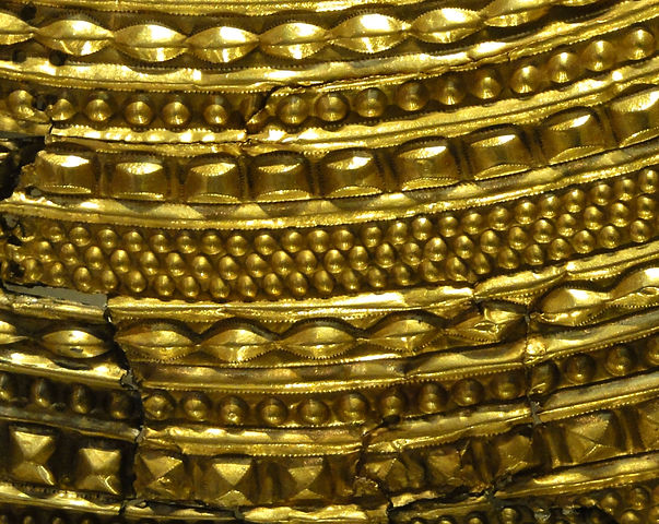
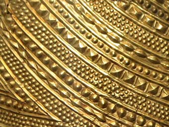
The cape was made out of a single ingot of gold, which was then decorated with rows and rows of different shapes. It looks rather like strands of beads between folds of cloth. The motifs have both Continental and indigenous roots. Some similar designs have been found in France, which are believed to have drawn on designs from central Europe. The lenticular bosses have been found on bronze spacer plates for a necklace  in Migdale, Scotland, and on a bronze armlet from Melfort, Scotland. This motif, surrounded by fine dots outlining the shape, seems to have been used in Scotland for some time, and appears to be part of the indigenous repertoire. This cape is unlike anything found from that time period, or any other period. The craftsman was an exceptional goldsmith, with an impressive artistic flair. It must have made a huge impression on all those who saw this object. At that time, 1900-1600 BCE, it is estimated that there may have only been fifty bronze daggers in all of the UK and Ireland. So most folks were still using stone tools, while this person was walking about with a gold cape.

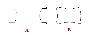
I think of these shapes as houses (large domes); seeds (small domes); lenticular shapes (beans); pyramid shapes ( temples?); rectangular shapes (metal ingots). However, the most standard shape of ingots in ancient times is shown in fig. A. A hieroglyph from Urartu, an Iron Age kingdom around Lake Van and Lake Urmia, looks more like fig. B. So perhaps these shapes are meant to be ingots of metal.

It is believed that this very wealthy person may have had connections to the Great Orme copper mine, which was the biggest copper mine in Europe at that time. Who and what was this person? Queen? Priestess? The Oracle? “Oracles are best in the defence”, says the side of the Queen Stone which points in the direction of  North Wales. The Neolithic house below, named Cul a Bhail, was found on Jura, an island off the west coast  of Scotland. It is very much like a tholos, although they were more dome shaped. But different materials sometimes make for a slightly different shape. The tholoi on Cyprus had stone foundations and mud brick domes, and in Mesopotamia they were made from mud brick. The mud brick was plastered over with adobe, while this house was made of stone, wood and thatch but the basic idea is the same.

                                                                            Cul a Bhail, Jura

There were bronze straps, other flat pieces of gold work, and 200 to 300 amber beads found with the cape. The bronze straps are thought to have given the cape extra support. The other gold pieces are a puzzle, no one seems to know what they may have been. It is thought that the cape was lined with leather, and decorated with the amber beads at the neckline and at the bottom. This could have been done all in one step. The amber beads would have covered the holes in the gold around the edges. This article has no designs the same as those found on the treasures from Bush Barrow, Golden Barrow, or Clandon Barrow. Although it has been dated 1900-1600 BCE just like Bush Barrow and the others, it isn’t known whether the same person made this cape.

I did find a similar design element on a Vinca bowl, which is quite a bit older than the cape. Possibly older by 2000 years. However, this is quite interesting due to the fact that Ogham has many of the same symbols which are found among Vinca or Old European script.                                                                            Vinca bowl

 Vinca or Old European script with Ogham symbols underlined with red.  The people of the Vinca culture are the oldest metallurgists to date. Their culture seems to have come to an end around 3200 BCE, more or less pushed out by other Indo-Europeans migrating in, at which time many of these people migrated to other places. Vinca territory included Serbia, and parts of Romania, Bulgaria, Bosnia, Montenegro, Macedonia and Greece. The Varna culture, also in that area and closer to the Black Sea, was not far from Vinca territory, and they were making gold ornaments in 5000 BCE. There were so many ornaments that archaeologists came to the conclusion that these were very common, everyday decorations, since they were found all over the settlements, and not just in graves. This whole area eventually became Thrace. The Thracians were well known for their beautiful metal work. The following map shows the dispersal pattern of the Vinca in green. Their artefacts have been found as far away as France. And perhaps Wales?

There are several reasons for this theory. The biggest copper mine in Europe was at the Great Orme in Wales at the time when the cape was made. Ogham uses many Vinca symbols. The Vinca spoke a Proto-Indo-European language, wherein W and Y were used both as vowels and consonants. This is also why the Welsh language seems full of consonants, but W is pronounced oo or eu in Welsh, and Y is usually pronounced as I. This makes a word such as Llwyd seem so impossible to say. Ll also has its own pronunciation which is impossible to describe on paper. The last piece of this theory has to do with Y haplogroup E1b1b1, it is one of the unusual varieties in the British Isles, and is said to have spread from the Balkans, which is where the Vinca culture was. In the North Wales town of Abergele, 33% of the men tested, carried this DNA.

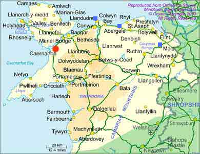
The three blue squares are at Mold, Abergele and the Great Orme. Abergele is closer to the copper mine than Mold is. Did some of the Vinca make it to Wales, take up mining copper, and become wealthy enough to have the gold cape made?

The picture above shows a painted Vinca vase, the date is not given, but would be before 3200 BCE, and possibly a thousand years older. It has a design made like an M, but it is actually two separate pieces which make up this M. It’s more like a 7 and a backward 7. This sign can be found several times in the script, used several different ways. In this case there is a face above the V. It looks like the Akhet again. The Sun between two mountain peaks. Looks very much like the Akhet on the Folkton Drums. The Balkans are named Old Europe, it had settlements of 2500 people and more, a thousand years before such things show up in Mesopotamia, unless the dates for that area are incorrect. This was a well organized society with orderly villages, farming, fishing, gathering and hunting. There seems to have been enough surplus food so that people had extra time for pottery, weaving, mining and metallurgy. Their religion was based on the Mother Goddess, the Earth and her attendant the Bull/Sun God. That isn’t all that different from Celtic religion with its Triple Goddess, the Earth, and Cernunnos, her stag/man/Sun consort. The bull has been an important symbol since very ancient times. Some of the oldest ‘cult’ figures were small stone bulls made at Mureybet. It figures heavily in Celtic art. The Vinca culture was already a well developed society by 5000 BCE, and may be at the root of all later higher civilizations, such as Sumer, Egypt and Crete. Then again, we haven’t seen everything which will be excavated at Gobekli Tepe as yet. Their stone carving was very advanced for 9000 BCE.

Archaeology is full of puzzles and amazing finds, which are changing our view of the people in ancient times. Thanks to modern technology, anyone can scan the earth for geoglyphs, odd formations, see the different colours in fields, indicating buildings, tumuli, roads, etc. Or they can look at the ocean floor, and spot ancient flooded settlements, old coastlines, ancient lakes and rivers, and sometimes find things which look like roads. It’s a fascinating world, I just wish we knew more about it.

References and Pictures

Gold Mold Cape; The British Museum, Wrexham Museum, Wikipedia

Old Europe by Philip Coppens

Vinca Culture; Projekat Rastko: and Professor Nenad Tasic about Vinca and world archaeology, from examiner.com

Vinca footed bowl and article, Internet Library of Serbian Culture: Archaeology.

Vinca vase from Oracle ThinkQuest

Vinca Culture, Wikipedia

Vinca symbols, Wikipedia

Old Europe (archaeology) Wikipedia

Map of Neolithic expansion, Wikipedia

Genetic History of the British Isles, Wikipedia

Proto-Indo-European-Language, Wikipedia

House on Jura, theisleofjura.co.uk

Map of North Wales, touristnet.uk.com