The Stonehenge Carvings

This is an updated version of our original paper Stonehenge Carvings. We discovered some small errors which had been overlooked although I’m sure we read through everything dozens of times.


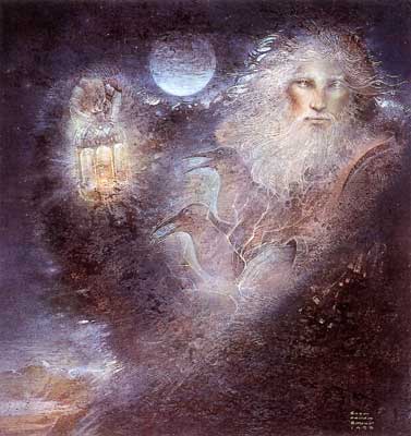
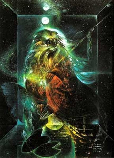
Forest Spirit by Susan Seddon Boulet

                   Forest Spirit by Susan Seddon Boulet

Greetings from Cape Breton. At last I have made the figure 8 back to my blog.

Two and a half years ago a gentleman named Lloyd Matthews wrote to me about some carvings he believed were original to the stone monument at Stonehenge. Did I know what they might mean?

No, I had no idea that they existed. I haven’t been to Stonehenge, so never had a chance to have a good look at the stones. Like most people who are interested in Stonehenge, I knew about the carvings of the axe heads and the Mycenaean knife but knew nothing about the carvings Mr. Matthews showed me.

We have put in all this time researching and spending hundreds of hours with our astronomy programs and reading, reading, reading and watching documentaries about Stonehenge. Part way through our project, James Matthews joined us and made sure everything was correctly written and contributed to some of the diagrams. Great stacks of email have crossed the Atlantic since the start of our project, but now we are finished, happy with the outcome of our research.

So now we present it to you , my readers. We hope you will enjoy this paper and I hope that the fact that it is 90 + pages will make up for my two and a half year disappearance. I’m not sure when I will be back but I’ll have something new and interesting. Ancient history is full of interesting things.

Click the link below to read the PDF

Stonehenge Carvings v.6

The Stonehenge Carvings


Forest Spirit by Susan Seddon Boulet

Forest Spirit by Susan Seddon Boulet


Greetings from Cape Breton. At last I have made the figure 8 back to my blog.

Two and a half years ago a gentleman named Lloyd Matthews wrote to me about some carvings he believed were original to the stone monument at Stonehenge. Did I know what they might mean?

No, I had no idea that they existed. I haven’t been to Stonehenge, so I’ve never had a chance to have a good look at the stones. Like most people who are interested in Stonehenge, I knew about the carvings of the axe heads and the Mycenaean knife but knew nothing about the carvings Mr. Matthews showed me.

We have put in all this time researching and spending hundreds of hours with our astronomy programs and reading, reading, reading and watching documentaries about Stonehenge. Part way through our project, James Matthews joined us and made sure everything was correctly written and contributed to some of the diagrams and the research. Great stacks of email have crossed the Atlantic since the start of our project, but now we are finished, happy with the outcome of our research.

So now we present it to you , my readers. We hope you will enjoy this paper and I hope that the fact that it is 90 + pages will make up for my two and a half year disappearance. I’m not sure when I will be back but I’ll have something new and interesting. Ancient history is full of interesting things.

Click the link below to read the pdf.


Stonehenge Carvings v.3 (1)


Following the White Trail to Stonehenge Part VII

Spinning Threads

Spinning Threads

The 56 Aubrey holes at Stonehenge have always been a puzzle, but I found that they could be used as a calendar. Not only for keeping track of days and years, but also for keeping track of planets, stars and eclipses. 56 is a very interesting number, it can be 7 x 8 = 56, 4 x 14 = 56, 2 x 28 = 56. Gerald Hawkins found that eclipse cycles at Stonehenge run 10, 9, 9, 10, 9, 9, years or 19, 19, 18 years. 10 + 9 + 9 + 10 + 9 + 9 = 56. 19 + 19 + 18 = 56. The year, 6.5 x 56 = 364 + 1 = 365. The cycle of Venus which passes between the Sun and the Earth every 584 days 10 x 56 + 24 = 584. The astronomers at Stonehenge were also keeping track of cycles of 72 and 128 years. 72 + 56 = 128. 72 years has to do with cycles of the Zodiac, and every 128 years they were not adding a day for leap year. (1)

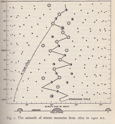
There is a much more interesting number connected to the Aubrey holes. 360° ÷ 56 = 6.4285714°. In the diagram below all the black dots, Suns and Moons are all positions of the full Moon. The ones in the central zone are full Winter Moons which become involved with eclipses of both the Sun and Moon at both the Winter and Summer Solstices. These are not the positions of the actual eclipses. The Winter Sun never comes near the Avenue and the Summer Moon closest to Summer Solstice will eclipse between the uprights of the Great Trilithon.

Hawkins 001

When the Winter Moon is traveling from its Minor to Major position over 18.61 years, it will be in the middle zone every 10, 9, 9 years. When it is  in its Minor or Major position it indicates eclipses close to the Equinoxes, but in the middle zone it indicates eclipses at the Winter and/ or Summer Solstice. By watching the position of the Winter Moon’s rising, the astronomers at Stonehenge would know whether there would be an eclipse close to either the Equinoxes or Solstices. As can be seen, the middle zone is not quite 6.5° wide, it’s more like 6.4285714° wide.

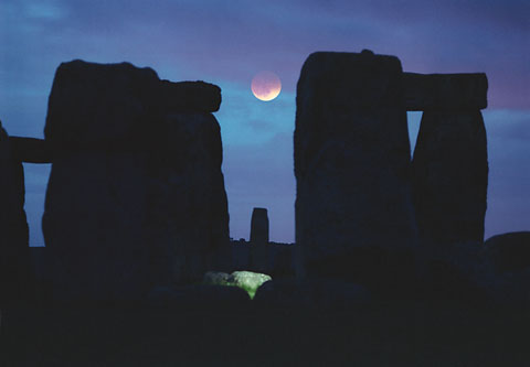
There are several theories about eclipse prediction at Stonehenge and the manner in which it could be done. They all work, but the people at Stonehenge had a much simpler way. If they saw that the Winter Moon indicated an eclipse of the Moon close to Summer Solstice, all they had to do was count the days on their calendar until the full Moon in May. This would tell them when the next full Moon would be in June. Gerald Hawkins was at Stonehenge in 1964, he knew there would be an eclipse of the Moon on June 25. He noticed that the time difference between the Moon’s rising and the Sun’s setting became shorter by almost an hour a day, until June 24 when the Moon rose 15 minutes before the Sun set. Six hours later there was an eclipse of the Moon at around 2 AM, June 25.

stonehengeb Moon eclipse

I checked out this eclipse in 1964 on Cybersky, and what I found was that the first flash of the Moon above the horizon occurred at 8:06 PM and by 2:31:43 AM the Moon had eclipsed and now the first sliver of light was appearing again. 6.4285714 hours = 6 hours, 25 minutes and 43 seconds. This is the amount of time between 8:06 PM and 2:31:43 AM. This time difference between the Moon rising, the Sun setting and the eclipse will always be the same, except that the time of the eclipse would be different on June 10 than it would be on June 22, because on June 10 the Moon will rise earlier and the Sun set earlier, and so the eclipse will also be earlier. There is also a limit to the time difference between Moonrise and Sunrise for an eclipse of the Sun. If the Moon rises too long before Sunrise, the Sun will not have time to catch up to the Moon for an eclipse. That is what actually happens for an eclipse of the Sun. The Sun is traveling faster than the Moon and it passes behind the Moon to become eclipsed.

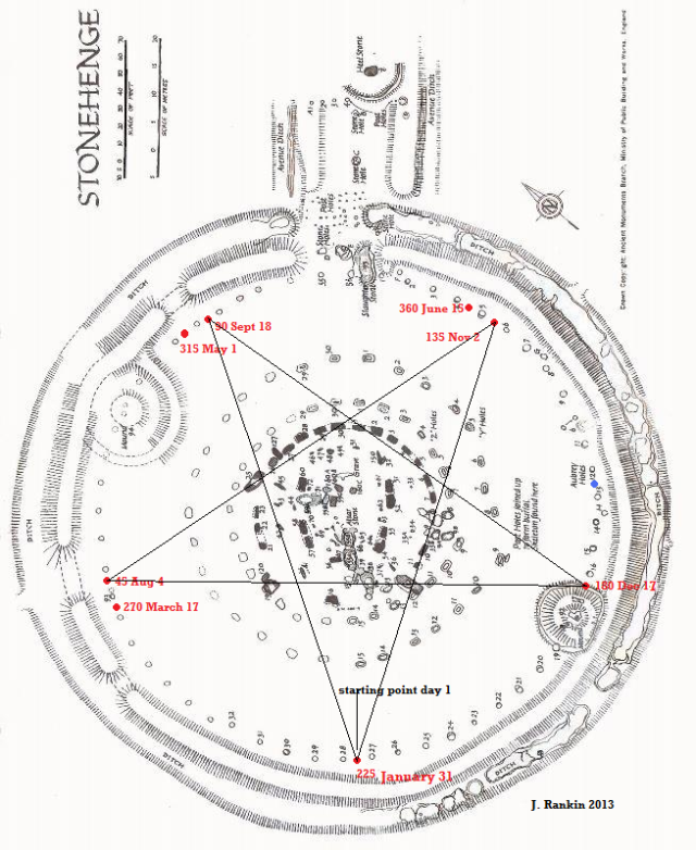
There is one other thing which I discovered about this magic number 6.4285714. I was so curious about it that I looked it up on line just to see if something would come up about this. And it did. 45 days = 6.4285714 weeks. What was the meaning of this 45 days? New Years day of the Stonehenge calendar was June 21. At Sunset that evening a marker was placed between Aubrey holes 28-27, this was to mark the first day. The marker then travelled counter-clockwise, not being moved until Sunset of each day. Including June 21 as day 1, 45 days will take you to August 4, day 90 is September 18, day 135 is November 2, day 180 is December 17, day 225 is January 31, day 270 is March 17, day 315 is May 1, day 360 is June 15. 8 x 45 = 360 + 5 = 365. It is likely that they had permanent mark stones at these eight places on the Aubrey hole circle. Perhaps painted different colours, or painted with different symbols which would tell them which day it was when they came to one.45 day cycle

Our modern quarter and cross quarter days are June 21, August 1, September 21, October 31, December 21, February 2, March 21, and May 1. The quarter days are in June, September, December and March, these are the Solstices and Equinoxes. Trying to pinpoint the exact day of the Solstices just by observing Sunrise is very difficult because the Sun seems to stand still for several days before you will notice the movement in the other direction again. But at Stonehenge they had their calendar to tell them when the exact day was. Including June 21, it is 184 days until Sunset of the Winter Solstice. You can see where day 180 is, in three days the marker would be between 13-14 at H. The next morning will be the Sunrise of Winter Solstice which in 3000 and 2500 BCE would appear at 130.48° and 130.39° which fall between 12-13 marked by the blue dot. At Sundown your marker will be between 12-13, and you will have counted 184 days The folks at Stonehenge seem to have been keeping a calendar of 8 periods of 45 days each, plus 5 days.

One of the most interesting outcomes of this plotting of the 45 days is that when the lowest five numbers are connected, they create a pentagram which in this case  becomes a pentacle since it is inside a circle. The oldest representation of a pentagram comes from Mesopotamia 3000 BCE, but it seems the folks at Stonehenge already had one in 3154 BCE when their calendar started. There is a great deal of symbolism attached to both the pentagram and pentacle which exists among many cultures in the world. However, the most important thing about this one at Stonehenge is that it shows a direct link between astronomy and geometry. It was astronomy and the counting of those 45 day periods on 56 places which created the pentagram.

The magic number 6.4285714 does play a great part at Stonehenge. It’s the number of degrees between Aubrey holes. It’s the number of degrees of the Moon/Sun indicator eclipse zone on the Avenue. It is the hours, minutes and seconds between first flash of the Moon’s rising and the first sliver of light of the Moon as the eclipse started passing away again. And last, but not least, it represents 45 days which divided the Aubrey hole circle into the quarters and cross quarters of the year. The layout for the 56 Aubrey holes was also created using astronomy. (2) It would seem that right from the beginning Stonehenge was all about astronomy. So far I have not found any use of higher mathematics here, nor did they use any complicated geometry. The pentagram was only the outcome of the 45 day cycle.

References

Stonehenge Decoded by Gerald Hawkins in collaboration with John B. White

Cybersky

Sun Moon Lozenge Applet by J. Giessen

(1) Following the White Trail to Stonehenge Part II

(2) Following the White Trail to Stonehenge Part I

Diagrams and pictures

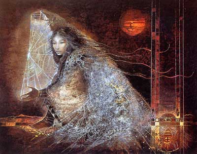
Spider Woman 1986 painting by Susan Seddon Boulet

Stonehenge Decoded by Gerald Hawkins in collaboration with John B. White

Moon eclipse at Stonehenge from astroprints.com/Stonehenge.htm

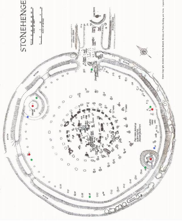
Groundplan of Stonehenge from the Ancient Monuments Branch, Ministry of Public Buildings and Works, England. Additions by J. Rankin

The Navigators

“This book contains the story of the discovery of the first hard evidence that advanced peoples preceded all the peoples now known to history. In one field, ancient sea charts, it appears that accurate information has been handed down from people to people. It appears that the charts must have originated with a people unknown, that they were passed on, perhaps by the Minoans (the Sea Kings of ancient Crete) and the Phoenicians, who were but a thousand years and more the greatest sailors of the ancient world.” (1)

So begins Charles Hapgood’s book Maps of the Ancient Sea Kings. He and his students at Keen State College undertook to analyse the Piri Re’is Map of 1513. Charles Hapgood, his students and several other experts in astronomy, mathematics, history and map making spent seven years analyzing not only the Piri Re’is Map but many other ancient maps also.

                                                               The Piri Re’is Map of 1513

John K. Wright, past director of the American Geographical Society had the following to say about this book:

“The geographer and geologist William Morris once discussed “The Value of Outrages Geological Hypotheses” * His point was that such hypotheses arouse interest, invite attack, and thus serve useful fermentative purposes in advancement of geology. Mr. Hapgood will agree, I am sure, that this book records a mighty proliferation of outrages cartographical and historical hypotheses, as luxuriant as an equatorial vine. His hypotheses will “outrage” the conservative instincts of the historically minded cartographers and cartographically minded historians. But while those in whom conservatism predominates will react to this book like bulls to red rags, those of radical, iconoclastic bent of mind will react like bees to honeysuckle, and the liberals in between will experience a feeling of stimulating bafflement.

A map dating from 1513, and by the Turkish Admiral, Piri Re’is, is the seed from which the vine has grown. Only the western half of the map has been preserved. It shows the Atlantic coasts from France to the Caribbean on the north to what Hapgood (following Captain A. H. Mallery) holds to be Antarctica on the south; and of course any proposition that any part of Antarctica could have been mapped before 1513 is startling. But yet more startling are the further propositions that have arisen from the intensive studies  that Mr. Hapgood and his students have made of this and other medieval and early modern maps. These studies which took seven years, have convinced him that the maps were derived from prototypes drawn in pre-Hellenic times (perhaps even as early as the last Ice Age). That these older maps were based upon a sophisticated understanding of spherical trigonometry of map projections, and – what seems even more incredible – upon a detailed and accurate knowledge of latitudes and longitudes of coastal features throughout a large part of the world.” (2)

Charles Hapgood, his students and many others connected to this project came to the conclusion that there must have been an older, more scientific culture in ancient times than what we are aware of. One which was well acquainted with astronomy, higher mathematics, surveying and navigation. This doesn’t mean that this culture may have been a high-tech one such as our own, only that there were well educated people who likely did live in a high culture. Hapgood explained such maps as the one by Oronteus Finaeus, dating 1531, as a compilation of many small maps which had been gathered together over time. Many of these old maps have details of the interiors of countries which could only have been gathered  by people surveying by land.

                                                                The Oronteus Finaeus Map 1531

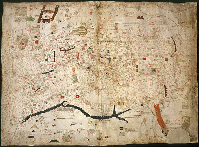
Like all other theories this one is still hotly debated, but as Hapgood says in his book “you find what you look for”.  By this he meant that up until his time few people had ever considered that there had been a high civilization with astronomers, mathematicians, surveyors and navigators in ancient times, so ancient that we have no records of them. Of course, some of the records are still there in the ancient sea charts, and in the ancient megalithic constructions on land. But regardless of whether you believe that there was such a civilization or not, there are hard to explain things about some of the maps.  One of the standard maps used in medieval times was the portolan chart. So called because they took mariners from port to port. The Dulcert Portolano of 1339 is one such map.

                                                                          The Dulcert Portolano

These maps usually cover Europe and the lands around the Mediterranean. The longitudes and latitudes seem to be much more correct on the older versions rather than the later ones. The theory being that these maps were copied and recopied by several different people. There were a great many documents and maps destroyed at the library of Alexandria when the contents were burned several times. The old libraries of Carthage and other old cities are also believed to have been destroyed by one group or another during various wars. These libraries housed records about history, literature, mathematics, astronomy, surveying, architecture, medicine, maps and navigation to name but a few things. A great deal of the written word has been lost due to new ideas coming along, some religious, some not. Book burnings still happen, and people still scrap books from libraries if they don’t consider them fit………….according to their way of thinking.

What is puzzling about these maps is the longitude. The question being, “How did people in ancient times find longitude?” The chronometer was not invented until the eighteenth century. Before that, longitude was quite a puzzle for many hundreds of years. But long before that, it doesn’t seem to have been a puzzle at all. The people who built the Temple at Stonehenge c2500 BCE knew about it. There’s a line of light there which shows up just before noon. It gradually gets smaller and smaller, until it disappears. It is then apparent noon at Stonehenge, and the line of light sits N/S. A longitude line every day. There are many things on the landscape which show that these people understood longitude. Avebury and Silbury Hill are directly north of Stonehenge. Arbor Low and its egg-shaped recumbent white stone ‘circle’ is 2° north of Stonehenge. Callanish is 5° north and 5° west of Arbor Low. Holy Island is 4° north of Stonehenge. Glastonbury Tor is 1° west of Stonehenge. Oddly enough things do seem to have been placed on the landscape by degrees, both latitude and longitude. The ancients were measuring the globe in 360°.

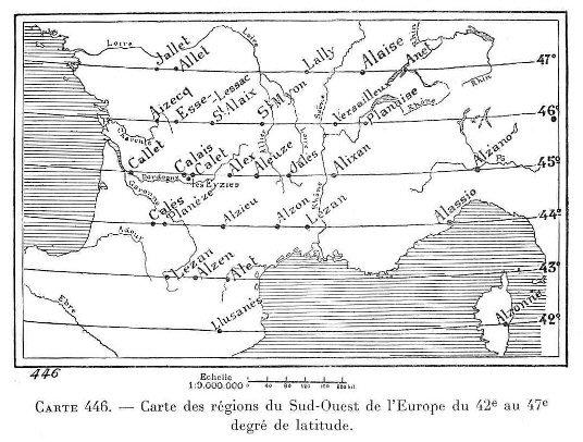
This sort of geodesy is not confined to Great Britain and Ireland, but can be found in many places on the globe. One of the most interesting places is France and some of the surrounding countries. Right about the time Alfred Watkins was hunting old straight tracks in England, a French detective named Xavier Guichard began a personal investigation into the roots of place names in France. His research led him to conclude that locations with the root-name ‘Alaise’ had once belonged to a network of alignments which extended throughout France, and other areas in Europe, through longitude and latitude. He concluded that he had touched on the Eleusian mysteries of ancient Greece. Unfortunately he and Alfred Watkins didn’t know each other or about their individual searches. 

Alaise, France is at 47° 00′ N, 5° 58′ E, and Eleusis Greece is at 38° 00′ N, 18° 00′ E. The two sites are separated by 9° latitude and 12° longitude.

“Of particular relevance is the fact that Guichard’s research uncovered the fact that Aleusian sites were separated by units of degrees of longitude and latitude, a notion which suggests an understanding of higher geometry and several other sciences. Guichard’s research has traditionally been scorned by mainstream historians, but independent research confirms his data, and much of his original theory.” (3)

The independent research is being done by Alex Whitaker of Ancient-Wisdom.co.uk. All the data can be viewed on his site. He has checked mainly primary locations, plus one secondary one.

Out of 48 primary places, the latitude for 32 were confirmed correct. The other 16 were not found. However, some place names have changed since Guichard’s day, spellings also. Llussa, Spain is now Lluca. Alex in France is now Aleix, and Leysele, Belgium is now Leisele. Although Mr. Whitaker has only 31 confirmed because he could not find Alzonne on Corsica, I found Ajaccio on Corsica which is at the correct latitude. I think perhaps Guichard made a mistake with the name. Alzonne is a department in France. This is why I have 32 as confirmed.

Out of 18 primary places, Mr. Whitaker found 14 correct for longitude. Some of the other locations were not found, and he is still researching this project. The Eleusian Mysteries are thought to have included higher mathematics, astronomy, and geo-metry, which is the measurement  of the earth or surveying. It also included Oracles who would have to understand astronomy since ancient oracles were generally astrologers. Guichard’s findings are thought to have been created in prehistoric times, long before there was a country named Greece.

A land map that Charles Hapgood looked at was one from China which had been carved in stone in 1137 CE, although it is believed to be a copy of a much older map. He found a copy of this map in Science and Civilization in China by Joseph Needham. By analyzing this map he found the following for latitude and longitude by quadrant of the map.

Northwest quadrant, 8 locations, average errors 0.4° Lat. 0.0° Long.

Northeast quadrant, 10 locations, average errors 0.0° Lat. 0.0° Long.

Southwest quadrant, 9 locations, average errors 1.3° Lat 1.2° Long.

Southeast quadrant, 7 locations, average errors 0.0° Lat. 1.2° Long.

The small amount of error is considered negligible because of the great area this map covers. Charles Hapgood: 

“Here we have evidence that when this ancient map of China was first drawn, mapmakers had a means of finding longitude as accurately as they found latitude, exactly as was the case with the portolan charts in the West. The accuracy of the map suggests the use of spherical trigonometry, and the form of the grid, so like that of the De Canerio Map, suggests that the original projection might have been based on spherical trigonometry.

As a further test of the grid I had drawn for this map, I listed separately all the northernmost and southernmost places identified on the map and averaged their errors in latitude. I also listed all the easternmost and westernmost places and averaged their errors in longitude. The average error of latitude north was less than one-half of one degree (or 30 miles!), and the average error on the south balanced out to zero ( with four localities 1° too far south and four 1.2° too far north). So far as the longitude was concerned, the errors both east and west balance out to zero. There was no indication, therefore, that the grid constructed on the map was seriously in error.

It seems to me that the evidence of this map points to the existence in very ancient times of a worldwide civilization, the mapmakers of which mapped virtually the entire globe with a uniform general level of technology, with similar methods, equal knowledge of mathematics, and probably the same sort of instruments. I regard the Chinese map a capstone of the structure I have erected in this book. For me it settles the question as to whether the ancient culture that penetrated Antarctica, and originated all the ancient western maps, was indeed worldwide.”

Oronteus Finaeus’ map shows Antarctica, partly bare of ice. It shows the coastal mountain ranges and open rivers flowing down to the sea. Geologists have taken core samples from the Ross Sea which suggests that Antarctica had a temperate climate before 6000 years ago. The core samples show that there were several periods of glaciation with times of temperate climate in between. This doesn’t necessarily mean that all of Antarctica was ice free, only that the icecap may have been smaller at such times. Geologists are still puzzled by the cause of Ice Ages, and the last one melted so fast that there really is no conclusion why this was. There are theories, one is Charles Hapgood’s Earth crust displacement theory. He theorised that the Earth’s crust slipped south about 2000 miles due to the enormous weight of the ice covering much of the northern hemisphere. While Europe and North America slipped south, the other side of the globe slipped north. There is another theory which states that the Earth was hit by two meteors, which put things on Earth at a different latitude, and also caused the rapid melting of ice, and a general sloshing about of all water on Earth. This sort of event would also have caused flooding, earthquakes and erupting volcanoes. Some major event does seem to have happened resulting in a great deal of havoc at the end of the last Ice Age with much flooding, earthquakes and volcanoes erupting. The whole story is likely hiding within World mythologies.

Antarctica is shown much too large on Oronteus Finaeus’ map. Charles Hapgood felt that this was due to the map having been put together using many smaller maps, and that Oronteus has shown Antarctica in a different scale from other locations. He didn’t adjust the scale to match the rest of the map. On Piri Re’is’ map, Hapgood’s students discovered 900 miles of coast missing in South America. The northern part was good and the southern part was good, but in between there was 900 miles of coast missing. One of the smaller maps had gone missing obviously. No Europeans, as far as we know, explored or mapped the east coast of South America by 1513, but obviously someone did at one time, or Piri Re’is wouldn’t have it on his map.

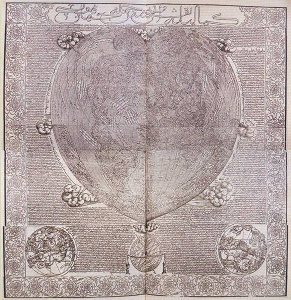
                                                           The Hadji Amhed World Map of 1559

On the Hadji Amhed World Map of 1559, we see all of North America and South America, looking very modern indeed. He even shows the Bering Land Bridge which existed during the last Ice Age. But no one in 1559 knew that there had been an Ice Age or that there had been a land bridge between Alaska and Russia. Nor had any modern explorers been to the west coast of North America to be able to map it. It even shows the Gulf of California and the narrow strip of land south of San Diego.  He also shows Antarctica, but also much too big. These old maps which do show Antarctica, all have it too big, and they all have it almost connected to South America. It would seem that all these people must have used the same source maps, but no one adjusted the scale, since no one in their time had even seen Antarctica. Captain Cook was convinced that it existed when he went looking for it. He failed on his first attempt, likely because he was looking too close to South America, and wasn’t far enough south.

No one is too sure as to when the original maps may have been made. Derek Cunningham suggests that it was started right after most of the ice had melted. He felt it was sometime between 12,000 BCE and 10,000 BCE. Charles Hapgood felt it had started after the last Ice Age also. If a catastrophe with world wide implications did happen at one time, it is possible that the stars you were used to seeing overhead may no longer have been the same. If there were astronomers, surveyors and navigators at that point in time, they would have to start their astronomical observations from scratch again. If, as the histories and science tell us, there was an enormous amount of flooding after the last Ice Age, things changed, land masses changed. All land masses had their coasts changed. Enormous lakes appeared where no lakes existed before. The Black Sea was once a fresh water lake until the land bridge at the Dardanelles gave way, then it became a salty sea. Coastal towns and villages which may have existed disappeared below the water. There are towns which existed thousands of years ago which archaeologists are just discovering. These places were built well after the Ice Age ended. Most of Doggerland disappeared in 6200 BCE, and Doggerbanks was gone by 5200 BCE. How many people were lost during these events, and where did the survivors go? So far I have not seen a map with either Doggerland or Doggerbanks on it, but perhaps someone removed them from the later maps.

Charles Hapgood:

“The reader will quite naturally wonder how, if once a great civilization existed over most of the earth, it could disappear leaving no trace except these maps? For an answer to this we must cite one of the best known principles of human psychology: We find what we look for. I do not mean by this that we never find anything by accident. But rather, we usually overlook, neglect, and pass by facts unless we have a motive to notice them. It was Darwin who said that to make new discoveries one had to have a theory ( not a fixed dogmatic theory, of course, but an experimental hypothesis). With the theory of evolution people began to look in new directions, and they found new facts, by the thousands, which supported and verified the theory. The same thing happened a half-century before with the geological theory of Sir Charles Lyell. It happened in the beginning with modern astronomy, when Copernicus proposed a new theory of the solar system. Hitherto people have not seriously believed that an advanced civilization could have preceded the civilizations not known to us. The evidences have been, therefore, neglected.

But if we take a glance at the history of archaeological research in the 19th Century we see that it consists mainly of the rediscovery of lost civilizations. Jaquetta Hawkes (4), in her fascinating anthology of the writings of some of the principal archaeologists of all periods, devotes a section to “Lost Civilizations.”

The story begins in Mesopotamia, about 1811, when Caudius Rich began a rediscovery of Babylon. It continued with Paul Emile Botta, Henry Layard, and Henry Rawlinson who brought Assyria back into history. Egypt came back into history after Champollion solved the problem of Egyptian hieroglyphics, and in the fourth quarter of the century, Schliemann brought Troy out of the mists of legend, and Sir Arthur Evans gave substance to the myths of Crete. More recently still an advanced culture, with strangely modern luxuries, that flourished on the banks of the Indus River 5000 years ago has joined the ranks of lost civilizations rediscovered.

But is this all? Is the process at an end? Are there no more lost civilizations waiting to be rediscovered? It would be contrary to history itself if this were the case. Unimaginative people made fun of all these discoveries in turn and hounded the discoverers. The same sort of person today accepts all that has been discovered in the past, but denies there is anything more to discover.

Let us start our review of the evidences with Egypt. Scholars are in disagreement about particular achievements of the Egyptians in science, but they are in good agreement about particular aspects of them.  Egyptian knowledge of astronomy and geometry as early as the Fourth Dynasty has been shown to be remarkable. The Egyptians had a double calendar which has been described as “the most scientific combination of calendars that has yet been used by man”. This calendar system may have been in use as early as 4241 B.C. One historian writes: “It may be, as some indeed suspect, that science we see at the dawn of  recorded history was not science at its dawn but represents the remnants of the science of some great and as yet untraced civilization”. (5)  

To date we have not found that civilization, but a great many things have been found since 1966 when Charles Hapgood wrote those words. Among them are Gobekli Tepe in Turkey, the houses at Durrington Walls in England, and most of what is being found in the Orkneys. Gobekli Tepe is one of the big puzzles because of all the carved stone which has been found there, and the fact that people do seem to have buried the place completely for some unknown reason. It is being dated c9000 BCE, and such stone carving doesn’t show up again until thousands of years later.This seems rather odd, and one would expect more of it to turn up sooner or later.

Durrington Walls is part of the Stonehenge Complex. It includes Windmill Hill, Avebury Ring, Silbury Hill, the Sanctuary, Woodhenge, the West Kennet Long Barrow, the Cursus, Durrington Walls, Bluestonehenge and Stonehenge. And whatever may be lying in hiding at the moment. Martin Doutré of Ancient Celtic New Zealand theorizes that this complex was an ancient navigational school. He feels that the Boyne Valley Complex in Ireland and the Ness Brodgar Complex in Orkney were also navigational schools. His mathematics on the subject are very convincing.

However, I find this view somewhat narrow. Since navigation has its roots in astronomy it is quite likely that astronomy, surveying  and map making were taught also. Oracles were very popular at the time, but ancient oracles were usually astrologers hence they had to learn astronomy first before proceeding on with their chosen profession. If you wanted to run a calendar circle in your area, you would first have to learn astronomy.

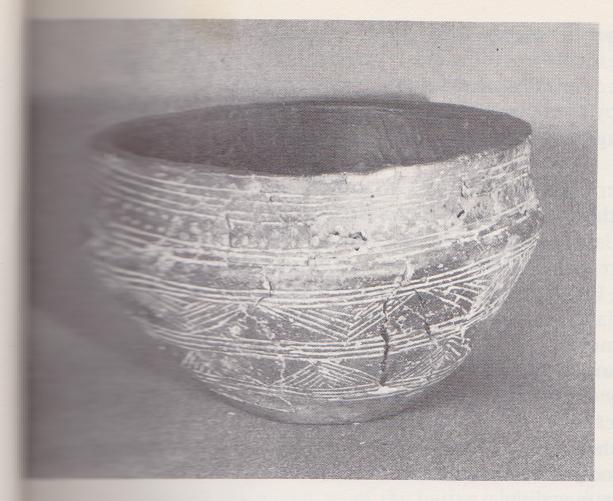
The houses at Durrington Walls are believed to have been only seasonal accommodations because no querns or carbonized grain was found within them. But like Skara Brae, all the cooking and baking may have been done at one central kitchen, which may not have been found as yet. I did find a very interesting Grooved Ware bowl from Durrington Walls c2500 BCE which may have been a latitude memory device.

                                                 Grooved  Ware bowl from Durrington Walls  

The parallel lines running around this bowl are lines of latitude. Starting at the top the lines are 65°N Iceland, 60°N Shetland, 55°N Holy Island and Bornholm Island which is also at 15°E, 50°N the tip of Cornwall. The space between these and the next group of three lines is 15°. The three lines are 35°N Morocco, Algeria, Tunisia, Crete and Cyprus, 30°N Giza, 25°N the Dakhleh Oasis where the stone circle at Nabta Playa is. The next space is 20°. The next group of lines are 5°N which runs along the south coast of north-western Africa, the Equator, 5°S Lake Victoria. The next space down is 20°. The next group of lines are 25°S, 30°S, 35°S and 40°S. 25°S and 30°S run through Australia, 35°S runs through the passage between Australia and Tasmania, 40°S runs through New Zealand. The next space is 15°. The last four lines are 55°S the tip of South America, 60°S South Orkney Island, 65°S runs through the long narrow tail of Antarctica, 70°S Antarctica.

If this was a memory device, it only took me a few minutes to remember. If it was in front of your nose every day, you’d remember. And obviously they were interested in more that just the Northern Hemisphere, they even included Antarctica.  There are likely many more interesting places along these latitudes, but think these are quite good. Have a look at some maps yourself, and see what other interesting things can be found at these latitudes. 

Sources

* William Morris Davis from Science, vol. 63, 1926, pp. 463-468

(1) Charles Hapgood, Maps of the Ancient Sea Kings

(2) John K. Wright, author and past president of the American Geographical Society

(3) Alex Whitaker, Ancient-Wisdom.co.uk

(4) Jaquetta Hawkes, The World of the Past

(5) S. R. K. Glanville, Legacy of Egypt

Xavier Guichard, Eleusis Alesia: Enquête sur le origines de la civilisation européenne, 1936, detective, archaeologist and writer.

Martin Doutré, Ancient Celtic New Zealand

Alex Whitaker, Ancient-Wisdom.co.uk

Pictures

Rune Master by Susan Seddon Boulet

The Piri Re’is Map 1513 from sacred-text.com

Oronteus Finaeus World Map from Forbidden History

Dulcert Portolano, Wikipedia

Hadji Amhed World map 1559, Wikipedia

Longitude and latitude maps of France by Xavier Guichard found at Ancient-Wisdom.co.uk

Picture of the Grooved Ware bowl from The Megalith Builders by Dr. Euan MacKie, with permission from Dr. MacKie

The Amazing Book of Kells II

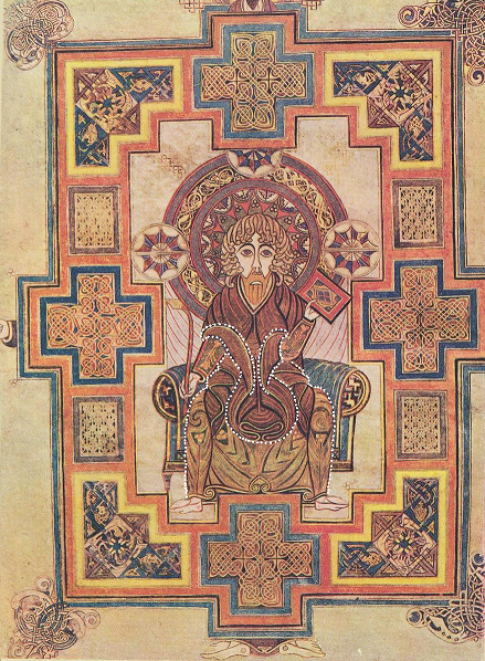
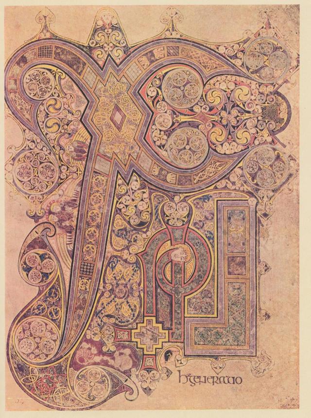
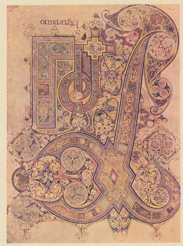
The Chi Rho or XPI page

Since it has been raining here for several days, I’ve had some spare time to assemble the pictures I wanted to use for this post. I’ve taken an interest in Celtic art for some time, I always found it intriguing. After some time, I realized that there were heads and faces in many of the designs. Not only the ones which are obvious but others as well, often made up of triskles or other  swirling designs. The theme of double heads is seen often. Sometimes it’s one head, but if you turn it over, it becomes a different head. Sometimes it’s two men. Sometimes a man and a woman. The two men are the Summer and Winter lords, the man and woman the goddess and her consort.

At the very end of a Celtic art book named Celtic Art by Ruth and Vincent Megaw, there is a picture of the Chi Rho or XPI page in the Book of Kells, and I wondered if Lugh/Cernunnos, or Summer lord -Winter lord had made it to the monasteries. I have a colour copy in a book named The Book of Kells, text by Sir Edward Sullivan. A reproduction of the 1920 version. However, I found a clearer picture on-line. This book has been connected to St. Columba, but it has never been proved. He is said to have worked in a scriptorium in a monastery in Ireland, and that there was a dispute about a manuscript Columba borrowed and copied. Apparently hostilities broke out and several people were killed, resulting in Columba’s exile to Iona.

However, the experts say this book dates about 800 CE, and St. Columba died in 597 CE. I don’t know who created this page, but he knew Ogham and all its meanings, and I think he may have left us a picture of a real Druid. St. Columba was from the Druid tradition, that’s why he is called a Crane Cleric. The crane being Cygnus, and connected to Manannan and his Crane Bag in which he kept his treasures. The treasures being the Ogham tract, including the vowels, consonants and diphthongs, plus the rolled up strip of the Whale’s back. The beginning of Columba’s name is Col. Coll is the Hazel, the Hazels of Wisdom.

The early Church in the UK and Ireland was the Culdee Church. It believed in God, Jesus, Mary, John the Baptist, and followed the Apostles. At the same time they still kept to their old Druid traditions. Most of the men and women connected to the early Culdee Church came from Druid backgrounds, and were already educated in their own traditions before entering a hermitage or monastery. These monasteries had both men and women, and both could become scholars. There was equal rights among them, they could even marry and have children. The earliest Christian writings in the Culdee Church were on Ogham sticks using Ogham, and later on velum and written in Greek. The Druids used Greek also, and Iona was once a Druid mystics’ retreat.

No one has ever disputed that this is the most marvelous page. Everyone is taken by the knot work, triskles, circles, etc. but no one has ever described the following, as far as I know, because no one knew that it was there. I have seen many of the formations before, but didn’t know their significance until now. According to the art book, this page is supposed to say XP, the first two letters of the Greek word Christos. But this artist actually has spelled the word Christos and quite a bit more. According to my Book of Kells, it says XPI, short for the Latin Christes. But this artist used Greek, he used it on another page also. The Druids spoke Greek long before Latin ever came to the British Isles, and I’d say this person came from the Druid tradition even if it was in 800 CE.

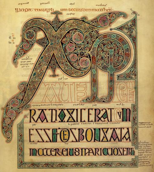
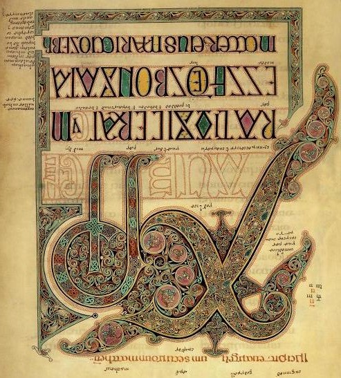
The basic layout for this page is  similar to the XPI page from the Lindisfarne Gospels. We have the big X looking very bird-like, which is meant to be Cygnus, The Swan. Two arms of the X become a turban on an astronomer/astrologer or Druid. I say astronomer and astrologer because he is wearing the propheta head-gear.(1)  On this page the legs of the bird are a straight staff joined to a staff with a curl in it, and a shape like a backward L. Both pages are very beautiful, but the one from Kells has a great deal more detail, and the hidden Ogham, which the one from Lindisfarne doesn’t have, although it does have small hidden pictures.
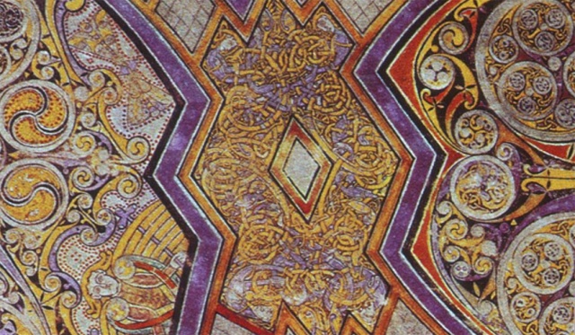
The first thing you notice on this page is the big X. It has the lozenge or diamond of the ‘hidden secret’ symbol in the centre of it. The angles of the smallest lozenge or diamond are 60°  and 120°. Two equilateral triangles back to back. I call this the Double Godhead, because of all the double faces in Celtic art which are usually, but not always, two men. These are the Summer lord and the Winter lord, the two halves of the year, the dark half and the light half. In fact, the artist has gone out of his way to embellish this lozenge with knot work and four men entangled in the knotwork. They represent the four major divisions of the year, the Equinoxes and the Solstices. The whole thing becomes a much bigger diamond shape. Some time ago I discovered that the number four is connected to this shape and the ‘hidden secret’. Here as well. The artist has hidden four letters in the X and has applied Ogham meanings to them. The letters are C, H Ss, and T. Ss because he has used it twice to spell Christos, but it has meaning in Ogham as well. The statement, which St. Columba is said to have made about Jesus being his Druid becomes even clearer on this page. The C is the first letter in Christos but is also the ‘turban’ on what I have been calling a Druid.

The C is the two right arms of the X. C is for Coll, the Hazel, the Hazels of Wisdom which is another way of saying Druid knowledge. Jesus is said to have studied with the priests in Egypt. When he was only young, he was debating with the rabbis at Temple. Well educated even by then, and he was a great orator.
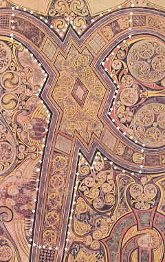
The H is right in the middle of the big X, and is comprised of the diamond and part of the four legs of the X. Right up to where the dark squares with the flowers in them are on the two left legs, but not including them. The flowers are wild Asters in the dark squares, it represents the time after September 21, the start of the dark half of the year. On the long leg of the big X, the light grey square is April, and the rings are May, June, July, August and September. In this case the dark square with the Asters is October, the next ring down is November and the point is December. Church tradition has Jesus born in December. The centre diamond is January, the darker border around it is February, and the part with the gold knot work is March.

The H is for Huathe, the Hawthorn. Its month is April, and that is when Easter usually falls. It is also the month which starts the light half of the year after the Spring Equinox. The first festival in the light half of the year is May 1, when we get Maypoles traditionally decorated with Hawthorn flowers. Garlands were also made with these to decorate the houses. Joseph of Arimathea planted a Hawthorn staff at Glastonbury Tor, it grew and flowered. This letter is connected with a period of waiting, restraint and chastity. Jesus spent forty days in the wilderness before his last visit to Jerusalem.

The Ss is an S used twice. The top part starts on the left hand top part of the X, moves through the diamond and ends with the bottom part of the C. Ss is for Straif, the Blackthorn. The English word, strife, comes from this. It has to do with overcoming great odds with optimism, bringing balance out of chaos…………………much can be said about this in connection with Jesus. You can fill in all your own blanks, since this topic could go on for pages.
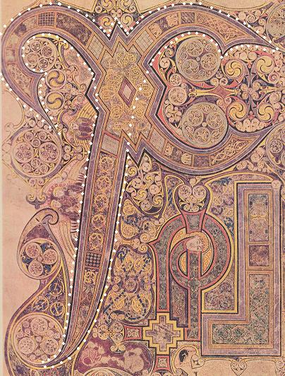
The T is the top of the S, the top of the C and the long leg heading for the bottom left hand side of the page. T is for Tinne, the Holly, which became the Holy Tree because people associated the Holly leaves with the Crown of Thorns. But that isn’t correct. It is the Holy Tree because the cross Christ was nailed to was T-shaped. The Roman’s used a T-shaped device for crucifixion, not the Christian cross we see now. This monk knew that.

Holly is said to be best in the fight, not only spiritual but because spear shafts were made from Holly, and the most important thing about throwing a spear is balance. So it also speaks of equilibrium, and the spear which pierced Christ’s side, but it also speaks of all the other spear imaging we see with Lugh, Wodin and many other Sun gods. Holly is also a symbol of fertility, and here the long point of the T is placing an egg on the Mound of Creation which, as in the book from Lindisfarne, has the head of an ibis. This is that wee story: Thoth as the Ibis laid an egg on the Mound of Creation, which was Hathor as the Milky Way. From the egg, Ra, the Sun god was born. Thoth as the Ibis is Cygnus, which sits on the Milky Way.
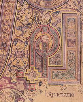
The O, I and R are at the bottom of the page. What is usually referred to as P is actually a glyph, making up P (for the casual observer), R and O. In very old manuscripts P was often written more like a B. But the monk has used a wake up device here to alert you to the hidden depths. Not only do the letters O, I, R belong to the word Christos, but it is also the name of an Ogham letter, Oir or the Spindle tree, whose symbol in the Ogham tract is a square with its corners turned to the cardinal points. I call this the Square of Enlightenment. The O is shaped like a stepped square and is holding together the two legs of the R, showing that these two belong together. The I is the shape which looks like a backward L. 

For O he has used Oir, the Spindle. It is connected to that sudden flash of insight and lightning. In fact, it was the clue to this glyph. He has made it stepped and yellow, suggestive of lightning. This is also the shape of the Andean Cross which is symbolic of the Southern Cross. This constellation was used by mariners, as was the Northern Cross which is Cygnus.  Spindle wood was made into spindles, bobbins and pegs. In this picture he has pegged the two legs of the R together with it. A joiner or carpenter, which is what Jesus was.  He is also connected to enlightenment. Although Jesus was not born on December 25, we celebrate his birth at this time of year because people continued to celebrate this time of the year. In England it was referred to as Yule, and it was to welcome the Holly Lord, who long ago was Cernunnos. We still refer to this time of year as The Coming of the Light. Today it has a multi-layered meaning which comes to us from the time when people first took note of this return of longer days. A tradition which has endured over many thousands of years.

The R is made up of two elements, but the monk has shown us that they belong together by joining them at the bottom with Oir. R is Ruis, the Elder, the end in the beginning and the beginning in the end, the Cauldron of Immortality. The two elements which make up the R are what looks like a P and an I. The P is Phagos, the Hook, old knowledge, old writing, and also a star watching – surveying instrument. The I is the measuring rod and is also a Rodman or Dodman. If both of these were astronomy and surveying devices, then it speaks of the Star of Bethlehem also.

The measuring rod is straight until it gets to the top where it becomes more circular in the space between the bottom of C and the top of P. There’s a face there made up of circles and triskles. He uses them in all his half hidden meanings. The head seems to be covered by a hood, and from the top of it there are two long antennas with balls on the ends. The right one sits over the I, and the left one becomes part of a torque sitting under the chin of another face made of  more circles and triskles and bird shapes. This face is Cernunnos. He has two horns on his head, and Cernunnos was often shown wearing a torque. I’ll come back to him, but first look at the I which looks like a backward L.

The I is Ioho, the Yew, which stands for rebirth, everlasting and reincarnation. According to my Ogham book, the Island of Iona first started off as Ioho or Ioha, but that there was an error in transcription made in the fifth century, and it became Iona instead. This island is connected to reincarnation. Jesus is the new Cauldron of Immortality, symbolized by the Holy Grail, and he is connected to rebirth and everlasting.  The early Church still believed in reincarnation, but I don’t think they do anymore. The, I, the monk has made is shaped like a carpenter’s square.

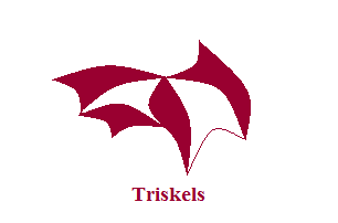
Below are examples of two types of bird shapes this monk used in his decorations.
The monk also has many things made up of circles, triskles and other bird shapes, one of those things is ibis heads. On Thoth, it has  the long curved bill. There is one under the top curve of the S. There’s a big ibis head close to the two angels, there’s wonderful knotwork inside of the head.. She has her beak curved around a circle, which I’ll call an egg, which has three small flying cranes inside it.

There is another ibis head close to the bottom of T, it’s sort of lying down. It also has its beak around an egg containing more small cranes. The two eggs they are holding have cranes at a different stage of development inside them. I say cranes because the bill is straight and long. These two heads are part of the Mound of Creation where there is another egg being deposited by the wingtip of Cygnus. This egg has yellow birds which are hardly developed and there is much more white in the egg. Here is that story about Ra again. Thoth as the Ibis (Cygnus) laid an egg on the Mound of Creation which was Hathor as the Milky Way. Ra, the Sun god, was born of that egg.
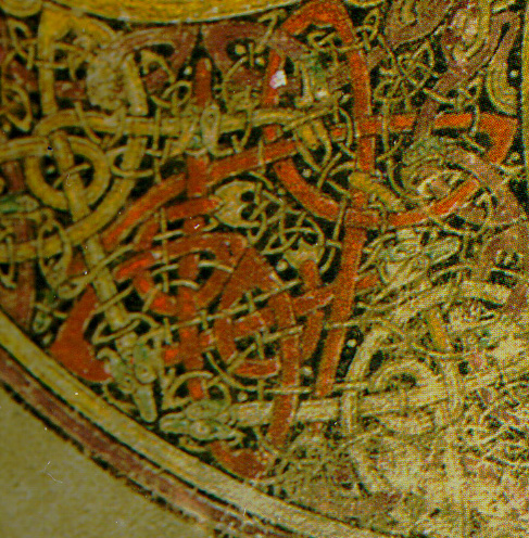
In the bottom left hand corner detail we see a baby (red serpents) emerging from the womb (white serpents). This would be Jesus who the Church says was born at the end of December. The point of the letter T is the end of December.
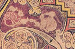
The fat cats and the little rats seem quite cozy together. They’re the abbots and the monks who fell in line with them. They are nibbling on the Pearl of Wisdom, the knowledge they were gaining in the monastery. No doubt, a wee Celtic joke on this artist’s part. The corner detail of this page also implies that two ibis hatched new cranes together. They are also inside some of the other circles, and in some cases there is what looks like a bird flying toward or away from you.
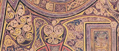
On the left, Cernunnos has two cranes close to the top of his head, they make a sort of crown. There are two more on his cheekbones. He has two flying birds making up his nose, and two more holding the plumes of his headdress. Some of these flying birds are light like the crane and some are dark like the raven.
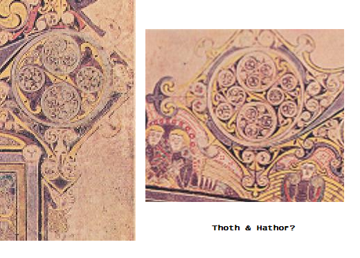
There are also heads of cattle there, also made up of circles, triskles and flying birds. One is between the angels. There are two more there making up the corners of the decoration around a circle with more cranes or ibis inside it. Unfortunately the outside one was cut off below the eyes. The one on the left is hanging off the Druids earring, close to the top of the I. This could be Taurus, or a connection to Bull El/ El Elyon, who was the god Enlil of the Sumerians. Elion is a Welsh name for God, it is still in the dictionary, although I’m told that it is seldom used.  It was Enlil who taught people to farm, he put them to work in the Garden of Eden. At one time, the oldest cult figures found were small stone bulls from Mureybet, home of Jasmine, whose descendents made their way to the UK and Ireland, and were found at Skara Brae in the Orkneys. As far as I know, Mureybet still stands as the oldest farming community  anywhere. The two cattle above could also be symbolic of Thoth and Hathor, both are shown with cattle horns, and both often have the Moon above their heads. Bulls, male goats, rams and harts or roebuck are all connected to ancient Sun gods. There was a great deal of cattle veneration in ancient times, from the Indus Valley to Ireland. Cattle are still sacred in India, and Celts loved owning large herds of cattle, which they often stole off one another. The Wessex lords are also believed to have been cattle barons, and my guess is that the folks at Ness Brodgar were also. There were a great many cattle bones found there.
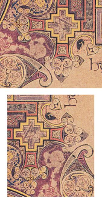
I think the artist may have cartoonish representations of Bran and Branwen. They are the Raven and the White/ female Raven. He is at the bottom of Phagos, the Hook – old knowledge, old writing. She is at the bottom of the measuring rod which could also be a surveying staff. They both look as if they are wearing a red hat with white knot work. I hesitate to say Fez, but they do look like that. She has blonde curly hair, has two trinity knots on her face, and a light coloured bird on her forehead. She also has a baby bird close to her curls on one side of her head. This would be Gwern, her son. The baby bird is two triskles joined at two corners. Lugh, Apollo and Wodin were also connected to ravens. I read that the small animal above Bran’s head is meant to be a badger with a fish. The fish is symbolic of Christianity, and Jesus was a ‘fisher of men’. But Bran, who is much older, is believed to be the Fisher King. Like the Fisher King, Bran was wounded in a lower limb, a wound which never healed, since it brought about his death.
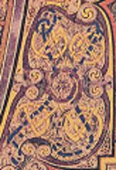
The X symbol for the sacred place is in the knot work between the leg of T and the R.  The big X makes the whole page the sacred place, but the area in which the blue X is, looks like the Station Stone quadrangle at Stonehenge, including the Temple in the middle, and the Station Stones at the ends of the X.

To me, one of the most marvelous things one the page is the Druid. The C of Christos now becomes the headdress on the Druid. He has two big circles for eyes which have trinity knots in them, and the bridge of his nose is made up of ibis. Two big ones and two small ones. The tip of his nose is below the small ones, and his nostrils flare out into circles. Below the nose he has a moustache which also flares out in circles. His mouth is below the moustache, and is made up partly by two cranes whose beaks run down into his beard. His beard is mostly curly but the centre bottom part is divided and turned into knot work, which has been made into three diamonds inside one another with two parallel lines crossing two parallel lines woven into the diamonds, and they make up the symbol for the hidden secret. There are three diamonds inside one another and then the parallel lines inside the smallest one. This is exactly like the design on the Wessex lords ‘breast plate’, which has four diamonds inside one another. The outside one contains triangles, and the centre one the two sets of parallel lines. (2)

There are three ibis above one of the Druid’s eyes. The red band below his turban looks  like an M when he is facing you, but looks like an E when the page is right side up. The artist could be suggesting that this is Manannan since the M shows up when he is facing you, but this is also the MEW3 device as you turn the page around. This device is symbolic of the four divisions of the year and also the four cardinal directions.

The headdress of the Druid is made of the letter C, Coll, the Hazel, the Hazels of Wisdom, that’s why I think he is a Druid. I think what he has on his head is a sort of turban with long tails flying behind, but they give the same impression as the headgear on the Hittite hieroglyph for propheta. (1)  A prophet in ancient times was usually an astrologer, hence an astronomer. Perhaps it was only a long piece of cloth, which is what most turbans are made up of. In this case it is embellished with the big diamond. The ‘breast plate’ found in the Bush Barrow (2) measures 71/2″ by 6 1/2″ according to Prehistoric England, but I’ve also seen 7″ by 6″. If you tied a scarf around your head and connected it with the gold ‘breast plate’, you would pretty much look like this Druid. You’ll have to add a beard, moustache and large round earrings, and don’t forget the braided effect in the beard.


The monk is there as well, above the Druid’s head. The end of the S is over his head, looking somewhat like the cowl on a monk’s habit, particularly if you put your fingers over the area I have painted in. He has a moustache and a little curly beard which is divided in two at the bottom. There are baby birds close along the edge of his hood. Sheltering Druid children up in Iona? His eyes are very prominent and he has used Bardic values here. The left eye has two which is duality and polarity, as above so below, which puts us back with astronomy and the calendar, but also has all sorts of esoteric meanings connected to it. Duality because he was mixing two separate traditions. This person was as much a Druid as a Christian monk. His right eye is the Trinity. Past, present and future, or chaos, balance and creative energy. Or Creator, Sky Father, Earth Mother. Or Kether, Chokma and Binah. Or Father, Son and Holy Ghost. Or all of those depending on his education. The egg is his brain or mind, it includes the crane.

It’s difficult to see what is in the circles, but the large one and the small one seem to have the same design as the two on the Druid’s forehead. The ibis is there making up the back of his skull and has an Ogham, the three short yellow lines. It says Holly, best in the fight, but he has it on the ibis, so he thinks his Druid knowledge is best in the fight. Or possibly he is referring to astronomy and Cygnus. Since the ibis is the back of his skull, perhaps he is saying it is bred in his bones. The S in this case was Ss for Straif, overcoming great odds with optimism, making balance out of chaos. Certainly sounds like St. Columba, I’m not surprised that he got on so well with the people up in Iona. Iona was a Druid mystic’s retreat long before Christianity.

The artist has used and shown the last five letters of the Ogham tract or Forfeda, among others. The two parallel lines crossing two parallel lines with the lozenge or diamond in the middle, which I call the hidden secret. The Hook, the X or sacred place, Oir is the square with its corners turned to the cardinal points, and the Net which is in the light grey squares which are part of the big X and represented April. It is connected to the Sea, the Moon and maternal connections. The symbol for the Net is usually three squares by three squares, although I have seen two by two, three by three and four by four. This monk used four by four, and if you put these four light grey  squares together you get a square of eight units by eight units, a Square of Hermes. However, a four by four square can be created with the sixteen wind system as shown below. (3) (4) This was used to create mariners maps.  The number four was sacred to Hermes. An eight by eight square gives you 64 small squares. 64 ÷ 4 = 16, that Mystery School number.
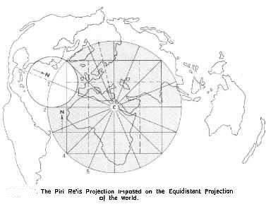
Knot work comes from Cording Lore which probably goes back to a time when people first had cording of some kind. Probably some bored soul on a rainy day with nothing better to do but make fancy patterns with his or her cording. Most of the patterns have names and meanings.  On the XPI page the cording is gold inside the big diamond, it’s the measuring cord or Whale’s Back which is the line all the Ogham symbols sit on.  He also has the measuring rod or surveying rod, the Hook which was a surveying or star watching device, a carpenter’s square, and the dividers which sit on the Druid’s nose and are made up by the beaks of the ibis.

When you turn the Druid upside down, the woven part of the beard now becomes a little man with big eyes, and he seems to have something long coming from the top of his head. Lugh- Cernunnos again. His head and arms rest on the curve. His ‘arms’ are actually two animal heads, one is a bird but I’m not sure of the other. Could be something doggie. Can’t see the detail well enough, but the whole thing does look like the Trilithon Horseshoe at Stonehenge.

I can’t see some of the smaller detail either, so he may have more messaging in that. However, I can see that some of the interlacing is made up of snakes, usually in pairs, and there are snails there also. Some are on the Druid’s face…….. think abstract. One of the more interesting snake configurations is at the bottom left hand corner. Two light coloured snakes and two red snakes both make a lozenge or diamond formation. Symbolic of the white and red serpent lines? If this is Jesus being born, then he would be of the red serpent line, or the Rose Line as it is sometimes referred to. Oddly enough, so were the Druids. The red dragon of Wales is still symbolic of the red serpent line.  The history of these two family lines comes from very ancient times and are connected to Ea/Enki and El/Enlil.

It is very interesting though that the monk shows both the ibis and the crane. Which makes me think there must be some connection there. It is very possible that their original knowledge came from Egypt. Thoth was the Ibis, and he certainly had all the attributes associated with Stonehenge. Astronomy, surveying, mathematics, writing, healing and equilibrium or balance. And a really interesting Wing String! (5)

Some of the elements of these manuscript pages, such as the humans, were considered rather childish, and everyone is still scratching their heads about the figure of St. John with hands for feet. (6) It takes a different way of seeing, and since most folk are so busy looking at the triskles, spirals and interlacing………..they don’t ‘see’. They can’t see the forest for the trees, and considering what is on this page, that’s incredibly funny. This is the most sophisticated use of Ogham that I have found so far, and likely there is more messaging in the smaller detail, it’s just too small for my eyes. A few days with the real page would likely clear that up, although it is not likely I’ll ever get to see it. I wish!

Most art lovers drool over this page, and most of them probably couldn’t put into words why they feel this way. Oh sure, we can all wax lyrical about the triskles, spirals and interlacing, but there is so much more there that we recognize somewhere deep inside us, subconsciously. Something our DNA recognizes, but out modern way of thinking has buried it for a long time.

It’s interesting to note that the knot work in the Druid’s beard makes the same formation as the Wessex lord’s ‘breast plate’ which has been dated c1900-1600 BCE. It was in a grave for at least two thousand years before this page was made. If you were to extend the net on the ‘breast plate’ it would give you the same formation in the Druid’s beard. The Wessex lord’s large gold lozenge may actually be a real Stonehenge artefact. The logo, if you like. And I think that originally came from the surveying for the Aubrey Holes. (7) I think that Julius Caesar may have had it correct, the Druids started in the UK and Ireland. When I started down the White Trail, I was not looking for Celts and their Druids, but ran into them just the same. The Wessex lord, from the Bush Barrow, with his interesting mace head was likely the Archdruid of his time, after all, his mace head is the original Druid’s Egg. Did he wear his gold lozenge on top of his turbaned head? A forerunner of the gold hats?

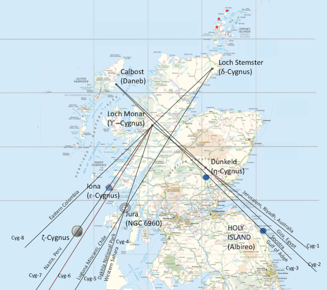
In my article Cygnus, Thoth, XPI and the Brodgar Complex, I showed how this page and the XPI page from Lindisfarne Gospels connected to the Orkneys with its ancient astronomers, surveyors and navigators.  Both Iona and Holy Island or Lindisfarne are sites belonging to the Cygnus that Derek Cunningham found on the landscape of Scotland. These two pages are a record of that ancient surveying, and tell us that it was the Orkneys which became the Mound of Creation. The place where astronomers, surveyors and navigators existed in ancient times.  Navigators because on the page from the Book of Kells, we find both Cygnus and the Southern Cross, both these constellations were used for navigation. What is really amazing is that all the ancient constructions on the Orkneys were created about three to four thousand years before these pages were made. If Derek Cunningham is correct with his dates for Cygnus being placed on the landscape of Scotland, then that was eight to ten thousand years before these pages were made. It’s obvious that there were still people connected to the early Church who knew about this history. And what about the Summer lord and Winter lord? which is what made me look at this page in the first place. They are there also. Lugh and Cernunnos.

References

The Book of Kells, described by Sir Edward Sullivan, however he writes nothing about what I have described

The Celtic Tree Oracle by Liz and Colin Murray

The Encyclopedia of Celtic Wisdom by Caitlin and John Matthews

(1) Cygnus, Thoth, XPI and the Brodgar Complex, by Joan Rankin

(2) The Bush Barrow Treasures, by Joan Rankin

(3) Maps of the Ancient Sea Kings, by Charles Hapgood

(4) Ancient-wisdom.co.uk

(5) Following the White Trail to Stonehenge Part IV by Joan Rankin

(6) The Amazing Book of Kells by Joan Rankin

(7) Following the White Trail to Stonehenge Part I by Joan Rankin

Pictures

XPI page from Wikipedia under The Book of Kells

Detail of the large diamond by Yetac

Forfeda by Joan Rankin

Mapping device from Ancient-wisdom.co.uk. This was originally in Charles Hapgood’s book Maps of the Ancient Sea Kings.
Back in the Present

Today I found myself firmly planted in the present as I was standing in my garden on a golden August afternoon, contemplating all the work which needs to be done.

I live in a small house, in a small grove, surrounded by woodland and nature in general. The wildlife includes black bears, moose, deer, foxes, bobcats, lynx, coyote, raccoons, beaver, otters, muskrats, and the ever present squirrels, chipmunks, mice, voles, frogs, toads, salamanders and snakes. The air is full of birds small and large, including bald eagles, osprey, hawks, ravens, crows, herons and the wee comedians, the hummingbirds.

The small grove is filled with shrubs, flower beds, vegetable plots, gravel paths and bits of lawn. Around the edges can be found patches of wild strawberries, raspberries and blackberries.

Although it was still a beautiful summer day, the quality of the light has changed. The sun no longer rides as high in the sky, and the shadows are lengthening. Soon it will be fall, and the maple tree behind the house will flood the back porch each morning with its lovely orangey red colour.

The countryside, with its valleys and hills, will look glorious then. The fields, like pieces of green velvet, will be surrounded with red, orange, gold and russet trees, shrubs, and bracken. But soon enough the rains and high winds will blow the leaves in great drifts in every nook and cranny of the garden. This is a very busy time for me. A time of gathering. A time to pick the vegetables and berries, and process them for winter, which generally means much blanching of vegetables, jam, jelly and pickle making. Apples will be picked and sliced, and stored in the freezer to make pies and apples sauce during the winter. The gardens must all be cleaned up before the snow comes, and there is still a pile of fire wood to be put under cover, so I won’t freeze during the cold months ahead.

Perhaps it seems odd to be thinking about winter at the end of August, but when it comes, it can come with a vengeance. Then I’ll be staying cozy and warm by the wood stove, reading books and using my computer. Then I’ll be sticking close to home and digging into ancient history once again, but for the moment I must attend to my chores for a while, so I hope that you will understand that I will not be posting anything new for a bit, because it will be work, work, work from morning till night. By the end of the day I’m usually just too tired to concentrate on ancient history, or anything else for that matter.

Correction to the Stonehenge Calendar

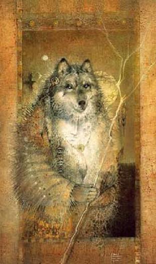
Grandfather Wolf has struck me in the head with his lightning stick today. Wake up old girl! You’ve made an error in the calendar at Stonehenge. I am posting it here so that anyone who has already seen it will know about this error and correction. I’ll also edit my original post, so that it will be corrected.

The whole problem stems from my thinking, Sumerian calendar, and that 11.25 minutes which add up to one day in 128 years. Oddly enough this 128 years is a coincidence, because it still belongs to the calendar at Stonehenge, just in a different way. I was reading Secrets of the Great Pyramid by Peter Tompkins, when I came across the following:

” The present calendar derives from the early Romans, who had a ten month year of 334 days, hence our September, October, November, December. In the 7th century B.C. Numa Pompillus is credited with adding January and February for a lunar year of 354 days. The shortage of 11 1/4 days caused the seasons and the calendar to diverge to the point where Julius Caesar was obliged to add 91 days to 46 B.C. and succumb to the suggestion of Cleopatra that he adopt the Egyptian civil calendar of 365.25 days. Even so, the difference between the civil calendar and the actual solar year of 365.2422 days added up to an extra day every 128 years, which obliged Pope Gregory XIII to drop 10 days from 1582.”

This means that at Stonehenge, leap year was missed every 128 years. Instead of adding two days, as I said in my original piece, you would add no days at all. So that cycle of 72 and 128 years still stands except for this one detail. It also means that the people at Stonehenge were keeping a more accurate calendar than either the Egyptians or the Sumerians in 3154 BCE. What makes me think this is correct, is the way the Aubrey hole circle is set up.

The red dots are the Station stones. They were not used to count with, only the Aubrey holes and the spaces in between. The days were counted counter clock wise on the spaces, the years counted clockwise on the Aubrey holes. The green dots are the 10, 9, 9 year counts connected to the eclipses. Counting from Aubrey hole 1, all the way around the circle and on to Aubrey hole 16, will give 72 years. If you count around the circle again and  back to 16, you have counted 128 years. 72 + 56 = 128 The second cycle of 72 and 128 years, starts at Aubrey hole 29 and ends at 44 for 72 years. Go around once more, and you have 128 years. Aubrey holes 16 and 44 are marked by the blue dots. This was the best way to keep track of these two cycles.  After the first 72 years, you would need to start a new 72 year cycle because the first counter would be busy continuing on until it reached 128 years.  The 72 year period had to do with Precession of the Equinoxes, and the 128 years with that missed leap year. 72 years also figured in the orbits of Venus and Jupiter as explained in the original piece.

The people who designed this were very efficient. Everything would have worked smooth as clockwork. These were all important cycles in their calendar. The mounds and ditches around the two Station stones were put there to help the counters know where they were in their count. The eclipse cycle count fell on the opposite side of the Station stones from the 72 and 128 year cycles.

I have also been reading The White Goddess by Robert Graves. He has many mistakes in that book and apparently admitted to making up the tree alphabet calendar. But one of the things he said may in fact be correct. He said that the ancient Celts had a calendar which had 13 periods of 28 days each, and that the year was 364 days plus 1 day. There are many stories which mention a year and a day, he thought this came from their calendar keeping. The year was 364 days, plus 1 day. When a year is counted on the Aubrey hole circle, you have to go around the circle six and a half times. This gives 364 days or 13 periods of 28 days each. One more day had to be waited for before the year was finished. The calendar at Stonehenge certainly connects to what he said, so I think that was correct. This is the original ancient Celtic calendar, likely home-grown, after all, they had some 4000 years to sort out the astronomy there. Those first posts on the Equinox line were put there 4000 years before the Aubrey hole circle was built. They had it all sorted out, by that time.

References

Secrets of the Great Pyramid by Peter Tompkins

The White Goddess by Robert Graves

Following the White Trail to Stonehenge Part II

Pictures

Grandfather Wolf and His Lightning Stick by Susan Seddon Boulet

Ground plan of Stonehenge, Ancient Monuments Branch, Ministry of Public Buildings and Works, England

The Amazing Book of Kells

The Book of Kells is considered the pinnacle of Insular illumination. Insular art, referring to the fact that the type of artwork found within the Book of Kells, the Lindisfarne Gospels, and other such manuscripts, was only found in the UK and Ireland. Perhaps it should be Insular Celtic art, that is at the root of the decorations. These include spirals, triskels, and the most complicated interlacing made up of vegetal, animal and human elements. The Book of Kells has the most ornate decoration which can be found in manuscripts dating c600-900 CE.  There is still a great deal of debate about its creators, and the place it was created at. It is called the Book of Kells because it resided at the Abbey of Kells in Ireland for many centuries. However, the tradition which names Iona as its place of origin may be correct, since the Chi Rho or XPI page does tie it to the one from Lindisfarne, and the Cygnus formation Derek Cunningham found on the landscape of Scotland. This star map includes Iona, Dunkeld and Holy Island, which is also known as Lindisfarne. St. Columba started his career at Kells, was sent to Iona to found a church there, and was also said to have built a church at Dunkeld. Iona was the mother house of Lindisfarne.

There are traditions which credit St. Columba with some of the artwork, but the experts think it dates c800 CE, later than St. Columba, who died in 597 CE. Their opinion is based on palaeographic and stylistic grounds. Since I’m not an expert, I won’t argue with that, but the Book of Kells includes much older, Celtic pagan symbolism, and at least one person creating the artwork understood Ogham.  I discovered the pagan symbolism after studying many examples of Celtic art, which very often include double heads. Sometimes it is presented as one head, but if you turn it upside down, it looks like a different head. Sometimes it is two heads or two men, symbolic of the Summer lord and the Winter lord.  There are also examples of a man’s head becoming a woman’s head when turned upside down. This is usually the goddess and her consort. I wondered if this had continued on in the monasteries, and found it did in the Book of Kells, at least on some pages.

Since I’ve only just written about the propheta head-gear, I thought I’d write about the portrait of St. John first. This page has always been a bit of a mystery, since St. John seems to have hands for feet. The monk did know how to draw feet, there’s a pair of them below the frame of the picture. Incredibly, some of the artwork in this book was considered rather childish at one time. I have not read any of the latest books devoted to the Book of Kells, so I don’t know if someone else may have recognized some of the things which I have found there. However, in “The Book of Kells”,  as described by Sir Edward Sullivan, which also includes a historical analysis of Celtic illuminated manuscripts by Johan Adolf Bruun, there is no mention of the things I have discovered. Only the obvious is mentioned, but the things I find just as obvious are not mentioned. Perhaps the critics of the early 1900s didn’t recognize the old Celtic pagan and astronomical messaging.

Once I had recognized the propheta head-gear, I realized that it is a person kneeling in front of St. John, that’s why he has his hands on the floor. St. John wrote Revelations and became a prophet by doing so.  The way it has been designed, makes it look as if it is part of St. John, but may hold more meaning. If this propheta head-gear was part of the druid tradition, then it is showing the old propheta kneeling and bowing his head to the younger one. Christianity taking over from the old ways. This monk created some of the most outstanding pages in the book, that I have seen. Even if it was c800 CE, this monk was still hanging on to the old ways, and like a true Celtic artist, he left messaging in his work. The sort of messaging which many people have totally missed, because much of the symbolism is very old. The Hittite hieroglyph for ‘propheta’ dates between at least 1700-1200 BCE. Even if it was 1200 BCE, it would still be a 2000 year old symbol this monk was using.

The clue to this page is on the book St. John is holding. There we have a lozenge or diamond divided in four. The lozenge or diamond, and the number four both symbolize the ‘hidden secret’. No lozenge or triangular shape in or on ancient artefacts in the UK and Ireland should be disregarded. They all belong to the knowledge of the astronomer, surveyor, navigators. It’s a signature they left behind. The first thing I noticed on this page was the haloed head, then the beard and down the arm, which is positioned in the wrong place. No doubt on purpose. This is the one holding the book, which told me there was a hidden secret on this page. The secret being the kneeling prophet.

I think two different people worked on this page. The original monk created the layout, the central figure, the four corner decorations, and the decorations around the frame.  He has the two faces on the outside of the four corners. These look more animal than human, but they are still the Summer lord and Winter lord. The four equal armed crosses and the rectangles on the border were filled in by someone else.  Someone not quite as talented as the original artist.

The corner detail is quite wonderful, its been bordered in yellow with a step formation suggestive of lightning. Inside of this is the Square of Enlightenment, the square with its corners turned to the cardinal points, which contains two white dogs entwined with eight horned serpents. Likely the dogs’ ears were red. Many Sun gods were accompanied by white hounds with red ears. The dogs in this picture are the two halves of the year. The eight serpents represent the eight divisions of the year. Their bodies form twelve triangles, the twelve months of the year.

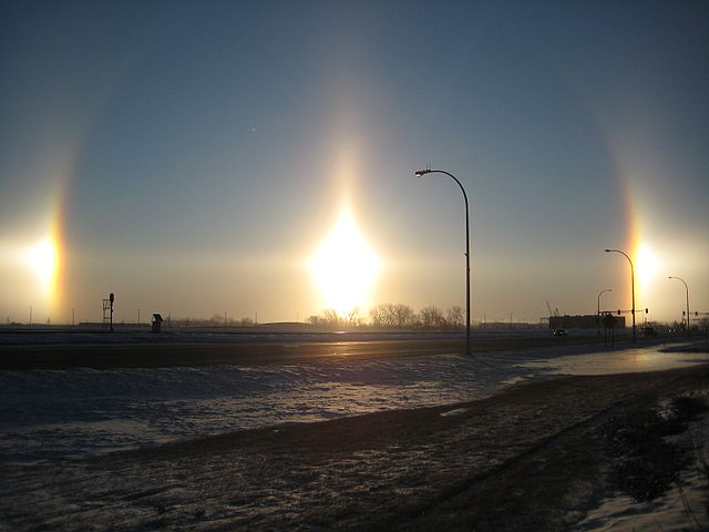
There are a great many stories about the white hounds with red ears, which made me wonder what that was all about. Looking at it astronomically, I discovered that these likely started out being Sundogs or parhelia. Parhelia comes from the Greek word, parelion, meaning ‘beside the Sun’. These are an atmospheric phenomenon that creates bright spots of light, often seen on a halo as shown below. They are often coloured, with red closest to the halo, and white and then blue further out. They appear to the left and right of the Sun, 22° distant and at the same level as the Sun.

Sundogs can appear anywhere on Earth at any time, but are best seen at dawn or Sun down, and since atmospheric ice crystals create this interesting effect, they are seen more often at cold times of the year. There are also Moon dogs which people seldom see, since it’s at night. Like eclipses, they were feared in ancient, and not so ancient times. They were generally viewed as bad omens. Hence the stories of Hell hounds, which were white with red ears. Since it appears like three Suns, I have to wonder if this is why Lugh/Lugus was sometimes shown with three faces or heads. The Sun in the centre is referred to as the ‘pillar’. Oddly enough it has a triangular head, similar to the Lugh’s head I hung at Stonehenge.

References

The Book of Kells, described by Sir Edward Sullivan, with commentary by Johan Adolf Bruun

The Book of Kells, Wikipedia

The Book of Kells, about.com, Medieval History

The Weather Doctor, Sundogs

Wikipedia, Sundog.

Picture of Sundogs at Fargo, North Dakota, taken on 18 February, 2009 by Gopherboy6956, found at Wikipedia.

Portrait of St. John from the Book of Kells found at about.com, Medieval History

Cygnus, Thoth, XPI, and the Brodgar Complex

The story about the two XPI pages from the Book of Kells and the Lindisfarne Gospels, has become somewhat more complicated, but much more enlightening, since it explains why these two pages used the same theme. At these two places. The Book of Kells was made on the Island of Iona, which is on the west side of northern Scotland. The Lindisfarne Gospels were made at Holy Island, off the north east coast of England. Iona was the mother house to Lindisfarne.

The big X on both pages, which is a bird, the Swan, is laying an egg with his wing tip upon something with the head of an Ibis. There’s the head of a man, who seems to be wearing some sort of turban. They both have the straight staff and the one with the curl in it, which are the bird’s legs. They both have many other things made up of triskels, which make up little pictures, and both have birds entwined. The Book of Kells also has serpents  and ‘beard pullers’ entwined. These two pages belong to the story, ” Thoth, as the Ibis, laid an egg on the Mound of Creation, which is Hathor as the Milky Way. From the egg, Ra, the Sun god was born”. Even though both these pages say XPI for Christos, which is the Greek version of the name. The early Christian manuscripts were written in Greek, Latin didn’t come to the UK and Ireland for a few centuries after Christianity arrived.  Both books do use Latin in the script, but in special cases, Greek still shows up, particularly in the Book of Kells. As in the word Christos, since the monk who created the page in the Book of Kells, actually spelled out the word on the page. He also used Ogham to give symbolic messaging, craftily hidden in plain sight. That is, if you can recognize it.

Triskels are basically shapes with three corners, which according to the experts represent the Trinity, but they came into existence long before Christianity, so a different sort of Trinity at one time. Past, Present and Future, the three Planes of Existence. The picture below  shows the sorts of shapes they could become, but the sky’s the limit when it comes to the different shapes, as long as they had three corners. Beard pullers are men with one lock of hair and their beards knotted up with each other or some other object.

Sometimes when I want to write about a topic, I seem to hold back. It’s not prevarication, rather it feels like waiting. Waiting for what? Waiting, because I feel that there is something missing about that particular topic. Something which will be important, something which might explain the subject. I take notice of this feeling, because I have found other things when this has happened before. I generally search the web for artefacts and articles, or I read some of my books, not really knowing what I’m looking for, but knowing I’ll find what ever it is I’m supposed to find. Quite often, the find is a coincidence, like someone posting an address on another blog, which just happens to give me one of my answers. This did in fact happen this time, but along with that, I also found something else. The two together are quite interesting.

The first thing I came across, were some papers written by Derek Cunningham, in which he theorizes that there was once a world map created, which was based on Cygnus. He actually started out trying to disprove the theories of Andrew Collins in the Cygnus Mystery. Andrew Collins and Rodney Hales showed how the layout for the Great pyramid and its companions match the formation of Cygnus better than Orion, which is logical, since Thoth was supposed to have been the architect of the Great pyramid. Thoth being Cygnus, usually shown as the Ibis. Instead, Derek Cunningham found that this theory is correct, and that it connects to a whole world map based on Cygnus, the Swan or Northern Cross, which seems to have been used by ancient mariners. Just can’t get away from those astronomer/navigators. His theories, maps, and pictures do suggest that he is correct about the world map.

His map of Cygnus on the landscape of Scotland was based on geoglyphs that he found. They include large Xs, parallel lines, a triangle with lines leading in all directions coming off it, and some strangely shaped lakes. He also took into account the ancient Christian places of Iona, Dunkeld and Holy Island because they were supposed to have been built on land which was sacred long before Christianity came along.  Close to Dunkeld there is a nest of lines, parallel, triangular, etc. The map below is part of the result. This is a mirror image of what appeared in the sky when  this mapping system began, which Derek Cunningham dates to between 10,000-12,000 BCE. So right after the Big Ice had mostly melted away. As can be seen, these lines run to other important places in the world, and one from Calbost runs all the way to Giza in Egypt and beyond. It could take you to Australia, particularly if there was a canal in ancient times where the Suez canal is now. I have read about such a canal more than once in my lifetime. The line running to Jerusalem is likely Mount Carmel which figures in the St. Michael-Apollo Line.

However, Scotland didn’t look quite like this at the time, since this is before the Storrega Slide, and the incredibly bad tsunami it created, wiping out a great deal of Doggerland, and parts of Scotland. The Hebrides and the Orkneys were then part of a solid piece of land as shown below. These Islands must have been high points of land for them to have survived the flooding.  This is likely why so many islands, all the way back to Cyprus, were considered holy islands. They survived all the flooding which took place after the Ice Age ended. This is probably why so many ancient constructions were placed on high ground, they might survive if there was ever anymore flooding. This likely accounts for megalithic building, even though most of it happened much later.

The three red dots on Derek’s map, are ones I added. These are three wing stars which are part of Cygnus, which he didn’t take into account, but I did, knowing what is up there. Many Christian, Roman and Norman sites were built over much older sites, which were part of the original geodesy. It is possible that the very early Church had people who still understood this. At least it would seem so with the two XPI pages.

These three dots are very important to this story. I first put in the dots, and then went to look at a close up map of the locations. One is on Mainland Orkney, where there are two major roads which cross in a  big X formation. One dot falls on water, possibly land when this was created. The third dot is on Papa Westray, where an ancient tomb named the Holm of Papa Westray, and the Knap of Howar can be found. Up until a few years ago, the Knap of Howar was the oldest farm in Europe, it dates c3700 BCE. Since then, another farm has been discovered on the east side of Scotland, which has been dated c4000 BCE. The people there kept cattle, sheep and pigs, and grew several types of grain crops. The island of Wyre has also produced a settlement which so far dates c3300 BCE. Jura had people settled there in the Mesolithic. Scotland is becoming a regular hotbed of ancient constructions, and archaeologists are now realizing that the Orkneys do seem to have been the centre of some very important goings on. There’s the Barnhouse settlement close to the Stones of Stennes, and possibly two close to the Ring of Brodgar. One settlement has been found north of Brodgar by magnetometry scans, a whole new settlement which was unknown up until now.

It is the view of the archaeologists that the whole peninsula of Brodgar could well hold a great deal more. A circular enclosure has been spotted from the air close to Maeshowe, although it isn’t known at present what this might be. What has been uncovered so far at Brodgar, suggests that there were alignments to the Equinoxes and the Solstices, so all Solar.

These buildings at Ness Brodgar are quite substantial, particularly Structure Ten. It measures 25 metres (82 feet) long and 20 metres (65 feet) wide in outside dimensions. The walls are five metres thick. It has a paved walkway all around, which may also have been covered by the roof.  Inside have been found a central hearth and four ‘dressers’, although these are now being viewed as ‘altars’. These were free-standing rather than placed against the wall as at Skara Brae. Far enough away from the wall so that you could walk around it.  They were made of yellow and red sandstone, their origin is not known at the moment, but this sandstone was brought from elsewhere.

                                                                            A  typical ‘dresser’ at Skara Brae

Structure Ten at Brodgar has now been jokingly called the ‘Cathedral’. Structure Eight at the Barnhouse settlement, close to the Stones of Stennes, shows evidence of having had a slate roof, many slates were found inside, all nicely even in thickness and cut squarely. Some have also been found in structure Ten. Neither hearth in Ten or Eight seems to have been used for cooking, all cooking at Eight seems to have taken place in an adjacent paved area outside. At Skara Brae, all the cooking seems to have been done in a building separate from the rest. Very monastic-like.

The outside stonework of Structure Ten was very well made and quite beautiful, but the inside stonework was rather “scrappy”, says Nick Card, archaeologist at the site, as if the building was meant to impress from the outside, but few people may have actually used the inside. The building is aligned east/west, with an entrance in the east, an Equinox alignment. Near the altar/dresser, which faces the east entrance, was found a stone now known as the Brodgar Eye. It is thought to have been part of this altar/dresser, and that the Equinox Sunrise would have shone right on it. Nick Card wondered if this was a Sun symbol. Yes indeed, it is a very ancient Sun symbol, and in Egypt it was a symbol for light. The monk who created the XPI page from Lindisfarne, used it on that page. The Druid’s beard is flowing toward it.

My own thought about this building, is that this was the headquarters and workplace of the astronomer/navigators. The altar/dressers were desks, a work surface to create maps on, likely made on hides. The tops themselves may have star maps on them, since they have pecking and cup marks and ‘decoration’ on them. The shelves below were for these rolled up hide maps, their ink cakes and pens made of reeds or quills. Swan’s quills? The Equinox Sunrise alignment makes perfect sense, the best long distance sailing time occurs between the Spring and Fall Equinox, particularly in a time with no motors, radio, radar, GPS, and all the other modern gear we have today. Even with all that, the Atlantic is no picnic in December.

It is starting to look as if all the Orkney Islands were inhabited in the Neolithic and Bronze Age, and that they were inhabited for at least a thousand years.  But the excavations are nowhere near finished, and the archaeologists think that there could still be whole layers of other constructions further down at Brodgar, which could show that it was inhabited for a much longer time. At the Links of Notland, on Westray, another settlement is being excavated. This is where the Orkney Venus was found. It has the same eyebrow/eye motif which was found at the Holm of Papa Westray, a chambered cairn.

These carvings are reminiscent of the Folkton Drums which also have the eyebrow/eye motif on them.  The motif on the Folkton Drums is part of the Akhet, the Sun between two mountains. The Winter Solstice Sunset, as seen from Maeshowe and other places belonging to the Brodgar Complex, happens between two mountains, where it sets into the Island of Hoy. There are special sightings of Venus about those same mountains. The eyebrows on the Folkton Drums is a large winged bird, Cygnus. Another carving has been found on Westray, part of the wall of what is considered an important building, also with fine stonework and larger than the rest so far excavated. Here we have the Akhet again, and that story, “Thoth, as the Ibis, laid an egg on the Mound of Creation, which was Hathor as the Milky Way. From the egg, Ra, the Sun god was born”.

That big winged bird was of prime importance to the world map, which Derek Cunningham discovered. He drew lines running from the various sites in Scotland on a world map in the following picture. Notice how there are three lines running from Scotland through the area of the Suez Canal? They could take you right to Australia, if there had been a canal there in ancient times.

Certainly looks as if Scotland was the place for ancient astronomer/navigators. And what do the two XPI pages have to do with this? Turn the pages upside down, and now consider the Cygnus over Scotland map, and the Mound of Creation with its Ibis head, now becomes the Orkney Islands. Holy Island is Albireo, the head of the Cygnus Constellation. The Druid’s head on the Lindisfarne page has his beard flowing toward the south west, the direction of Sunset of the Winter Solstice. The head on the Kells page is facing west, the direction of Sunset on the Equinoxes. Seems those monks who made these pages, must have been aware of this lovely piece of geodesy, and they left us a record of those times, which occurred thousands of years before they were born. St. Columba, of Druid heritage, was at Iona, and seems to have built a very early church at Dunkeld. The later medieval Cathedral there was dedicated to St. Columba. With his background, he may have known about this geodesy. Iona was a Druid mystics’ retreat long before Christianity.

Were the people at Brodgar Druids? At the moment it isn’t known, but it is believed that there was an elite priesthood there. One which was certainly concerned with astronomy. Much artwork has been found there, although I have only seen the Brodgar Eye. One building had a stone with eight rows of lozenges, another had a cist in the floor covered by a triangular stone. It was situated in such a way, that you would have to walk over it. There are also other markings there, which by the description could be Ogham. Perhaps I can get some pictures, that is if I can get any answers from the archaeologists. One can only hope at the moment, but the Brodgar Eye and the Akhet, do point to Egyptian connections, even the monks made the head of the Mound of Creation, the head of an Ibis. As far as I know, there is only one connection to an Ibis, and that’s Thoth in Egypt.

Derek Cunningham made many interesting discoveries, but one in particular caught my eye. A spiral hill on Iona, I outlined what I could see there. Hmmm………The Horned Man? Or does this actually mean something else?

Among the contents of a Hittite sign list, I found a symbol for, propheta. This word is in Luwian, a language connected to Wilusa, which is where the city of Troy was. Propheta is self-explanatory, prophet, in other words. But a prophet in ancient times, probably started out as an astronomer/astrologer. They made prophesies using the Sun, Moon, planets, constellations and other stars. What he has on his head is a sort of turban with long tails, which explains the head-gear being worn by the men on the two XPI pages, and likely this head on the landscape of Iona. As I said, Iona was a Druid mystics’ retreat long ago. Mystics are often prophets. If this head is as old as many of the other geoglyphs, then the people at Brodgar likely were Druids. They were at Silbury Hill c2500 BCE.

References

Midnight Science Journal, papers by Derek Cunningham

Orkneyjar, postings by Sigurd Towrie

Dunkeld, Wikipedia

Pictures

XPI pages from the Book of Kells, the Lindisfarne Gospels and the Doggerland map, Wikipedia.

Map of Cygnus over Scotland, World line map, and the spiral hill on Iona, Midnight Science Journal, papers by Derek Cunningham. Cygnus over Scotland on an Ordinance survey map. World map from Mapquest. Iona spiral hill from Google-Imagery

Propheta from Hittite Sign List pdf. author Gunter Anders

Cygnus map, starrynighteducation.com, Oaklands Astronomy Club

Orkney Venus, carvings at Holm of Papa Westray, the Brodgar Eye, picture of excavation at Brodgar, picture of the Akhet stone, the stone dresser at Skara Brae, and the magnetometry scan from Orkneyjar, posted by Sigurd Towrie

Folkton Drums, Ancient Celtic New Zealand.

Contemplating the Ancient Mind


There is a great deal written about what ancient people thought about life, death, religion, and how they viewed the world around them.  These are all personal views, which quite often have little basis in fact. One archaeologist thinks that Stonehenge was a Temple of Death, while another thinks it was a Neolithic Lourdes. One basis his belief on the fact that there are many people buried within and around Stonehenge, but then again, his specialty is in ancient death practices. The other, basis his belief on the fact that many people seem to have died of some trauma. Many head wounds were found, and such people as the Amesbury Archer with his missing knee cap and his abscessed jaw. He believes that people were brought there to be healed. He may not be far off. The 19 Bluestones in the Horseshoe gave Eadha or White Poplar in the Ogham tract. It is connected to healing and rebirth, and when the wind blows, the leaves rustle, giving that small still voice of God. Important medicines were made from it.

They may both be right, or not. There are hundreds of theories about Stonehenge, ranging from, it was an alien’s landing pad, to, it was a place for human sacrifice. The truth is, no one really knows what it was for, although the people there do seem to have taken an uncommon amount of notice of the objects in the sky, and the calendar. Obviously this was very important to them, and they left their monuments, stone markers, tumuli, tumps, mounds, long barrows, and other such constructions all over the landscape in the UK and Ireland. Each one of these things seems to have been placed at that very spot on purpose, creating interesting geodesy. As an example, Callanish is 5° north and 5° west of Arbor Low, which is  2° north of Stonehenge. The Callanish stone circle and its outliers look like a big winged, long legged bird. Arbor Low’s recumbent stone ‘circle’ is white quartz and egg shaped. Stonehenge is 1° east of Glastonbury Tor. Creswell Crags, and its interesting bird carvings, is 9° west of Heligoland. These are only a very tiny bit of what exists on the landscape, there are hundreds of other examples. Sure looks as if someone was mapping the place methodically.

In later times, many of these sites were built over with churches, chapels, shrines, castles, and Templar buildings. They erased, or tried to erase, the ancient constructions, but kept the geodesy alive, and the Knights Templar were likely the only ones who knew and understood the geodesy. This didn’t just happen in the UK and Ireland, it was also created all over Europe, and all the way back to the Middle East. Actually, this can be found all over the world, and all these places appear to connect together, belonging to one world mapping system. There was a group of people who wanted a world map. The only people I can think of, who would need such a thing are, navigators, traders, merchants, and explorers, looking for minerals and anything else of worth. No doubt sent out by rulers of established societies. It has often been said that farmers did not need a calendar to plant or harvest by, which is quite true, the weather conditions and the ripeness of the crop tells me that. But if you were a navigator in ancient times, it would be very important to know which month it was. Just because it may be sunny and warm on land in March, the oceans are not that accommodating in March.

However, I thought I would have a look at some things which appeared somewhat simpler, to see could I catch a glimpse of that ancient mind. The first is a necklace from the West Kennet Long Barrow, possibly 2500 BCE, and the other is the original core or mound of Silbury Hill.

This necklace is incredibly primitive looking, what with the stones and the bone. The objects are: a piece of bone, a tooth, a piece of tusk, a shell, and three pieces of shale. One piece of shale is very dark, and looks as if it has been polished. The shale wheel, at the front, has been made so that the line between two layers of shale falls in the centre of the wheel. It may also have some decoration on the side. It can be seen that the craftsperson put a lot of work into making nice round shapes. I couldn’t imagine why someone would put such a thing together, and yet it must have had an important meaning, since it was buried with someone in the West Kennet Long Barrow. The piece of bone kept tugging at my brain, until I realized that all these things have the same function. Stone is the bones of the Earth, creating its contours. All animals have bones which gives them their structure and shape. Snails have no internal skeleton, their shell is their exterior one. A tooth and a tusk are extensions of bone. Even after everything else has decayed, the skeleton with its teeth and tusks remain, and would have been seen as belonging with all these ‘bones’. All bones of different varieties.

So, primitive looking, but well thought out, and many hours spent creating the different pieces. The four light pieces may have represented the four Albans, which are the two Solstices and the two Equinoxes. The dark pieces, plus the person wearing it, would then represent the four Fire Festivals, February 2, May 1, August 1, and October 31. The deceased would then represent that dead period between October 31 and December 21. October 31  was the time of the year when the veil between this world and the Otherworld was believed to be the thinnest, and that one could communicate with one’s dead ancestors at that time. The tooth is December 21, the Coming of the Light, and Cernunnos, when much pork seems to have been consumed at Durrington Walls. The polished shale is February 2, the Feast of Brigid, the bone is the Spring Equinox, the central wheel is May 1, which festival was celebrated by bonding of male and female. The tusk is June 21, the shale wheel, August 1, and the shell is the Fall Equinox, and so back to October 31. A fitting necklace for someone going to their grave. Quite possibly made just for this purpose, not something worn in life, only in death.

Silbury Hill also has such a puzzle at its original core, which was a simple mound. One statement I read said that nothing of significance was ever found at the core of Silbury Hill, only sarsen, flint, clay, topsoil, moss, turf, fresh water shells, ox bones, antler tines, Oak, Hazel and Mistletoe. Those last three made me perk up, seems there may have been something very significant there. These various items can be put into groups. Sarsen and flint, clay and topsoil, gravel and shells, moss and turf, ox bones and antler tines, Oak, Hazel and Mistletoe. Since Mistletoe is a parasite which lives on other trees, this can be seen as six groups of two, even though there are thirteen separate types of objects. They represent 12 Solar months and 13 Lunar months, which take almost the same length of time. Mistletoe was gathered with golden sickles at the full Moon closest to the Winter Solstice.

Stone is the bones of the Earth, covered by clay and topsoil, which is covered by moss and turf. Oak and Hazel grow above the moss and turf. Mistletoe grows on Oak. Gravel belongs with water. Wherever you find gravel, water once flowed there. The shells also belonged to the water element. The two land animals, cattle and deer, represented the Summer Lord and Winter Lord, but also two prime sources of meat, hides and all the other parts which were used for various things. The stones found were sarsen and flint. Sarsen was used to build all the megalithic constructions in the area. Flint was used to make all common tools which were essential for day-to-day living. Clay was used to make pottery, and food such as a bird or fish were often wrapped in plantain or some other leaves, and then covered in clay. It could be placed close to the fire or in a ground pit for slow cooking. A slab of clay was placed in boats, and used as a hearth for cooking on. It was also used to make clay tablets to write on. Topsoil is what you grow your crops in. Moss had many uses for personal hygiene, for insulation in shoes and boots, caulking in houses and boats, and had medicinal uses. Turf is where you find edible plants, roots, herbs, mushrooms, berries, medicinal plants, items to create dye, and grasses to weave into mats, bags and other containers. Turf was used to roof some buildings, even turf huts were created. Cattle and deer, live on the turf, not only to wander around on and sleep on, but to eat also.
The Oak, Hazel and Mistletoe are a dead give away as far as Druids are concerned. These three are among the most sacred in the Ogham tract, where each is given a chieftain designation. Oak represents solid foundation, solid protection, the Doorway to Enlightenment/the Mysteries. It represents the Druids themselves, they were the Doorway to Enlightenment/ the Mysteries, they were the teachers. The Hazel brings to mind the Hazels of Wisdom, which is just shorthand for all the knowledge the Druids had. Mistletoe was called All Heal and is used in cancer drugs today. At that time it was considered a fertility symbol, and was seen as a spiritual connection to the land. On the bottom of a Mistletoe berry, can be found four semicircles around a central dot. These represent the four cities of the gods, Filias, Finias, Gorias, and Murias. These represent the four cardinal directions, and the four ancient elements. Earth in the North, Air in the East, Water in the West, and Fire in the South. The central dot is the etheric centre which joins together the three planes of existence, past, present and future. This is the basic symbol for the Celtic equal armed cross, which can also be shown as the upright pentagram. The point at the top symbolizes the supremacy of the spiritual and divine over the world of matter, shown by the other four points. The most sacred Mistletoe grows on Oak, which doesn’t happen very often. Because Oak is so long lived, it is a powerful fertility symbol. Mistletoe on Oak would have been considered the most potent.

So what was Silbury Hill? No burials or treasure have been found to date. It started out as a tump, which looks much like a round barrow, although they can vary in size. Most tumps were way markers, and Silbury Hill is on the St. Michael’s Ley. There seems to have been some time between the building of this mound, and it being enlarged to become the great hill that it is today. It started out as a sacred connection to the land, sacred not only because of its contents, but also because it belonged to the geodesic system which existed there. After it had been greatly enlarged, it was probably a beacon hill. Even during the day it was glaring white, at night there would have been a fire there, and it still would have shone by the light of the Moon and stars.  Ancient-wisdom has the following to say:

“Silbury Hill is just one in a line of natural and artificial mounds along the St. Michael’s ley, which itself has a strong association with astronomy. Perhaps it is a coincidence then that Silbury Hill and Stonehenge combine with Glastonbury, the ‘Sacred Heart of England’, to form a vast right-angled triangle across the landscape. At the same time as the hypotenuse of this triangle reaches from Avebury/Silbury to Glastonbury, the opposite side is also part of a large geometric alignment, being one of the edges of the great Decagon first observed by J. Michell, while the adjacent side continues north to Arbor Low, and south to Mont St. Michel in France.

The line of the Sun would be Sunrise around May 8th, the Feast of St. Michael.

The map below shows what would happen if the water in the Kennet River was five metres higher, which it may have been at the time. Even Glastonbury Tor was surrounded by marsh and water in ancient times.

Silbury Hill now makes perfect sense. If you were sailing up the river, you wouldn’t be able to see Avebury because Overton Hill and Woden Hill would obstruct your view. Silbury Hill shows you the correct channel to sail up to Avebury Ring, which may have had a canal around it. The ditch there would certainly be wide enough and deep enough to accommodate small and medium sized boats. So, Silbury Hill became a large beacon hill on the old road systems, whether you were traveling by land or by water. Considering how many things it is connected to, it would certainly have been a sacred connection to the land. A major geodesic marker. Going NE on the St. Michael’s ley would eventually take you to Yarmouth, Heligoland and other places in Scandinavia. Going SW on the St. Michael’s ley, it connected to the St. Michael-Apollo line at St. Michael’s Mount, which could take you NW to Skellig Michael in Ireland, or SE to Mont St. Michel in France, and all the way to Mount Carmel in the Holy Land. Quite a network. Strange that we still refer to such a thing as a ‘network’. That’s exactly what those ancient astronomer, surveyor, navigators created, a network, marked by mounds, standing stones, circles, long and round barrows, ponds, springs, and sometimes trees as guide posts.

There are interesting things which happen at Silbury Hill. I watched a video online which showed Sunrise on the Fall Equinox at Silbury Hill. The Sun looked as if it were rolling up the hillside, and when it reached the top, it went sailing off into the sky. Someone knew the angle of this Sunrise and built the hill to match. Around May day, if you stand on Woden Hill, looking right at the top of Silbury Hill, you will see the Sun set right into the horizon and Silbury Hill at the same time.  Someone knew how high to make the hill to obtain this effect. So…….what is up on Woden Hill?  I’ve never heard of any archaeological investigating going on there, but Woden Hill is the best command post in the area. From there, you could see Windmill Hill, Avebury Ring, the Sanctuary, Silbury Hill, the West Kennet long Barrow, and all the way to Stonehenge, as well as the river system. Some theories have it, that Silbury Hill had a spiral path going around it from top to bottom. This would make it look like a snail from the air. Snail in Welsh is, malwoden, which could mean Woden’s Mill, and like a snail it is hugging the river bank on the map.  How ironic that it should be so close to Woden Hill, or is it? Or is this just another example of those ancient surveyors and their sense of humour?

Hmmm………….seems those two things weren’t that simple after all, and Silbury Hill led me right back to those ancient map makers.

References

Ancient-wisdom.co.uk

The Celtic Tree Oracle by Liz and Colin Murray

Pictures

Visioning by Susan Seddon Boulet

Necklace from the Wiltshire Heritage Museum

Silbury Hill, right-angled triangle and map from Ancient-wisdom.co.uk